MONOGRAFIA DE MARCOS - geofiles.caxias.rs.gov.br · Prefeitura Municipal de Caxias do Sul ... Lei...
1
Prefeitura Municipal de Caxias do Sul RCMGeo – Rede Caxiense de Marcos Georreferenciados Cfe. Lei nº 7.229, de 9/12/2010 e Dec. 15.232 de 15/04/2011. MONOGRAFIA DE MARCOS N° do marco: 216 Obra/Ano: Implantação/2010 DADOS GERAIS COORDENADAS SIRGAS 2000 Município: Caxias do Sul Estado: RS Localização: Marco no canteiro da Praça Duque de Caxias em Galópolis. Latitude: 29º13’49,15492” S Longitude: 51º09’29,11203” W UTM (N): 6.766.486,024 UTM (E): 484.636,616 Altitude ortométrica (m): 463,256 *Origem da altimetria: RN IBGE estação 1774V: 464,989 CROQUIS COORDENADAS PLANO TOPOGRÁFICO LOCAL/SIRGAS 2000 X: 150.000,000 Y: 250.000,000 Altitude ortométrica (m): 463,256 PONTO ORIGEM PLANO TOPOGRÁFICO LOCAL/SIRGAS 2000 Marco 216 – MARCO DE ORIGEM X: 150.000,00 Y: 250.000,00 Altitude ortimétrica (m): 463,256 Latitude: 29º13’49,15492” S Longitude: 51º09’29,11203” W UTM(N): 6.766.486,024 UTM(E): 484.636,616 FOTO MARCOS INTERVISÍVEIS RESPONSABILIDADE TÉCNICA RESPONSABILIDADE TÉCNICA: Mast Engenharia e Topografia Ltda. CREA/RS 051517
-
Upload
hoangkhuong -
Category
Documents
-
view
214 -
download
0
Transcript of MONOGRAFIA DE MARCOS - geofiles.caxias.rs.gov.br · Prefeitura Municipal de Caxias do Sul ... Lei...
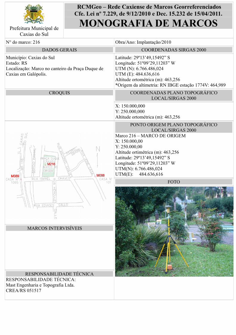
Prefeitura Municipal deCaxias do Sul
RCMGeo – Rede Caxiense de Marcos GeorreferenciadosCfe. Lei nº 7.229, de 9/12/2010 e Dec. 15.232 de 15/04/2011.
MONOGRAFIA DE MARCOS
N° do marco: 216 Obra/Ano: Implantação/2010
DADOS GERAIS COORDENADAS SIRGAS 2000
Município: Caxias do Sul Estado: RSLocalização: Marco no canteiro da Praça Duque de Caxias em Galópolis.
Latitude: 29º13’49,15492” SLongitude: 51º09’29,11203” WUTM (N): 6.766.486,024UTM (E): 484.636,616Altitude ortométrica (m): 463,256*Origem da altimetria: RN IBGE estação 1774V: 464,989
CROQUIS COORDENADAS PLANO TOPOGRÁFICOLOCAL/SIRGAS 2000
X: 150.000,000Y: 250.000,000Altitude ortométrica (m): 463,256
PONTO ORIGEM PLANO TOPOGRÁFICOLOCAL/SIRGAS 2000
Marco 216 – MARCO DE ORIGEM X: 150.000,00Y: 250.000,00Altitude ortimétrica (m): 463,256Latitude: 29º13’49,15492” SLongitude: 51º09’29,11203” WUTM(N): 6.766.486,024UTM(E): 484.636,616
FOTO
MARCOS INTERVISÍVEIS
RESPONSABILIDADE TÉCNICARESPONSABILIDADE TÉCNICA:Mast Engenharia e Topografia Ltda.CREA/RS 051517