CAPÍTULO 2 | CHAPTER 2 A VALIDAÇÃO DA DISTRIBUIÇÃO DE ...
30
27 Resumo 1. Os modelos preditivos de distribuição de espécies são uma importante ferramenta para lidar com a falta de in- formação biogeográfica existente para a maior parte dos taxa. Com esta técnica, estabelece-se uma relação entre a variável dependente (presença/ausência de uma espé- cie) e um conjunto de variáveis potencialmente predito- ras, e é criado um mapa com a probabilidade de presen- ça da espécie para uma determinada área de interesse. 2. Neste capítulo, é usado o programa Maxent para criar modelos de distribuição potencial de um conjunto se- leccionado de espécies, e os resultados obtidos são discutidos com base no conhecimento de especialistas nessas espécies. Abstract 1. Predictive models of species distribution emerge as a valuable tool for tackling the lack of distributional infor- mation on most taxa. A function between the dependent variable (presence/absence of the species) and a set of potential predictors is established, and a map is genera- ted for the focus area, indicating the probability of pre- sence of the species. 2. In this chapter, we use Maxent to develop potential distri- bution models for a number of selected species and we discuss the results on the basis of expert knowledge. 3. Some sources of uncertainty are mentioned, and the impossibilities of accounting for historical processes or variables acting at a very local scale are highlighted. CAPÍTULO 2 | CHAPTER 2 A VALIDAÇÃO DA DISTRIBUIÇÃO DE ESPÉCIES ATRAVÉS DE MODELOS PREDITIVOS: CASOS DE ESTUDO PARA A ILHA DA MADEIRA USING PREDICTIVE MODELS OF SPECIES DISTRIBUTION TO VALIDATE BIODIVERSITY DATA: CASE STUDIES FOR MADEIRA ISLAND Alberto Jiménez-Valverde 1,2* , Joaquín Hortal 3 , Jorge M. Lobo 2 , Paulo A. V. Borges 1 , Cristina Abreu 4 , António Franquinho Aguiar 5 , Eduardo Brito de Azevedo 6 , Mário Boieiro 7 , Susana Fontinha 8 , Roberto Jardim 9 , Paulo Oliveira 8 , Cecília Sérgio 10 , Artur R. M. Serrano 7 , Manuela Sim-Sim 11 & Duarte Nunes 12 1 Universidade dos Açores, Dep. de Ciências Agrárias – CITA-A (Grupo de Biodiversidade dos Açores), Terra-Chã, 9700-851 Angra do Hero- ísmo, Terceira, Açores, Portugal; *e-mail: [email protected]. 2 Departamento de Biodiversidad y Biología Evolutiva, Museo Nacional de Ciencias Naturales, C/ José Gutiérrez Abascal, 2, 28006 Madrid, Spain. 3 NERC Centre for Population Biology, Division of Biology, Imperial College London, Silwood Park Campus, Ascot, Berkshire SL5 7PY, UK. 4 Universidade da Madeira, Dep. Biologia/CEM, Edifício da Penteada, 9000-399 Funchal, Portugal. 5 Núcleo de Entomologia, Laboratório Agrícola da Madeira, Caminho dos Caboucos 61, 9135-372 Camacha, Madeira, Portugal. 6 Universidade dos Açores, Dep. de Ciências Agrárias – CMMG (Centro de Estudos do Clima, Meteorologia e Mudanças Globais), Terra-Chã, 9700-851 Angra do Heroísmo, Terceira, Açores, Portugal. 7 Faculdade de Ciências da Universidade de Lisboa, Centro de Biologia Ambiental, Departamento de Biologia Animal, R. Ernesto de Vascon- celos, Ed. C2, 2º Piso, Campo Grande, 1749-016 Lisboa, Portugal. 8 Parque Natural da Madeira/CEM, Quinta do Bom Sucesso, Caminho do Meio, 9050–251 Funchal, Madeira, Portugal. 9 Jardim Botânico da Madeira, Caminho do Meio, 9064-512 Funchal, Portugal. 10 Jardim Botânico, Museu Nacional de História Natural, Universidade de Lisboa, Centro de Biologia Ambiental, R. da Escola Politécnica, 58, 1250-102 Lisboa, Portugal. 11 Universidade de Lisboa, Faculdade de Ciências (DBV – Dep. de Biologia Vegetal), CBA – Centro de Biologia Ambiental, R. Ernesto de Vasconcelos, Ed. C2, Campo Grande, 1749-016 Lisboa, Portugal. 12 Direcção Regional do Ambiente, Rua Dr. Pestana Júnior, nº 6 – 3º Direito, 9064-506 Funchal, Madeira, Portugal.
Transcript of CAPÍTULO 2 | CHAPTER 2 A VALIDAÇÃO DA DISTRIBUIÇÃO DE ...

27
Resumo1. Os modelos preditivos de distribuição de espécies são
uma importante ferramenta para lidar com a falta de in-
formação biogeográfica existente para a maior parte dos
taxa. Com esta técnica, estabelece -se uma relação entre
a variável dependente (presença/ausência de uma espé-
cie) e um conjunto de variáveis potencialmente predito-
ras, e é criado um mapa com a probabilidade de presen-
ça da espécie para uma determinada área de interesse.
2. Neste capítulo, é usado o programa Maxent para criar
modelos de distribuição potencial de um conjunto se-
leccionado de espécies, e os resultados obtidos são
discutidos com base no conhecimento de especialistas
nessas espécies.
Abstract1. Predictive models of species distribution emerge as a
valuable tool for tackling the lack of distributional infor-
mation on most taxa. A function between the dependent
variable (presence/absence of the species) and a set of
potential predictors is established, and a map is genera-
ted for the focus area, indicating the probability of pre-
sence of the species.
2. In this chapter, we use Maxent to develop potential distri-
bution models for a number of selected species and we
discuss the results on the basis of expert knowledge.
3. Some sources of uncertainty are mentioned, and the
impossibilities of accounting for historical processes or
variables acting at a very local scale are highlighted.
CAPÍTULO 2 | CHAPTER 2
A VALIDAÇÃO DA DISTRIBUIÇÃO DE ESPÉCIES ATRAVÉS DE MODELOS PREDITIVOS:
CASOS DE ESTUDO PARA A ILHA DA MADEIRA
USING PREDICTIVE MODELS OF SPECIES DISTRIBUTION TO VALIDATE BIODIVERSITY DATA:
CASE STUDIES FOR MADEIRA ISLAND
Alberto Jiménez -Valverde1,2*, Joaquín Hortal3, Jorge M. Lobo2, Paulo A. V. Borges1,
Cristina Abreu4, António Franquinho Aguiar5, Eduardo Brito de Azevedo6,
Mário Boieiro7, Susana Fontinha8, Roberto Jardim9, Paulo Oliveira8, Cecília Sérgio10,
Artur R. M. Serrano7, Manuela Sim -Sim11 & Duarte Nunes12
1 Universidade dos Açores, Dep. de Ciências Agrárias – CITA -A (Grupo de Biodiversidade dos Açores), Terra -Chã, 9700 -851 Angra do Hero-
ísmo, Terceira, Açores, Portugal; *e -mail: [email protected] Departamento de Biodiversidad y Biología Evolutiva, Museo Nacional de Ciencias Naturales, C/ José Gutiérrez Abascal, 2, 28006 Madrid,
Spain.3 NERC Centre for Population Biology, Division of Biology, Imperial College London, Silwood Park Campus, Ascot, Berkshire SL5 7PY, UK.4 Universidade da Madeira, Dep. Biologia/CEM, Edifício da Penteada, 9000 -399 Funchal, Portugal.5 Núcleo de Entomologia, Laboratório Agrícola da Madeira, Caminho dos Caboucos 61, 9135 -372 Camacha, Madeira, Portugal.6 Universidade dos Açores, Dep. de Ciências Agrárias – CMMG (Centro de Estudos do Clima, Meteorologia e Mudanças Globais), Terra -Chã,
9700 -851 Angra do Heroísmo, Terceira, Açores, Portugal.7 Faculdade de Ciências da Universidade de Lisboa, Centro de Biologia Ambiental, Departamento de Biologia Animal, R. Ernesto de Vascon-
celos, Ed. C2, 2º Piso, Campo Grande, 1749 -016 Lisboa, Portugal.8 Parque Natural da Madeira/CEM, Quinta do Bom Sucesso, Caminho do Meio, 9050–251 Funchal, Madeira, Portugal.9 Jardim Botânico da Madeira, Caminho do Meio, 9064 -512 Funchal, Portugal.10 Jardim Botânico, Museu Nacional de História Natural, Universidade de Lisboa, Centro de Biologia Ambiental, R. da Escola Politécnica, 58,
1250 -102 Lisboa, Portugal.11 Universidade de Lisboa, Faculdade de Ciências (DBV – Dep. de Biologia Vegetal), CBA – Centro de Biologia Ambiental, R. Ernesto de
Vasconcelos, Ed. C2, Campo Grande, 1749 -016 Lisboa, Portugal.12 Direcção Regional do Ambiente, Rua Dr. Pestana Júnior, nº 6 – 3º Direito, 9064 -506 Funchal, Madeira, Portugal.

28
3. Existem várias limitações no uso dos modelos preditivos
de distribuição (discutidos neste capítulo), entre as quais,
a incerteza nas fontes de informação e a impossibilidade
de ter em conta variáveis ou processos históricos que
actuam à escala local.
4. Apesar das limitações, os modelos preditivos contribuem
para entender os padrões de distribuição das espécies e
ajudam a localizar novas áreas onde se deve fazer amos-
tragem. Uma utilização cautelosa destas técnicas pode
ajudar a melhorar o nosso conhecimento acerca de taxa
pouco estudados.
1. Introdução
A extinção de espécies é uma realidade inquestioná-
vel (Pimm et al. 1995; Lawton & May 1995; Dye & Tuggle
1998; Chapin et al. 2000; Biber 2002; Dunn 2005). As es-
timativas mais conservadoras prevêem que todas as es-
pécies estarão extintas dentro de alguns séculos (Stork
1997; Pimm & Raven 2000). O ritmo de extinção maciça é
tão elevado que os cientistas crêem que estamos peran-
te uma crise de biodiversidade (Chapin et al. 2000). A si-
tuação é particularmente preocupante para taxa como os
insectos, cuja hiper -diversidade impede que se consiga o
conhecimento necessário em tempo útil para proteger es-
sas espécies (Hammond 1994; Dunn 2005). As alterações
na biodiversidade não são facilmente reversíveis e alteram
dramaticamente o funcionamento dos ecossistemas, com
consequências sociais e económicas marcantes (Chapin et
al. 2000; Balmford & Bond 2005; Mace et al. 2005; Wallace
2007; http://www.millenniumassessment.org/). Como refe-
riu Edward O. Wilson, galardoado com um prémio Crafoord
(o equivalente aos prémios Nobel em ecologia e evolução):
“Não consigo pensar num problema científico [a extinção]
de maior importância e urgência para a humanidade” (Wil-
son 2001, p. 242).
Para preservar a biodiversidade, é necessário conhecer
a distribuição (Dobson et al. 1997; Howard et al. 1998; van
Jaarsveld et al. 1998; Araújo & Williams 2000) e a abun-
dância (Gaston et al. 1997; Gaston & Blackburn 2000) das
espécies. Para além disso, é também necessário com-
preender as causas dos padrões de distribuição actuais
das diversas formas de vida. Isto permitirá a implemen-
tação de medidas de conservação com base numa sólida
compreensão do fenómeno da biodiversidade e da sua
crise actual. A distribuição dos organismos é, no entan-
to, um fenómeno complexo e dinâmico, determinado por
um grande número de processos, cuja contribuição varia
consoante os gradientes geográficos e a escala espacial
de análise. Para além disso, a informação relativa à dis-
tribuição de espécies é muitas vezes escassa, o que pro-
duz uma imagem enviesada e fragmentada (limitada no
espaço e no tempo) da “verdadeira” distribuição da maior
parte das espécies. Existe, todavia, alguma informação
disponível a diferentes escalas espaciais e temporais para
algumas espécies ameaçadas. No entanto, frequente-
mente, quanto mais detalhada for a resolução, maior é o
4. In spite of their limitations, distribution models provide
useful insights into the distribution patterns of the spe-
cies and help to locate new areas to survey. A cautionary
use of these techniques may help to improve our unders-
tanding of relatively poorly known taxa.
1. Introduction
Species extinctions are an undeniable reality (Pimm et
al. 1995; Lawton & May 1995; Dye & Tuggle 1998; Chapin
et al. 2000; Biber 2002; Dunn 2005). The most conservative
estimates foresee all species being lost in a few centuries
(Stork 1997; Pimm & Raven 2000). The speed of massive
extinction is so high that most scientists agree that we are
facing an enormous biodiversity crisis (Chapin et al. 2000).
The situation is especially worrisome for hyperdiverse taxa,
such as insects; their overwhelming diversity makes it im-
possible to understand everything we need for their pro-
tection before it is too late (Hammond 1994; Dunn 2005).
Changes in biodiversity are not easily reversible and alter
ecosystem functioning dramatically, with important social
and economic consequences (Chapin et al. 2000; Balmford
& Bond 2005; Mace et al. 2005; Wallace 2007; http://www.
millenniumassessment.org/). In the words of the Crafoord
Prize winner (the equivalent to the Nobel Prize in ecology
and evolution) Edward O. Wilson: “I cannot imagine a scien-
tific problem of greater immediate importance for humanity”
(Wilson 2001, p. 242).
Preserving biodiversity requires knowledge of the distri-
bution (Dobson et al. 1997; Howard et al. 1998; van Jaar-
sveld et al. 1998; Araújo & Williams 2000) and abundance
(Gaston et al. 1997; Gaston & Blackburn 2000) of species.
Furthermore, it is also necessary to understand the causes
of the current patterns of distribution of the diverse life
forms. This will allow nature conservation to be based on
a solid comprehension of both the phenomenon of bio-
diversity and its current crisis. However, the distribution
of organisms is a complex and dynamic phenomenon de-
termined by numerous processes, the relevance of which
varies along geographical gradients and according to the
spatial scale of analysis. In addition, distributional informa-
tion is frequently scarce, commonly offering a biased and
fragmentary picture of the “true” distribution over a limi-
ted spatial and temporal snapshot for almost all species.
Although for some endangered flag -species distributional
information can be available at some scales, the more de-
tailed the resolution, the greater the number of gaps in the
maps (Hurlbert & Jetz 2007). In the same way, the smaller
in size the species, the less is known about its distribu-
tion. So, considering that insects are more than 50% of
all known living organisms on earth (Wilson 2001) – and

29
número de lacunas nos mapas (Hurlbert & Jetz 2007) e, da
mesma forma, quanto menor a dimensão de uma espécie,
menos se conhece acerca da sua distribuição. A extensão
do problema torna -se particularmente evidente quando
se tem em consideração que os insectos, de menores di-
mensões, correspondem a mais de 50% do número total
de indivíduos (Wilson 1992) e a mais de 70% do número
total de espécies de todos os organismos vivos conhe-
cidos no planeta terra. O desconhecimento geral acerca
dos padrões geográficos da diversidade biológica é, tal-
vez, um obstáculo incontornável face a esta dimensão da
biodiversidade e às limitações humanas. Sendo assim,
como podemos proteger o desconhecido?
2. Mapeamento da biodiversidade na Macaronésia – a base de dados ATLANTIS
Os dados acerca da distribuição de espécies são normal-
mente a única informação disponível para descrever padrões
geográficos de biodiversidade. A compilação da informação
acerca da distribuição de espécies tem sido precisamente
um dos objectivos principais dos projectos INTERREG IIIB
ATLÂNTICO (ver Borges 2005) e INTERREG IIIB BIONATU-
RA (ver http://www.interreg -bionatura.com/biodiv/bancoda-
tos.php; www.azoresbioportal.angra.uac.pt).
Nas ilhas Canárias, a criação de uma base de dados da
biodiversidade terrestre do arquipélago começou em 1998
(Projecto BIOTA) e culminou na publicação de uma lista
completa de fungos, flora e fauna deste arquipélago (ver
Izquierdo et al. 2001). O governo das Canárias desenvolveu
um programa de computador (Atlantis Tierra 2.0) para com-
pilar e analisar a distribuição espacial de biota terrestres
(ver Borges, 2005). Este software foi escrito na linguagem
de programação Visual Basic, usa a linguagem SQL para
fazer consultas de dados relacionais e tem uma fácil inter-
face com todos os programas de Sistemas de Informação
Geográfica (SIG). No arquipélago da Madeira, a implemen-
tação de uma base de dados de biodiversidade usando o
programa Atlantis Tierra 2.0 começou em 2004 e está neste
momento a ser actualizada.
Existem várias vantagens no uso deste software para a
melhoria do conhecimento da biodiversidade da Madeira,
nomeadamente (ver também Borges 2005):
1) toda a informação actualmente dispersa por centenas
de publicações estará concentrada numa base de dados
em SQL, que estará disponível através de um software
de fácil utilização;
2) a base de dados está organizada de modo a que toda a
informação (taxonómica e espacial) é anexada a um do-
cumento (inclui todo o tipo de publicações em taxono-
mia e também relatórios que, não tendo sido publicados,
foram validados por um taxonomista coordenador);
3) vários campos de informação relacionados com gestão
de conservação vão sendo introduzidos e poderão ser
filtrados no processo de análise, nomeadamente o tipo
de colonização da espécie (endémica do arquipélago
ou da Macaronésia, nativa, introduzida), o habitat onde
they might even be more than 70% of all species – the
extent of the problem is evident. Given the dimension of
biodiversity and human limitations, our general ignorance
about the geographic patterns of biological diversity may
be an unavoidable obstacle, leading us to ask how to pro-
tect the unknown.
2. Mapping biodiversity on Macaronesia – ATLANTIS database
Usually data on the distribution of species provide the
only information available to describe geographic patterns
of biodiversity. The compilation of information about species
distribution is one of the main aims of Project INTERREG IIIB
ATLÂNTICO (see Borges 2005) and Project INTERREG IIIB
BIONATURA (see http://www.interreg -bionatura.com/biodiv/
bancodatos.php; www.azoresbioportal.angra.uac.pt).
In the Canary Islands, the creation of a database of ter-
restrial biodiversity started in 1998 (Project BIOTA) and cul-
minated in the publication of a comprehensive list of the
Canarian Fungi, Flora and Fauna (see Izquierdo et al. 2001).
The Government of the Canary Islands created a softwa-
re program (Atlantis Tierra 2.0) to compile and analyse the
spatial distribution of terrestrial biota (see Borges 2005).
This software was written in Visual Basic, using a common
database environment; it uses the SQL language to develop
interrogation queries and has an easy interface with all GIS
software. In the Madeiran archipelago the implementation
of the biodiversity database, using the Software Atlantis
Tierra 2.0, started in 2004 and is currently being updated.
The advantages of this software for the improvement of
the Madeiran biodiversity knowledge are as follows (see
also Borges 2005):
1) all the information on species biology dispersed in hun-
dreds of publications will be concentrated in a database
that will be easily accessible through a user -friendly sof-
tware;
2) the database is organised in a way that all information
(taxonomic and spatial) is linked to a document (all types
of taxonomic works, but also unpublished findings when
validated by a Coordinating taxonomist);
3) various areas of information related to conservation ma-
nagement can be introduced and filtered in the analysis
process, namely the colonisation status of a species (en-
demic to Madeira, endemic to Macaronesia, native, intro-
duced), its habitat of occurrence, and the conservation
status (endangered, vulnerable, etc.);
4) Data by -products will allow diverse follow -up studies
beyond the inventory process, using for instance predic-
tive models (e.g. Hortal et al. 2005; this chapter).

30
ocorre ou o seu estatuto de conservação (ameaçada,
vulnerável, etc.);
4) os dados permitirão estudos subsequentes para além do
processo de inventariação, utilizando, por exemplo, mo-
delos preditivos (e.g. Hortal et al. 2005; este capítulo).
3. À procura de um atalho: modelos preditivos de distribuição de espécies
Os modelos preditivos são utilizados para interpolar (i.e.
formular hipóteses de distribuição dentro dos parâmetros
espaciais, ambientais e/ou temporais dos dados analisa-
dos) e para extrapolar (i.e. prever a distribuição fora dos
parâmetros utilizados) a distribuição observada de espé-
cies em territórios para os quais não existe informação. Na
prática, os modelos preditivos são funções que relacionam
a característica (atributo) que interessa com um número de
variáveis explicativas ou preditoras (Nicholls 1989; Ferrier
2002; Ferrier et al. 2002a,b). Desenvolvimentos recentes
nos Sistemas de Informação Geográfica (SIG) tornaram
possível o armazenamento, gestão e análise quantitativa de
um grande número de dados espaciais (Johnston 1998), o
que possibilitou a disponibilização de informação acerca de
variáveis ambientais para cada localidade do território. São
realizadas análises estatísticas para determinar a relação,
sob a forma de um modelo matemático, entre as variáveis
ambientais e os dados de distribuição das espécies. O mo-
delo pode ser, então, interpolado ou extrapolado para o
território que se pretende conhecer usando informação dis-
ponível, digitalizada, das variáveis ambientais. O resultado
é um mapa preditivo da distribuição da espécie estudada
para o território de interesse (Fig. 1, Guisan & Zimmermann
2000; Scott et al. 2002). As funções matemáticas e os pa-
drões geográficos preditivos de distribuição podem ajudar
a entender os processos que determinam esses padrões.
No entanto, estes modelos estatísticos são apenas correla-
tivos, sendo apenas possível obter sugestões dos proces-
sos envolvidos e não explicações para os padrões.
Os modelos preditivos de distribuição de espécies re-
ceberam uma grande atenção nas últimas duas décadas,
dada a sua potencialidade para ultrapassar a falta de infor-
mação correcta sobre a distribuição de espécies. Os mo-
delos têm sido usados para explorar um grande número de
questões. A aplicação mais geral até à data é a quantifica-
ção e a análise da relação entre a presença (e a ausência)
de uma espécie e um conjunto de variáveis potencialmente
explicativas; de forma a estimar os factores que poderão
afectar em maior escala a distribuição da espécie ou prever
os efeitos das alterações futuras desses factores na distri-
buição da espécie (Gibson et al. 2004; Eyre & Buck 2005;
Sánchez -Cordero et al. 2005; Hortal et al. 2005; Jiménez-
-Valverde & Lobo 2006; Seoane et al. 2006). Os modelos
preditivos também têm sido utilizados para explorar hipó-
teses ecológicas, biogeográficas e evolutivas (Peterson
et al. 1999; Anderson et al. 2002; Peterson & Holt 2003;
Chefaoui et al. 2005; Wiens & Graham 2005; Lobo et al.
2006; Jiménez -Valverde & Lobo 2007; Jiménez -Valverde et
3. Searching for a shortcut: predictive models of spe-cies distribution
Predictive models are techniques used to interpolate
(i.e. draw distribution hypotheses within the spatial, envi-
ronmental and/or temporal universe defined by the set of
training data points), and extrapolate (i.e. draw distribution
hypotheses outside of the spatial, environmental and/or
temporal universe defined by the set of training data points)
the observed distribution of the species in territories wi-
thout information. They are functions that relate the attribu-
te of interest with a number of explanatory variables or pre-
dictors (Nicholls 1989; Ferrier 2002; Ferrier et al. 2002a,b).
Current developments in Geographic Information Systems
(GIS) have made the storage, management and quantitative
analysis of huge amounts of spatial data possible (Johns-
ton 1998). Environmental information is available for each
locality on the territory. These variables and distributional
data are submitted to statistical analyses in order to forma-
lise their relationship via a mathematical model. This model
can be interpolated or extrapolated to the desired territory
thanks to the digital layers available, generating a predictive
map of the distribution of the studied species on the terri-
tory of interest (Fig. 1, Guisan & Zimmermann 2000; Scott et
al. 2002). These mathematical functions and the predicted
geographic patterns of distribution can help to understand
some of the underlying processes that shape a species’
distribution. However, these statistical models are strictly
correlative and, as such, supply no explanations; rather,
they only suggest them.
Species distribution models have received special at-
tention in the last two decades because they constitute an
attractive possibility to overcome our lack of reliable infor-
mation about the distribution of species. The predictions of
these models have been used to explore a great number
of questions. The most general application so far has been
to quantify and analyse the relationships between a spe-
cies’ presence (and absence) and a number of potentially
explanatory variables in order to estimate the most relevant
factors affecting its distribution or to predict the effects of
future changes in these factors on the distribution of the
species (Gibson et al. 2004; Eyre & Buck 2005; Sánchez-
-Cordero et al. 2005; Hortal et al. 2005; Jiménez -Valverde &
Lobo 2006; Seoane et al. 2006). Species distribution models
have also been used to explore ecological, biogeographic
and evolutionary hypotheses (Peterson et al. 1999; Ander-
son et al. 2002; Peterson & Holt 2003; Chefaoui et al. 2005;
Wiens & Graham 2005; Lobo et al. 2006; Jiménez -Valverde
& Lobo 2007; Jiménez -Valverde et al. 2007, 2008), to fore-
cast the effects of climate change on species distributions
(Peterson 2003a; Thuiller et al. 2005), to predict the geogra-

31
al. 2007, 2008), para prever os efeitos das alterações climá-
ticas na distribuição de espécies (Peterson 2003a; Thuiller
et al. 2005), para predizer as áreas geográficas onde popu-
lações de espécies invasoras se poderão estabelecer (Pe-
terson & Vieglais 2001; Peterson 2003b), para a selecção
de reservas naturais (Araújo & Williams 2000; Cabeza et al.
2004; Sánchez -Cordero et al. 2005) e várias outras aplica-
ções (ver Guisan & Thuiller 2005 para uma revisão do tema).
Os resultados de modelações têm sido inclusivamente uti-
lizados para identificar áreas (para as quais se tem pouca
informação) onde se deverá desenvolver trabalho no futuro
(Jiménez -Valverde et al. 2006; Richardson et al. 2006). Em
concordância com o seu uso a tão grande escala, foi prova-
do que os mapas preditivos são mais fiáveis do que os ma-
pas de distribuição publicados em atlas ou guias de campo
(Bustamante & Seoane 2004) e também mais fiáveis do que
os modelos baseados em peritos na área (Seoane et al.
2005; mas ver Pearce et al. 2001; McPherson & Jetz 2007).
Apesar das limitações, e desde que usados com cautela,
os modelos preditivos são uma poderosa ferramenta de
trabalho para criar hipóteses e explorar padrões de distri-
buição de espécies a partir de dados incompletos.
4. Aplicação do Maxent a espécies da ilha da Madeira
A técnica de modelação por máxima entropia (Maxent
3.0.3; Phillips et al. 2004, 2006) foi aplicada a um conjunto
seleccionado de espécies da ilha da Madeira para (1) criar
mapas com hipóteses de distribuição de espécies, (2)
identificar as áreas onde, no futuro, se deverá aplicar um
esforço de amostragem maior e (3) estabelecer a influên-
cia de potenciais variáveis determinantes para a distribui-
ção das espécies. O Maxent prediz a distribuição de uma
espécie através da probabilidade de distribuição por má-
xima entropia, usando os dados conhecidos de presença
de espécies (definida pelos pixéis ocupados). O método
requer apenas dados de presença de espécies e a deter-
minação da probabilidade óptima de distribuição é feita
através de algoritmos (Phillips et al. 2006). O Maxent tem
sido recomendado em estudos comparativos de modelos
preditivos (e.g. Elith et al. 2006) e tem mostrado resultados
úteis com amostras pequenas (Hernández et al. 2006).
4.1. Espécies estudadas
Briófitos
Na ilha da Madeira, os briófitos ocorrem em quase todos
os locais, desde as zonas áridas costeiras até à floresta e
áreas mais altas de montanha. É, no entanto, na floresta
Laurissilva que os briófitos ocorrem em maior abundância,
diversidade e proporção de espécies endémicas. Num clima
constante nas regiões mais altas das ilhas da Macaronésia
com floresta Laurissilva (ilhas Canárias, Açores, Madeira),
uma flora relíquia com origem na Era Terciária conseguiu
sobreviver e resistir impune às glaciações do Pliocénio e
à desertificação do Norte de África. A flora relíquia, junta-
phic areas where invasive species could establish success-
ful populations (Peterson & Vieglais 2001; Peterson 2003b),
and for the selection of nature reserves (Araújo & Williams
2000; Cabeza et al. 2004; Sánchez -Cordero et al. 2005),
among other applications (see Guisan & Thuiller 2005 for
an overview). Model results have been used even to iden-
tify areas without information where future studies should
be carried out, starting from poor and biased distributional
data (Jiménez -Valverde et al. 2006; Richardson et al. 2006).
In support of their widespread use, prediction maps have
sometimes been found to provide a more reliable picture
of species distributions than maps published in atlas and
field guides (Bustamante & Seoane 2004) and expert -based
models (Seoane et al. 2005; but see Pearce et al. 2001;
McPherson & Jetz 2007). In spite of their problems, spe-
cies distribution models are a useful tool to generate tes-
table hypotheses and to explore distribution patterns from
incomplete data, provided that they are used with caution
and awareness of their limitations.
4. Applying Maxent to selected species in Madeira Island
We modelled the potential distributions of a set of se-
lected species for Madeira Island using maximum entropy
modelling (Maxent 3.0.3; Phillips et al. 2004, 2006), in order
to (1) elaborate distributional hypotheses, (2) identify new
areas where to focus future survey efforts and (3) recognise
the relative influence of a number of potential determinants
of the distributions of the species. Maxent is a machine le-
arning method that fits the probability distribution of maxi-
mum entropy for presences, constrained by the values of
the pixels where the species has been found. The method
requires presence -only data, and the convergence to the
optimal probability is guaranteed by the deterministic algo-
rithms (Phillips et al. 2006). Maxent has been recommended
in recent model comparisons (e.g. Elith et al. 2006), and has
been found to produce useful results with especially small
sample sizes (Hernández et al. 2006).
4.1. The species
Bryophytes
In Madeira, bryophytes occur almost everywhere, from
the arid areas of the seashore to the higher mountains and
forest, and it is in the Laurel forest that the highest coverage,
diversity and percentage of endemic species occur. Thanks
to the Laurel forest, a relict Flora of Tertiary origin was able
to survive in the favourable climate of the mountainous re-
gions on the Lauri -Macaronesian archipelagos (Canary Is-
lands, Azores, Madeira), to a large extent unaffected by the
ice ages of the Pliocene and the desertification of northern
Africa. The Laurel forests are characterised by relict spe-

32
mente com novos endemismos de flora que se foram ori-
ginando, contribui para a grande riqueza de espécies de
espermatófitas (plantas com sementes) e de briófitos que
ocorrem actualmente na Macaronésia.
O conhecimento actual da brioflora da Madeira permite-
-nos analisar os resultados da modelação da distribuição
de algumas espécies. Foram seleccionadas três espécies
de briófitos para este estudo, duas das quais associadas
à floresta Laurissilva, mas com necessidades ecológicas
distintas (Plagiochila stricta e Porella inaequalis), e outra
espécie presente em zonas secas costeiras (Exormotheca
pustulosa). Com a análise destas espécies, pretende -se
entender os factores ambientais que restringem a sua dis-
tribuição e as razões que levam ao seu padrão de dis-
tribuição actual. Por outro lado, conhecer a distribuição
provável de uma espécie permite dirigir os esforços de
investigação para áreas onde a sua ocorrência é mais pro-
vável e, assim, melhorar os dados de biologia e estatuto
de conservação da espécie (Sérgio et al. 2007). Os dados
de distribuição actual utilizados neste estudo provêm de
trabalho de campo desenvolvido a partir de 1995, no âm-
bito de vários projectos.
– Exormotheca pustulosa Mitt. (Exormothecaceae) (Fig.
2a) é uma hepática termófila e xerófita. Ocorre em so-
los pobres, maioritariamente em pastagens e matas
mediterrânicas. Pode ocupar pequenas áreas húmidas,
colonizar áreas secas expostas em solos ácidos ou
estabelecer -se perto do mar em áreas mais ou menos
expostas. É uma espécie sub -mediterrânica, não muito
frequente na Europa. Está restrita a poucos locais na
área mediterrânea, nomeadamente Portugal, Espanha,
Itália, Sicília e Marrocos. Ocorre também nas ilhas Ca-
nárias e na Madeira. Foi também considerada por Bis-
chler (2004) como uma espécie característica de clima
mediterrânico seco.
– Plagiochila stricta Lindenb. (Plagiochilaceae) (Fig. 2b).
Não é raro encontrar esta espécie em fragmentos de
Laurissilva nas encostas Norte da ilha da Madeira. A es-
pécie ocorre entre os 550 m e os 1000 m de altitude,
onde a precipitação é superior a 3000 mm/ano e o nível
de humidade ao longo do ano é alto (75 -90%). A espécie
cresce preferencialmente em encostas sombreadas ao
longo de pequenos cursos de água, formando tapetes
mistos ou contínuos. Também já foi encontrada nos tron-
cos (casca) de Persea indica. A maior parte das plantas
vasculares que ocorrem na proximidade são endémicas,
relíquias ou ameaçadas mundialmente, tais como Woo-
dwardia radicans, Aichryson divaricatum, Hypericum
grandifolium, Sibthorpia peregrina e Tolpis macrorhiza.
P. stricta desenvolve -se em associação com outros taxa
do género Plagiochila, sobretudo com a espécie P. bi-
faria. Também já foi observada a sua associação com
Lejeunea eckloniana, L. lamacerina, Porella canariensis,
Andoa berthelotiana, Echinodium prolixum, E. spinosum,
Fissidens luisierii e Thamnobryum maderense. A espécie
apresenta uma distribuição geográfica maioritariamente
neotropical -atlântica, pertencendo a um grupo taxonó-
cies probably existing since the Tertiary, that, together with
neo -endemics, arose on the geographically isolated isles in
more recent times, contributing to the high species richness
of phanerogams, but also of bryophytes in Macaronesia.
The in -depth data for the Madeiran bryoflora allows us to
analyse and comment on the results achieved by modelling
the distribution of particular species. Three species were
selected; two of them associated with Laurisilva, but with
distinct ecological requirements (Plagiochila stricta and Po-
rella inaequalis), the other species (Exormotheca pustulosa)
being from dry coastal zones. By selecting these species
we intend to explore the environmental factors that cons-
train their distribution, which might help to explain their
distribution pattern. Also, by modelling the distribution of a
species we can focus our research efforts on specific are-
as where the occurrence of this species is highly probable,
allowing us to improve our biological data and conservation
status of the species (Sérgio et al. 2007). The data used in
the simulation was obtained mainly from fieldwork carried
out after 1995 within several research projects.
– Exormotheca pustulosa Mitt. (Exormothecaceae) (Fig.
2a) is a thermophylous and sub -mediterranean element,
not very frequent in Europe, occurring on poorly develo-
ped soil, mostly on Mediterranean grasslands and shrub-
-lands. It is a xerophytic species growing in small patches
in damp to temporarily dry exposed areas in pioneer
communities on open acidic soils, in more or less expo-
sed conditions, by the sea. It is restricted to very few sites
in the Mediterranean area: Portugal, Spain, Italy, Sicily,
Morocco, as well as Canary Islands and Madeira. This li-
verwort was also considered by Bischler (2004) to be a
species characteristic of dry Mediterranean climate.
– Plagiochila stricta Lindenb. (Plagiochilaceae) (Fig. 2b)
is abundant in the Laurisilva on the northern slopes of
Madeira. It occurs mainly between 550 -1000 m.a.s.l.,
where the rainfall is greater than 3,000 mm per year
and the humidity level is high during the entire year
(75 -90%). This species grows mainly on the shaded
slopes located along -side rivulets, forming scattered or
pure mats. It was also found on the bark of Persea indi-
ca. Most of the vascular plants growing on the vicinity
are endemics, relics or species threatened on a worl-
dwide basis, such as Woodwardia radicans, Aichryson
divaricatum, Hypericum grandifolium, Sibthorpia pere-
grina and Tolpis macrorhiza. Plagiochila stricta develops
in association with other Plagiochila taxa, especially P.
bifaria. It has also been found associated with Lejeu-
nea eckloniana, L. lamacerina, Porella canariensis, An-
doa berthelotiana, Echinodium prolixum, E. spinosum,
Fissidens luisierii and Thamnobryum maderense. This
species shows a mainly neotropical -Atlantic geogra-
phic distribution, belonging to a taxonomic section with
the highest diversity in mountainous regions of South
America.
– Porella inaequalis (Gottsche ex Steph.) Perss. (Porellace-
ae) (Fig. 2c) is a rare foliose endemic species and mainly
occurs on the northern slopes of the Laurisilva of Madei-

33
Locality data
Environmental data
Distributional prediction
Locality data
Environmental data
Distributional prediction
Locality data
Environmental data
Distributional prediction
Locality data
Environmental data
Distributional prediction
Figura 1. Processo de modelação da distribuição de uma espécie usan-
do variáveis ambientais armazenadas digitalmente como preditoras num
Sistema de Informação Geográfica. Os dados de distribuição geo-refe-
renciados são relacionados estatisticamente com as variáveis preditoras
através de um algoritmo matemático. Finalmente, a distribuição dessa
relação é interpolada para todo o território.
Figure 1. Modelling process for the distribution of one species using en-
vironmental variables digitally stored in a Geographic Information Sys-
tem as predictors. The georeferenced distribution data are statistically
related to these predictors through a mathematical algorithm, and the
distribution of such relationship is finally extrapolated to the whole ter-
ritory.
Figura 2. Espécies de briófitos seleccionadas para este estudo: Exormo-
theca pustulosa (a), Plagiochila stricta (b) e Porella inaequalis (c).
Figure 2. The bryophyte species Exormotheca pustulosa (a), Plagiochila
stricta (b) and Porella inaequalis (c).
4 mm
C.
SÉ
RG
IO
(a)
RU
I C
UN
HA
(c)
RU
I C
UN
HA
(b)
Locality data
Environmental data
Distributional prediction
alg
orith
m

34
OL
GA
BA
ETA
- J
AR
DIM
BO
TÂ
NIC
O D
A M
AD
EIR
A
(a) (b)
Figura 3. Plantas vasculares utilizadas neste estudo: Chamaemeles coriacea (a) e Convolvulus massonii (b).
Figure 3. The vascular plant species Chamaemeles coriacea (a) and Convolvulus massonii (b).
VIR
GÍL
IO G
OM
ES
VIR
GÍL
IO G
OM
ES
Figura 4. Moluscos seleccionados para este estudo: Craspedopoma mucronatum (a), Leptaxis groviana groviana (b) e Plutonia marcida (c).
Figure 4. The selected mollusc taxa Craspedopoma mucronatum (a), Leptaxis groviana groviana (b) and Plutonia marcida (c).
DIN
AR
TE
TE
IXE
IRA
4 mm
(a)
(b)
(c)
(c)
OL
GA
BA
ETA
- J
AR
DIM
BO
TÂ
NIC
O D
A M
AD
EIR
A

35
EN
ÉS
IMA
ME
ND
ON
ÇA
Figura 5. Espécies de carabídeos consideradas neste estudo: Orthomus curtus (a),
Orthomus dilaticollis (b), Orthomus gracilipes (c) e Orthomus susanae (d). (Escala: 2.0 mm).
Figure 5. The ground-beetle species Orthomus curtus (a), Orthomus dilaticollis (b),
Orthomus gracilipes (c) and Orthomus susanae (d). (Scale: 2,0 mm).
Figura 6. Espécies de borboletas seleccionadas para este estudo: Gonepteryx maderensis (a) e Hipparchia maderensis (b).
Figure 6. The butterfly species Gonepteryx maderensis (a) and Hipparchia maderensis (b).
A. F
RA
NQ
UIN
HO
AG
UIA
R
(a) (b)
(a) (b)
(c) (d)

36
Figura 7. Aves consideradas neste estudo: Anthus berthelotii madeirensis (a), Carduelis chloris madeirensis (b) e Carduelis cannabina guentheri (c).
Figure 7. The bird taxa Anthus berthelotii (a), Carduelis chloris madeirensis (b) and Carduelis cannabina guentheri (c).
PE
DR
O S
EP
ULV
ED
AFA
ISC
A /
SP
EA
AN
DY
HA
Y
(a)
(b)
(c)
JO
ÃO
PA
ULO
ME
ND
ES
PE
DR
O S
EP
ULV
ED
AFA
ISC
A /
SP
EA

37
Figura 8. Distribuição potencial de Exormotheca pustulosa (a) Plagiochila stricta (b) e Porella inaequalis (c) na ilha da Madeira (mapas). Os gráficos
apresentam os resultados da avaliação de jackknife acerca da importância relativa dos preditores (modelos sem variável a verde, com apenas a variável
a azul e com todas as variáveis a vermelho).
Figure 8. The maps show the potential distribution of Exormotheca pustulosa (a) Plagiochila stricta (b) and Porella inaequalis (c) in Madeira Island. The
graphs display the results of the jackknife evaluation of relative importance of predictors (green, without variable; blue, with only the variable; red, with
all variables).
Figura 9. Distribuição potencial de Convolvulus massonii (a) e Chamaemeles coriacea (b) na ilha da Madeira (mapas). Os gráficos apresentam os
resultados da avaliação de jackknife acerca da importância relativa dos preditores (modelos sem variável a verde, com apenas a variável a azul e com
todas as variáveis a vermelho).
Figure 9. The maps show the potential distribution of Convolvulus massonii (a) and Chamaemeles coriacea (b) on Madeira Island. The graphs display the
results of the jackknife evaluation of relative importance of predictors (green, without variable; blue, with only the variable; red, with all variables).
(a)
(b)
(c)
(a)
(b)

38
Figura 10. Distribuição potencial de Craspedopoma mucronatum (a), Leptaxis groviana groviana (b) e Plutonia marcida (c) na ilha da Madeira (mapas).
Os gráficos apresentam os resultados da avaliação de jackknife acerca da importância relativa dos preditores (modelos sem variável a verde, com
apenas a variável a azul e com todas as variáveis a vermelho).
Figure 10. The maps show the potential distribution of Craspedopoma mucronatum (a), Leptaxis groviana groviana (b) and Plutonia marcida (c) on
Madeira Island. The graphs display the results of the jackknife evaluation of relative importance of predictors (green, without variable; blue, with only
the variable; red, with all variables).
(a)
(b)
(c)
39
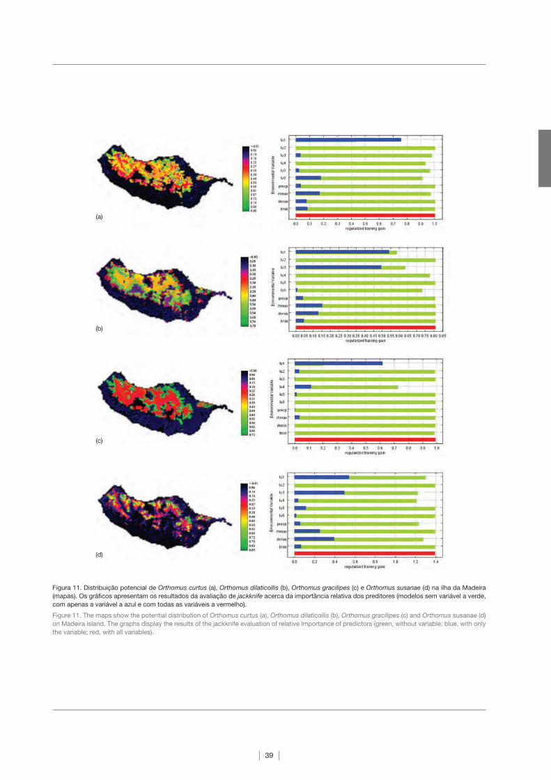
Figura 11. Distribuição potencial de Orthomus curtus (a), Orthomus dilaticollis (b), Orthomus gracilipes (c) e Orthomus susanae (d) na ilha da Madeira
(mapas). Os gráficos apresentam os resultados da avaliação de jackknife acerca da importância relativa dos preditores (modelos sem variável a verde,
com apenas a variável a azul e com todas as variáveis a vermelho).
Figure 11. The maps show the potential distribution of Orthomus curtus (a), Orthomus dilaticollis (b), Orthomus gracilipes (c) and Orthomus susanae (d)
on Madeira island. The graphs display the results of the jackknife evaluation of relative importance of predictors (green, without variable; blue, with only
the variable; red, with all variables).
(a)
(b)
(c)
(d)

40
Figura 12. Distribuição potencial de Gonepteryx maderensis (a) e Hipparchia maderensis (b) na ilha da Madeira (mapas). Os gráficos apresentam os
resultados da avaliação de jackknife acerca da importância relativa dos preditores (modelos sem variável a verde, com apenas uma variável a azul e
com todas as variáveis a vermelho).
Figure 12. The maps show the potential distribution of Gonepteryx maderensis (a) and Hipparchia maderensis (b) on Madeira Island. The graphs display
the results of the jackknife evaluation of relative importance of predictors (green, without variable; blue, with only the variable; red, with all variables).
Figura 13. Distribuição potencial de Anthus berthelotii madeirensis (a), Carduelis cannabina guentheri (b) e Carduelis chloris (c) na ilha da Madeira
(mapas). Os gráficos apresentam os resultados da avaliação de jackknife acerca da importância relativa dos preditores (modelos sem variável a verde,
com apenas a variável a azul e com todas as variáveis a vermelho).
Figure 13. The maps show the potential distribution of Anthus berthelotii madeirensis (a), Carduelis cannabina guentheri (b) and Carduelis chloris (c) on
Madeira Island. The graphs display the results of the jackknife evaluation of relative importance of predictors (green, without variable; blue, with only
the variable; red, with all variables).
(a)
(b)
(b)
(a)
(c)

41
mico com grande diversidade em regiões altas da Amé-
rica do Sul.
– Porella inaequalis (Gottsche ex Steph.) Perss. (Porella-
ceae) (Fig. 2c) é uma espécie foliosa endémica rara.
Ocorre maioritariamente na encosta Norte das flores-
tas de Laurissilva na ilha da Madeira, a cerca de 900 m
de altitude acima do nível do mar, onde a precipitação
é superior a 3000 mm/ano e a humidade ao longo de
todo o ano é elevada (75 -90%). A espécie cresce em
vales profundos, nas encostas sombreadas ao longo de
pequenos cursos de água, formando tapetes descontí-
nuos. É também encontrada com menos frequência na
casca de árvores endémicas. Como a espécie apenas
ocorre em áreas bem preservadas de floresta Laurissil-
va, a maior parte das plantas que ocorrem na proximi-
dade são endemismos de grande interesse, tal como o
feto arbóreo Culcita macrocarpa e os arbustos endémi-
cos Musschia wollastonii e Isoplexis sceptrum. Também
é frequente encontrar a espécie P. inaequalis associada
a outros briófitos endémicos, nomeadamente os mus-
gos Echinodium setigerum e E. spinosum, e a hepática
Tylimanthus maderensis. Também já foi encontrada as-
sociada às espécies de briófitos Saccogyna viticulosa,
Plagiochila exigua e Porella canariensis. A distribuição
da espécie está restrita à ilha da Madeira.
Plantas vasculares
As duas espécies de plantas vasculares consideradas
neste estudo foram seleccionadas tendo em conta o seu
estatuto de colonização e de protecção, ambas endémi-
cas e incluídas na Directiva Habitats como prioritárias. Os
dados de distribuição das espécies foram obtidos pelo
Jardim Botânico da Madeira, através do projecto Life 99
Nat/P/6431 intitulado: “Conservação de espécies vegetais
prioritárias e raras da Madeira”.
– Chamaemeles coriacea Lindl. (Rosaceae). O Buxo -da-
-rocha (Fig. 3a) é um arbusto ramificado, perenifólio,
com folhas obovadas e coriáceas, que pode atingir a
altura de 4 m. Esta espécie é típica do Zambujal (Mayte-
no umbellatae -Oleetum maderensis), um tipo de floresta
indígena da Madeira, dominada pela Oliveira -brava (Olea
maderensis), presente do nível do mar até aos 200 m de
altitude na encosta Sul da ilha. A espécie C. coriacea
ocorre em falésias costeiras e em ravinas no interior das
ilhas da Madeira, Porto Santo e Desertas.
– Convolvulus massonii F.Dietr. (Convolvulaceae). A Cor-
riola (Fig. 3b) é uma espécie arbustiva, perenifólia,, tre-
padeira,, ramificada, que pode atingir 4 m de altura.
Esta liana é típica da Laurissilva do Barbusano (Semele
androgynae -Apollonietum barbujanae), floresta medi-
terrânica dominada pelo Loureiro (Laurus novocana-
riensis) e pelo Barbusano (Apollonias barbujana), com
distribuição potencial entre os 300 e os 800 m de alti-
tude na costa Sul e na costa Norte entre os 50 e 450 m
de altitude. Esta espécie também ocorre em áreas de
Zambujal.
ra Island at 900 m.a.s.l., where the rainfall is greater than
3,000 mm per year and the humidity level is high during the
entire year (75 -90%). The species grows in deep valleys,
on the shaded slopes located along -side rivulets, forming
scattered mats. In rare instances, it can be found on the
bark of endemic trees. As it only exists in well -preserved
areas of Laurisilva, most of the plants growing in the vici-
nity are endemics such as the rare tree fern Culcita macro-
carpa and the endemic bushes Musschia wollastonii and
Isoplexis sceptrum. Porella inaequalis, is also frequently
found in the presence of other endemic bryophytes such
as the mosses Echinodium setigerum and E. spinosum
and the liverwort Tylimanthus maderensis. It has also been
found associated with Saccogyna viticulosa, Plagiochila
exigua and Porella canariensis. The species’ distribution is
restricted to Madeira Island.
Vascular plants
Two vascular plant species were selected based on their
degree of endemism and protection status, both species
are endemic and included in the European Habitats Directi-
ve. Distribution data was collected by the Botanical Garden
of Madeira Island, funded by the grant Life 99 Nat/P/6431
– “Conservation of rare and priority plant species from Ma-
deira Island”.
– Chamaemeles coriacea Lindl. (Rosaceae). Common
name – Buxo -da -rocha. (Fig. 3a). This branched evergre-
en shrub that grows up to 4 m tall, with spoon -shaped,
coriaceous leaves. This species is typical of the indige-
nous forest of Madeira Island, the “zambujal” (Mayteno
umbellatae -Oleetum maderensis), which is dominated by
wild olive (Olea maderensis), and found between 0 and
200 m on the southern coast. This species inhabits co-
astal rocky cliffs and inland ravines on Madeira, Porto
Santo and Desertas islands.
– Convolvulus massonii F.Dietr. (Convolvulaceae). Com-
mon name – Madeira Morning Glory, Corriola (Fig. 3b).
This is a perennial climbing shrub with branched stems
that can grow more than 4 m long. This liana is typi-
cal of the Barbusano Laurisilva (Semele androgynae-
-Apollonietum barbujanae), a Mediterranean Laurisilva
dominated by the Canary Laurel (Apollonias barbu-
jana) and the Laurel tree (Laurus novocanariensis). Its
potential distribution ranges between 300 and 800
m altitude on the southern coast and between 50
and 450 m altitude on the northern coast. This Con-
volvulaceae species is also found in zambujal areas.

42
Moluscos
A selecção das espécies de moluscos terrestres para este
estudo teve em conta o tipo de colonização (todas endémi-
cas), a distribuição, a morfologia (tamanho da espécie, pre-
sença/ausência de concha e forma da concha) e a exactidão
dos dados de distribuição das espécies. O principal objecti-
vo foi seleccionar um grupo de espécies distintas entre si no
que diz respeito aos habitats ocupados e às características
morfológicas, que poderão reflectir diferentes requisitos nas
condições ambientais das espécies. Foram então seleccio-
nadas três espécies endémicas da ilha da Madeira: Craspe-
dopoma mucronatum (Menke, 1830), Leptaxis groviana gro-
viana (Férussac, 1832) e Plutonia marcida (Gould, 1847).
– Craspedopoma mucronatum (Menke, 1830) (Cyclo-
phoridae) (Fig. 4a) está comummente associada a ha-
bitats de floresta, mas pode também ocorrer nas zonas
costeiras a norte e a sul da ilha da Madeira. A concha é
cuneiforme (em forma de cunha), podendo atingir até 7
mm de diâmetro.
– Leptaxis groviana groviana (Férussac, 1832) (Hygromii-
dae) (Fig. 4b) ocorre frequentemente na costa Sul da ilha,
desde o nível do mar até aos 400 m de altitude. Está as-
sociada a terrenos agrícolas e outras áreas com interven-
ção humana. Tem uma concha com uma forma discóide e
achatada, com um diâmetro de aproximadamente 22 mm.
– Plutonia marcida (Gould, 1847) (Vitrinidae) (Fig. 4c) é
típico de áreas húmidas na floresta Laurissilva. A con-
cha, brilhante e transparente, tem uma forma discóide e
achatada, com um diâmetro de 5 a 7 mm.
Carabídeos (Insecta, Coleoptera)
A ilha da Madeira apresenta uma fauna de carabídeos
rica, com um grande número de espécies endémicas (Ma-
chado 1995; Serrano & Boieiro 2008). Este grupo de es-
caravelhos é frequentemente escolhido para estudos de
ecologia e conservação, uma vez que reúne muitos dos
atributos que caracterizam um grupo indicador eficaz (Rai-
nio & Niemela 2003; Pearce & Venier 2006).
Os carabídeos da Madeira são um grupo de escaravelhos
da sub -ordem Adephaga, acerca do qual se tem um bom
nível de conhecimento faunístico. Este facto permite -nos a
interpretação e a discussão dos resultados obtidos através
da modelação da distribuição de espécies do grupo. Para
este estudo, seleccionámos quatro espécies endémicas do
género Orthomus, todas elas associadas à floresta Laurissil-
va, mas variando nos seus requisitos ecológicos. Duas das
espécies, O. curtus e O. gracilipes, têm uma ampla distribui-
ção na Laurissilva, enquanto a espécie O. dilaticollis é este-
notópica e ocorre em áreas de maior altitude. O. dilaticollis
também ocorre em áreas onde outras espécies do género
estão presentes. A nova espécie O. susanae n.sp. foi des-
coberta recentemente e está neste momento a ser descrita
por dois dos autores deste estudo (Serrano et al. subm.).
Com a selecção destas espécies pretende -se entender os
factores ambientais que limitam a distribuição das espé-
Molluscs
The selection of terrestrial molluscs was based on their
endemism, distribution, morphology (size of the specimen,
presence/absence of a shell and its shape) and accuracy
of the distribution data. The main objective was to select
a group of species distinctive in relation to their habitats
and morphological characteristics, which may influence
the environmental conditions that they can handle. Three
species, all of them endemic to Madeira Island, were thus
selected: Craspedopoma mucronatum (Menke, 1830), Lep-
taxis groviana groviana (Férussac, 1832) and Plutonia mar-
cida (Gould, 1847).
– Craspedopoma mucronatum (Menke, 1830) (Cyclo-
phoridae) (Fig. 4a) is commonly associated with forest
habitats, but may also occur in the northern and sou-
thern coastal areas of Madeira Island. The shell of this
species is cuneiform (wedge -shaped) with up to 7 mm in
diameter.
– Leptaxis groviana groviana (Férussac, 1832) (Hygro-
miidae) (Fig. 4b) usually occurs on the south coast of the
island between sea level up to 400 m.a.s.l., associated
with agricultural lands or other human managed areas.
It has a discoid and depressed shell with a diameter of
approximately 22 mm.
– Plutonia marcida (Gould, 1847) (Vitrinidae) (Fig. 4c) is
typical of humid areas in the Laurisilva forest. The shell
has a discoid and depressed shape, a diameter of 5 to 7
mm and is shiny and transparent.
Ground beetles (Insecta, Coleoptera)
The ground beetle Fauna of Madeira is relatively rich
and presents a high number of endemic species (Macha-
do 1995; Serrano & Boieiro 2008). This group of beetles is
frequently selected for ecological and conservation studies
since it fulfils many of the criteria of effective indicator taxa
(Rainio & Niemela 2003; Pearce & Venier 2006).
Madeiran ground beetles are a group of adephagan
Coleoptera about which we have a good amount of fau-
nistic knowledge. This solid faunistic knowledge allows
us to interpret and comment on the results achieved by
modelling the distribution of a particular species. We have
selected four endemic Orthomus species as study orga-
nisms, all of them highly associated with Laurisilva, but
differing somewhat on their ecological requisites. Two
of the species (O. curtus and O. gracilipes) are relatively
widespread in the Laurisilva forests while O. dilaticollis is
more stenotopic, being located at a higher altitude, but
also co -occurring with other congeners in some localities.
Orthomus susanae n. sp., was recently discovered and has
been formally described by two of the authors (Serrano et
al. subm.). By selecting these species we intend to explore
the environmental factors that constrain their distribution,
shedding some light on the factors affecting their distribu-
tion pattern. Additionally, by modelling the distribution of

43
cies e elucidar acerca das razões que explicam o padrão
de distribuição. Por outro lado, a modelação da distribuição
de espécies descobertas recentemente permite direccionar
esforços de amostragem e de investigação para áreas onde
a ocorrência desta espécie é altamente provável, e, assim,
melhorar a informação acerca da sua biologia e do seu es-
tatuto de conservação. Apesar das limitações das técnicas
existentes, acreditamos que os resultados obtidos através
da modelação preditiva de distribuição poderão ser de
grande utilidade para o nosso trabalho de investigação.
Os dados de distribuição de espécies utilizados nesta
modelação foram reunidos durante o ano de 2006 (de 22
de Maio a 9 de Junho) como resultado da implementação
de um projecto acerca da biodiversidade de artrópodes ter-
restres da ilha da Madeira, financiado pela Fundação para
a Ciência e a Tecnologia (PDCT/BIA -BDE/59202/2004). Fo-
ram amostrados 26 locais na Laurissilva, utilizando 30 ar-
madilhas de pitfall por local (mantidas no campo durante 15
dias). A ocorrência das espécies de Orthomus foi registada
com base em sistemas de geo -referenciação e os dados
posteriormente usados para o processo de interpolação.
Evitámos o uso de dados históricos de distribuição de es-
pécies, uma vez que os habitats naturais da ilha da Madeira
sofreram mudanças drásticas nas últimas décadas, levan-
do provavelmente à extinção de muitas das populações de
insectos associadas a esses habitats.
– Orthomus curtus (Wollaston, 1854) (Carabidae) (Fig. 5a)
é uma espécie estritamente associada ao solo da Lauris-
silva e que pode ser encontrada debaixo de pedras ou
na manta morta. Tal como as outras espécies do mesmo
género, é uma espécie predadora polífaga, que se ali-
menta de uma grande variedade de micro -artrópodes.
Ocorre em quase todos os fragmentos de Laurissilva e,
quando em simpatria, é geralmente mais abundante do
que as suas congéneres.
– Orthomus dilaticollis (Wollaston, 1854) (Carabidae) (Fig.
5b) parece ter uma distribuição mais restringida do que
O. curtus e O. gracilipes, e pode ser encontrada em zo-
nas mais altas do que as suas congéneres. Ocorre pre-
dominantemente na parte ocidental da ilha e foi encon-
trada, em alguns locais, em simpatria com O. curtus, O.
gracilipes ou O. susanae. Não há registos da presença
desta espécie nos fragmentos orientais de Laurissilva na
ilha da Madeira.
– Orthomus gracilipes (Wollaston, 1854) (Carabidae) (Fig.
5c) está também associada à Laurissilva, onde parece
ter uma ampla distribuição, apesar da sua ausência nos
fragmentos mais orientais. Em alguns locais, Orthomus
gracilipes ocorre juntamente com O. dilaticollis e/ou O.
curtus, apresentando geralmente uma abundância menor
do que O. curtus.
– Orthomus susanae Serrano & Borges, n. sp. (Carabidae)
(Fig. 5d) parece ser uma espécie mais críptica do que as
suas congéneres e é actualmente conhecida no Fanal,
onde ocorre com grande abundância, e Ribeiro Bonito,
onde parece ser rara. No Fanal, co -ocorre com O. cur-
tus, a baixa altitude, e com O. dilaticollis, a maior altitude.
a recently discovered species it is possible to focus rese-
arch efforts on specific areas where the occurrence of this
species is highly probable, allowing us to improve our data
on its biology and conservation status. Despite the limita-
tions of these techniques, we believe that our research will
benefit from the results obtained by predictive distribution
modelling.
The data used in the simulation was gathered during
2006 (between May 22nd and June 9th) as part of a re-
search project on the biodiversity of Madeiran terrestrial
arthropods financed by the Fundação para a Ciência e a
Tecnologia (PDCT/BIA -BDE/59202/2004). Twenty -six sites
were sampled by means of pitfall trapping within the area
of Laurisilva (30 traps/site, with traps active for 15 days).
The localities where the selected Orthomus species occur-
red were recorded by means of geopositioning systems
and then used for the interpolation process. We avoided
the use of historical data because some of the Madeiran
natural habitats suffered drastic changes in the last de-
cades, probably leading to the extinction of many of the
associated insect populations.
– Orthomus curtus (Wollaston, 1854) (Carabidae) (Fig. 5a)
is a species strictly associated with the underground of
the Laurisilva where it can be found beneath stones or in
the forest litter. Like the other species of this genus, it is
a polyphagous predator feeding on a diversity of micro-
arthropods. It occurs in most of the fragments of Laurisil-
va and, when in sympatry, it is generally more abundant
than its congeners.
– Orthomus dilaticollis (Wollaston, 1854) (Carabidae)
(Fig. 5b) seems more localized than both O. curtus and
O. gracilipes, and can be found at higher altitudes than its
congeners. It occurs predominantly in the western part of
the island and in some sites was found in sympatry with
O. curtus, O. gracilipes or O. susanae. There are no re-
cords of this species from the most eastern fragments of
Laurisilva.
– Orthomus gracilipes (Wollaston, 1854) (Carabidae) (Fig.
5c) is also associated with Laurisilva, where it appears to
be relatively widespread, despite its absence from the
most eastern forest fragments. In some locations, Ortho-
mus gracilipes co -occurs with both O. dilaticollis and/or
O. curtus, usually presenting lower abundance than its
latter congener.
– Orthomus susanae Serrano & Borges n. sp. (Carabi-
dae) (Fig. 5d) appears to be more cryptic than its conge-
ners and is presently known to exist in Fanal, where it is
very abundant, and Ribeiro Bonito, where it seems rare.
In Fanal, the species co -occurs with O. curtus at lower
altitudes and with O. dilaticollis at higher altitudes.

44
Borboletas (Insecta, Lepidoptera)
Existem três espécies e duas subespécies endémicas de
borboletas na ilha da Madeira. As duas espécies endémicas
seleccionadas para este estudo, ambas desempenhando
um papel muito importante nos ecossistemas, apresentam
diferenças significativas nas abundâncias e nos habitats pre-
ferenciais onde ocorrem (Wakeham -Dawson et al. 2002).
– Gonepteryx maderensis Felder, 1862 (Pieridae) (Fig. 6a).
Segundo dados publicados e registos dos autores deste
estudo, esta espécie está associada à copa da floresta
húmida de Laurissilva. Existem poucos registos da pre-
sença desta espécie fora da área de distribuição da Lau-
rissilva e os indivíduos pontuais encontrados noutros ha-
bitats devem ter sido provavelmente levados por ventos
fortes. É frequente observar adultos desta espécie a voar
de Fevereiro a Setembro, entre os 300 e os 1700 m de
altitude. Não é uma espécie rara, mas pode -se dizer que
é tão pouco frequente como a única espécie de planta da
qual se alimenta, o sanguinho da Macaronésia.
– Hipparchia maderensis (Bethune -Baker, 1891) (Nym-
phalidae) (Fig. 6b). Os registos disponíveis sobre esta
espécie indicam que ocorre em qualquer altitude, mas é
particularmente comum em áreas acima dos 1000 m. As
lagartas alimentam -se de várias espécies de Poaceae.
É frequente observar muitos indivíduos adultos no gran-
de planalto da ilha da Madeira, Paúl da Serra, desde o
fim da Primavera até ao fim do Verão.
Aves
A selecção dos taxa de aves a considerar para este estu-
do foi feita com base no tipo de colonização, na sua distri-
buição, no tipo e área de habitat disponível, na abundância
e na exactidão dos dados das espécies. Os dados de distri-
buição utilizados nos modelos são o resultado de um traba-
lho de campo muito exaustivo, que se desenvolveu durante
a época de nidificação, de Fevereiro a Julho, durante os
anos de 1999 a 2002. Foram realizados 90 transectos de
2 horas cada, segundo uma grelha geo -referenciada (UTM)
de 2×2 km (para mais detalhes ver Oliveira & Menezes
2004). Espera -se que os modelos preditivos de distribui-
ção ajudem a explicar as razões que levam a uma presença
quase exclusiva de subespécies endémicas raras em áreas
com uma forte influência humana (directa ou indirecta), tais
como áreas de floresta exótica, áreas agrícolas e habitats
naturais perturbados.
– Anthus berthelotii Bolle, 1862 (Motacillidae) (Fig. 7a), co-
nhecida como Corre -caminhos, é uma espécie endémica
da Macaronésia, que ocorre exclusivamente nos arquipé-
lagos da Madeira e das Canárias e que compreende duas
subespécies: A. b. madeirensis e A. b. berthelotii. Anthus
berthelotii madeirensis (Erlanger, 1899) está apenas pre-
sente na ilha da Madeira, onde apresenta uma distribui-
ção fragmentada, com preferência para terrenos rochosos
e de baldio, em áreas abertas, a qualquer altitude.
– Carduelis chloris Linnaeus, 1758 (Fringillidae) (Fig. 7b)
Butterflies (Insecta, Lepidoptera)
There are three endemic species and two endemic subs-
pecies of butterflies on Madeira Island. The two endemic
species selected, both equally important in their ecosyste-
ms, show considerable differences in terms of abundance
and preferred habitats (Wakeham -Dawson et al. 2002).
– Gonepteryx maderensis Felder, 1862 (Pieridae) (Fig. 6a),
known as the Madeiran Brimstone, is intimately associa-
ted with the humid Laurisilva forest canopy, as indicated
in our own records and other publications. Very few re-
cords fall outside the Laurisilva distribution area and the-
se few records are probably isolated specimens driven
out of their habitats by strong winds. Adults have been
seen flying from February thru September, between 300
and 1,700 m.a.s.l. The Madeiran Brimstone is not a rare
species but can be considered scarce since it only has
one known food -plant, the Macaronesian Buckthorn.
– Hipparchia maderensis (Bethune -Baker, 1891) (Nym-
phalidae) (Fig. 6b) is commonly known as the Madeiran
Grayling. The records indicate that it can be found at
almost all altitudes, but it is fairly common above 1,000
m.a.s.l. where its preferred habitat is located, and its ca-
terpillars feed on several species of Poaceae. One of the
best places to observe this endemic nymphalid butterfly is
at the top of the island’s only large plateau, Paúl da Serra,
where hundreds of individuals can be seen flying from late
spring throughout the summer.
Birds
The selection of bird taxa used for this analysis was ba-
sed on their degree of endemism, patchy distribution, type
and area of available habitat, low abundance and quality
of data. The data used in the simulations are the result of
extensive fieldwork, which took place during the nesting
seasons, February to July, from 1999 to 2002. Ninety tran-
sects of 2 hours were performed along a georeferenced grid
(UTM) of 2×2 km (for further details see Oliveira & Menezes
2004). It is expected that the predictive distribution models
will help explain the factors that dictate the almost exclusive
presence of uncommon endemic subspecies in areas with
a strong direct or indirect human influence (exotic forest,
farmland and disturbed natural habitats).
– Anthus berthelotii Bolle, 1862 (Motacillidae) (Fig. 7a),
known as the Berthelot’s pipit (Corre -caminhos), is a
species endemic to Macaronesia, occurring exclusively
on the archipelagos of Madeira and the Canary Islands,
and is comprised of two subspecies: A. b. madeirensis
and A. b. berthelotii. Anthus berthelotii madeirensis (Er-
langer, 1899) can be found only on Madeira Island, where
it has a patchy distribution, favouring rocky, open and
scrubby terrain at all altitudes.
– Carduelis chloris Linnaeus, 1758 (Fringillidae) (Fig. 7b),
known as the Greenfinch (Verdilhão), is a native species
of Madeira Island. It favours areas of exotic forest, mixed
forest near farmland and/or open patchy scrub areas. It

45
conhecida como Verdilhão, é uma espécie nativa da ilha
da Madeira. Tem preferência por áreas de floresta exóti-
ca, floresta mista próxima de áreas agrícolas e/ou áreas
de baldio abertas. Pode também ser encontrada em áre-
as urbanas.
– Carduelis cannabina guentheri Wolters, 1953 (Frin-
gillidae) (Fig. 7c), conhecida como Pintarroxo, é uma
subespécie endémica das ilhas da Madeira e de Porto
Santo. Ocorre preferencialmente em áreas com gramíne-
as e com alguns arbustos. Também está frequentemente
presente em áreas agrícolas e pode ocasionalmente ser
encontrada em jardins e em sítios humanizados.
4.2. As variáveis preditoras
Para modelar a distribuição das espécies, utilizámos
variáveis climáticas e de uso do solo. Todos os mapas fo-
ram redimensionados para a resolução mínima dos dados
disponíveis de presença de espécies, ou seja, 500×500 m;
excepto para a modelação das aves, para as quais se usou
uma resolução de 2×2 km:
a) os dados climáticos foram obtidos pelo modelo CIELO
(Clima Insular à Escala Local), desenvolvido por Azevedo
(1996). O CIELO é um modelo de base física que simula
as variáveis climáticas numa ilha usando dados de uma
única estação meteorológica de referência (ver Azeve-
do 1996 e Azevedo et al. 1999). A estação de referência
“conhece” a sua posição no contexto da orografia e do
regime da dinâmica atmosférica e controla o modelo a
partir desse ponto. Como fronteira é utilizada uma co-
bertura “raster” proveniente de um modelo digital do
terreno (MDT) no âmbito de um Sistema de Informação
Geográfica. O modelo é forçado com a climatologia à
escala regional. Os processos são simulados de acordo
com a orientação e a direcção da circulação das massas
de ar. O modelo consiste em dois submodelos, um que
simula os processos advectivos (transferência espacial
de propriedades físicas do ar em movimento), outro para
fins de radiação solar e balanço de energia. A compo-
nente de simulação da advecção tem como base o efeito
de Föhen para reproduzir os processos termodinâmicos
que ocorrem no seio de uma massa de ar quando esta
é obrigada a transpor o obstáculo orográfico (ilha). Os
processos termodinâmicos são modelados da seguinte
forma: inicialmente, uma coluna de ar húmida, com uma
determinada temperatura (T1) e humidade relativa (HR1),
é forçada a ascender a barlavento das ilhas, percorrendo
a mesma segundo a direcção e sentido do vento; no per-
curso da subida, a temperatura da coluna de ar diminui e
o ar satura (são considerados os gradientes adiabáticos
seco e saturado), com a consequente condensação de
vapor de água na coluna; sob condições físicas favorá-
veis, uma fracção de água na forma líquida precipita; a
sotavento da ilha, a massa de ar adquire uma humidade
relativa (HR2) inferior a HR1 e uma temperatura (T2) su-
perior a T1. Aos montantes de precipitação modelado
pelo CIELO, designados por precipitação orográfica,
can also be seen in urban centres.
– Carduelis cannabina guentheri Wolters, 1953 (Frin-
gillidae) (Fig. 7c), known as the Linnet (Pintarroxo), is an
endemic subspecies of the Madeira and Porto Santo is-
lands. It favours areas dominated by graminae and with
some shrubs. It occurs frequently in agricultural areas,
and can occasionally be seen in gardens and humanized
places.
4.2. The predictors
We used climatic and land -use variables to model the
distribution of species. All maps were resized to the mini-
mum resolution of presence data, i.e., 500×500 m (except
for birds, where the resolution used was 2×2 km):
a) Climate data were obtained from the CIELO Model de-
veloped by Azevedo (1996). The model CIELO (acronym
for "Clima Insular à Escala Local”) is a physically based
model that simulates the climatic variables for an island
using data from a single synoptic reference meteorologi-
cal station (see Azevedo 1996 and Azevedo et al. 1999).
The reference station “knows” its position in the orogra-
phic and dynamic regime context and controls the mo-
del on that position. The domain of computation is a GIS
raster grid parameterized with a digital elevation model
(DEM). The process is adjusted following the direction
of the circulation of air masses. The model consists of
two main sub -models, one for the advective processes
simulation and another for solar radiation and energy
balance purposes. The advective component simulation
assumes the Föhen effect to reproduce the dynamic and
thermodynamic processes occurring when an air mass
moves through the island’s orographic obstacle. The
processes modelled are as follows: initially a moist air
column over the ocean, with temperature T1 and relati-
ve humidity RH1, is forced to ascend the upstream side
of the island’s topography in the wind direction; during
the ascending path, the column’s temperature decreases
and the air saturates (both dry and saturated adiabatic
lapse rates are assumed), with the consequent conden-
sation of water vapour in the column; in favourable phy-
sical conditions, a fraction of the liquid water contents
precipitates; on the lee side of the island, the air mass
acquires a relative humidity RH2<RH1 and a temperature
T2>T1, characteristic of the Föhen effect. The described
precipitation process modelled in CIELO is designated by
orographic precipitation. The calibration of CIELO requires
the adjustment of two parameters (α and β) that govern the
efficiency of the precipitation processes. The CIELO model
has been calibrated and validated for Madeira Island (see
Santos et al. 2004), and is now available through CLIMAAT
and CLIMARCOST projects (Interreg_IIIB, MAC 2.3/A3
and 05/Mac/2.3/A1; Azevedo 2003, 2006). The variables

46
são acrescidos os observados na estação de referência,
considerados como provenientes de outros processos. A
calibração do CIELO requer o ajuste de dois parâmetros
(α e β) responsáveis pela eficiência e assimetria dos pro-
cessos de precipitação. O modelo CIELO foi calibrado e
validado para a ilha da Madeira (ver Santos et al. 2004 e
Tomé 2007) e está actualmente disponível através dos
projectos CLIMAAT e CLIMARCOST (Interreg_IIIB, MAC
2.3/A3 e 05/Mac/2.3/A1; Azevedo 2003, 2006). Foram
seleccionadas as variáveis de humidade relativa máxima
(hrmax), humidade relativa mínima (hrmin), temperatura
anual mínima (tmin) e precipitação anual total (precp).
Das variáveis disponíveis, foram estas que apresentaram
um menor valor de correlação cruzada e as que se acre-
dita serem mais importantes na limitação da distribuição
da maior parte das espécies.
b) Os dados de uso do solo foram obtidos de Anónimo
(1991). Foram consideradas cinco variáveis: presença de
vegetação nativa (lu1), presença de vegetação exótica
(lu2), presença de terrenos agrícolas (lu3), presença de
vegetação mista (nativa e exótica) (lu4), presença de área
social (lu5), e presença de pastagem natural (lu6). Para
as aves, em vez de dados de presença de um tipo de
solo, foi utilizado o número de pixéis de 10×10 m presen-
tes numa grelha de 2×2 km.
4.3. O processo de modelação
Com base na nossa experiência, foram utilizados os pa-
râmetros de base do Maxent e factores lineares e quadrá-
ticos de forma a evitar sobrestimação. Também se utilizou
o jackknife para estimar a importância relativa de cada vari-
ável na determinação da distribuição potencial de uma es-
pécie. Para isso, cada variável foi excluída isoladamente e
foi criado um modelo com as restantes variáveis. Foi depois
criado um modelo usando cada variável isolada e outro mo-
delo utilizando todas as variáveis. Não foi possível avaliar a
exactidão das predições do modelo, dado o pequeno nú-
mero de amostras disponíveis para cada espécie.
4.4. Resultados
Briófitos
Exormotheca pustulosa (Fig. 8a)
Os resultados dos modelos preditivos de distribuição de
Exormotheca pustulosa estão de acordo com o conhecimen-
to actual que se tem da biologia da espécie. A análise con-
firma que a espécie ocorre maioritariamente a baixa altitude
e em áreas com influência climática mediterrânica. Segundo
Bischler (2004), a espécie cresce em áreas com uma precipi-
tação média anual entre os 600 e os 700 mm, desde o nível
do mar até aos 200 m de altitude, em toda a região Medi-
terrânica. E, de facto, o défice de precipitação determina a
distribuição actual e predita da espécie na ilha da Madeira,
ocorrendo maioritariamente em áreas com clima mediterrâ-
nico temperado e em substratos húmidos no Inverno e muito
extracted were maximum relative humidity (RHmax),
minimum relative humidity (RHmin), minimum annual
temperature (Tmin) and total annual precipitation (Pre-
cp). From the available variables, these were the ones
showing the lowest inter -correlation values and, based
on expert knowledge, thought to be the most important
factors limiting the distribution of most species.
b) Land -use data were obtained from Anónimo (1991). Five
variables were extracted: presence of native vegetation
(lu1), presence of exotic vegetation (lu2), presence of
agricultural land (lu3), presence of mixed vegetation (na-
tive and exotic) (lu4), presence of social areas (lu5), and
presence of natural grasslands (lu6). For birds, instead of
presence, the amount of 10×10 m pixels present in each
2×2 km pixel was used.
4.3. The modelling process
We used default Maxent parameters and only linear and
quadratic factor types in order to avoid over fitting, accor-
ding to our previous experience. A jackknife procedure was
run to estimate the relative importance of each variable in
determining the potential distribution of the species. Here,
each variable was excluded in turn, and a model was crea-
ted with the remaining variables. Then a model was created
using each variable in isolation. Additionally, a model was
created using all variables. Because of low sample sizes,
no evaluation of the accuracy of model predictions could
be performed.
4.4. Results
Bryophytes
Exormotheca pustulosa (Fig. 8a)
Predictive model results agree with current knowledge of
the biology of this species. The analysis confirms that Exor-
motheca pustulosa mainly occurs at low altitudes and areas
of Mediterranean influence. According to Bischler (2004),
this species grows in areas with a mean annual rainfall of
between 600 and 700 mm and within an altitudinal range of
0 -200 m.a.s.l. in the entire Mediterranean region. The pre-
cipitation deficit determines the actual and predicted distri-
bution of the species in Madeira, occurring mainly in areas
of Mediterranean temperate and thermophitic climates: hu-
mid substrate in winter and very dry in summer. The predic-
ted map identifies the areas of known species occurrence

47
secos no Verão. O mapa de distribuição potencial identifica
áreas onde a espécie ocorre e algumas outras áreas onde
poderia estar presente. As áreas adequadas para a ocor-
rência da espécie (representadas a verde no mapa) ocorrem
maioritariamente no Sul da ilha. No Norte, são raras as áre-
as com condições favoráveis, estando a espécie confinada
a pequenas áreas em falésias expostas. Actualmente, não
existem muitos dados de ocorrência da espécie nestas áreas
escarpadas, o que pode ser devido devido à falta de amos-
tragem nestes locais ou devido a pressão urbanística.
Plagiochila stricta (Fig. 8b)
O género Plagiochila é característico da brioflora da Ma-
deira, apresentando um grande número de espécies e uma
distribuição muito grande em diferentes habitats. Algum
trabalho de campo realizado recentemente revelou que as
espécies deste género apresentam uma frequência eleva-
da na floresta Laurissilva, sobretudo em encostas e rochas,
mas também na casca de diferentes árvores. O resultado
da modelação da distribuição para a espécie P. stricta, ten-
do em conta a bibliografia disponível e outros trabalhos não
publicados, identificou várias áreas dentro de fragmentos de
Laurissilva onde a presença da espécie é provável. O modelo
revela também uma grande probabilidade de ocorrência da
espécie em algumas áreas da parte oriental da ilha, tais como
Achadas da Cruz e Faial. A adequabilidade prevista para a
espécie de áreas na parte sudoeste da Madeira não está, na
nossa opinião, correcta, uma vez que a espécie é sensível a
parâmetros microambientais que não foram considerados no
processo de modelação. Na verdade, na parte sudoeste da
ilha, P. stricta ocorre apenas em vales abrigados de alguns
fragmentos isolados de Laurissilva. A espécie também está
ausente em áreas favoráveis mais a Sul, perto do Funchal,
provavelmente devido à grande influência antropogénica.
Porella inaequalis (Fig. 8c)
Os resultados da modelação da distribuição deste taxa
endémico estão, em geral, de acordo com o conhecimento
actual que se tem da espécie. No entanto, o modelo identi-
fica várias áreas de grande adequabilidade para a espécie
que não estão de acordo com os resultados dos estudos
que se têm vindo a desenvolver. De facto, essas áreas têm
sido amostradas por briólogos de forma intensiva durante
o último século, sem nunca se ter registado a presença da
espécie, conspícua, nesses locais. Contudo, alguns desses
locais são de difícil acesso e os esforços de amostragem
para localizar a espécie deverão, no futuro, concentrar -se
nesses locais.
Plantas vasculares
Convolvulus massonii (Fig. 9a)
A distribuição de Convolvulus massonii parece ser in-
fluenciada pela temperatura, a humidade relativa e a pre-
cipitação. A espécie apresenta uma grande distribuição
potencial, tanto no Sul como no Norte da ilha, sobretudo
na zona costeira, coincidindo com a distribuição potencial
and also indicates other areas where they could be present.
Highly suitable areas (green in the figure) appear mainly at
the south of the island, and are scarcer in the north, where
the species might be confined to small patches on exposed
cliffs. The lack of data from these areas might be due to lack
of surveys in the highly exposed cliffs where the species
could potentially inhabit according to the predicted map or
to urbanization.
Plagiochila stricta (Fig. 8b)
Plagiochila is a characteristic genus of the Madeiran
bryoflora that shows a high biodiversity in terms of num-
ber of species and the colonization of different habitats.
Recent fieldwork revealed the high frequency of Pla-
giochila species in the Laurisilva, mainly on slopes and
rocks, but also on the bark of several trees. The result
of the distribution model for P. stricta identified several
areas within the Laurisilva patches where the presence
of this species is highly probable. Taking the published
data on its distribution and some unpublished data into
consideration, the model reveals a high probability of
occurrence of this species in areas at the eastern part
of the island (Achadas da Cruz and Faial). The species’
potential occurrence on the southwestern slope of Ma-
deira, as predicted by the model, is erroneous due to the
sensitivity of the taxon to several micro -environmental
parameters not considered in the modelling process. In
such areas, P. stricta occurs only in some isolated and
protected Laurisilva fragments located in sheltered val-
leys. Indeed, P. stricta is absent from the southernmost
suitable areas located near Funchal, probably because of
the high anthropogenic influence in the area.
Porella inaequalis (Fig. 8c)
Model output for this endemic species is, in general, in
accordance with current knowledge. However, the model
identifies several areas of high suitability for the species that
are not in accordance with the results of bryological studies.
Bryologists have intensively sampled these areas during the
last century, without revealing the presence of this conspi-
cuous species. However, some localities in those areas pre-
sent a rather inaccessible topography which complicates
the surveys. Future efforts to locate this endemic species
should concentrate there.
Vascular Plants
Convolvulus massonii (Fig. 9a)
The distribution of Convolvulus massonii seems to be
influenced by temperature, relative humidity and precipi-
tation. It shows a vast potential distribution, both on the
southern and northern parts of the island, particularly on
the coast, which overlaps the potential distribution of its

48
do seu habitat preferencial, a Laurissilva do Barbusano.
A maior parte da sua distribuição potencial na parte Sul da
ilha está sob grande influência humana, o que restringe a
espécie a pequenas áreas dispersas de Laurissilva do Bar-
busano, sobretudo em escarpas isoladas. É por isso que a
maior parte das populações de Convolvulus massonii são
encontradas no Norte da Madeira.
Chamaemeles coriacea (Fig. 9b)
Tendo em conta os resultados do modelo, a distribuição
de Chamaemeles coriacea parece ser influenciada directa-
mente pela precipitação, humidade relativa e temperatura.
Deste modo, a sua distribuição potencial cobre maioritaria-
mente áreas de baixa altitude no Sul da Madeira, onde a pre-
cipitação e a humidade relativa são mais baixas e as tempe-
raturas mínimas são mais altas do que no Centro e no Norte
da ilha. No entanto, a maior parte da área de distribuição
predita no Sul sofre grande pressão humana, o que restringe
a distribuição da espécie a escarpas inacessíveis.
Moluscos
Craspedopoma mucronatum (Fig. 10a)
Os resultados do modelo preditivo sugerem que a ocor-
rência de C. mucronatum pode ser influenciada directa-
mente por variáveis climáticas, em particular a precipitação
e a temperatura mínima. Apesar da espécie ser frequente
em habitats de floresta, parece estar bem adaptada a áreas
mais secas e quentes da ilha, com uma cobertura de vege-
tação diferente. O modelo de distribuição prediz também
que as zonas costeiras de toda a ilha, desde o nível do mar
até aos 300 m de altitude, podem ter condições ambientais
favoráveis para a ocorrência da espécie.
Leptaxis groviana groviana (Fig. 10b)
A distribuição de L. groviana groviana parece ser influen-
ciada por factores climáticos, em particular a precipitação
e a temperatura mínima. O modelo de distribuição prevê
a ocorrência da espécie em áreas com vegetação nativa
e áreas urbanas. É esperada a ocorrência de L. groviana
groviana em áreas urbanas, uma vez que a espécie está
actualmente bem adaptada a este tipo de habitats altera-
dos pelo Homem.
Plutonia marcida (Fig. 10c)
A distribuição de P. marcida parece ser influenciada ex-
clusivamente pelas quatro variáveis climáticas analisadas,
em particular, pela humidade relativa máxima e mínima.
Estes resultados devem -se à fisiologia típica da família Vi-
trinidae, que apresenta uma grande restrição nos níveis de
humidade suportáveis. De acordo com o modelo de dis-
tribuição, P. marcida pode ocupar uma grande parte das
áreas altas da ilha. Ao contrário do que seria esperado, a
variável da vegetação nativa não parece ter um efeito na
distribuição da espécie, o que indica que são necessários
mais estudos para validar os resultados obtidos pelo mo-
delo preditivo.
main habitat, the barbusano laurisilva. Most of its potential
distribution area on the southern part of the island is under
strong human influence, which limits the presence of this
species to small, dispersed spots of barbusano laurisilva
on remote cliffs. Consequently, most of the Convolvulus
massonii populations are found on the northern part of
Madeira.
Chamaemeles coriacea (Fig. 9b)
According to model results, the distribution of Chama-
emeles coriacea seems to be directly influenced by preci-
pitation, relative humidity and temperature. Therefore, its
potential distribution covers mainly low altitude areas of the
southern part of Madeira, where rainfall and relative humidi-
ty are lower and the minimum temperatures are higher that
those of the northern and central parts of the island. Howe-
ver, most of the potential distribution of this species on the
southern part of the island is under strong human pressure,
thereby limiting its presence to inaccessible cliffs.
Molluscs
Craspedopoma mucronatum (Fig. 10a)
The results of the predictive model suggest that C. mu-
cronatum may be directly influenced by climatic variables,
particularly by precipitation and minimum temperature. Al-
though commonly present in forest habitats, the species
seems to be well adapted to drier and warmer areas of the
island where there is distinct vegetation cover. The model
also predicts that the species might find adequate environ-
mental conditions on the coast between sea level and up to
300 m around the entire island.
Leptaxis groviana groviana (Fig. 10b)
The distribution of L. groviana groviana seems to be
mostly influenced by climatic factors, particularly precipi-
tation and minimum temperature. The distribution model
predicts the occurrence of this species in areas of native
vegetation and urban habitats. The occurrence of L. gro-
viana groviana in urban areas is to be expected since the
species is currently well adapted to this type of human-
-made habitats.
Plutonia marcida (Fig. 10c)
The distribution of P. marcida seems to be exclusively
influenced by the four climatic variables analysed, and, in
particular, by maximum and minimum relative humidity.
This is a result of the physiology of the species, which pre-
sents high restrictions to the humidity level, typical of the
Vitrinidae family. According to the distribution model, it is
expected that P. marcida will occupy higher altitudes on
the island. Contrary to what was expected, the native ve-
getation variable does not have an important effect on the
distribution of this species. This may indicate that further
studies are needed to validate the results obtained with the
predictive model.

49
Carabídeos (Coleoptera, Carabidae)
Os resultados dos modelos preditivos evidenciam algu-
mas diferenças nos padrões de distribuição das diferentes
espécies de Orthomus seleccionadas. Tendo em conta da-
dos de distribuição da espécie em trabalhos publicados e
também registos não publicados da colecção entomológica
de um dos autores deste estudo, é apresentada abaixo uma
breve análise dos resultados de modelação para cada taxa.
Orthomus curtus (Fig. 11a)
O modelo preditivo de distribuição para O. curtus iden-
tificou várias áreas isoladas dentro do habitat de Laurissil-
va onde a presença desta espécie é altamente provável.
Este resultado está de acordo com dados publicados de
distribuição da espécie para algumas áreas, como Chão
da Ribeira, Rabaçal, Serra de Água e Achada do Teixeira.
A elevada probabilidade de ocorrência da espécie em al-
gumas áreas na parte ocidental da ilha, tais como Achada
da Cruz e Santa Madalena, precisa de ser validada com
trabalho de campo, já que até à data não foram desenvolvi-
dos (que sejam do nosso conhecimento) estudos sistemá-
ticos nestas áreas. Apesar de os modelos de distribuição
apontarem como muito favoráveis para a ocorrência de O.
curtus as áreas a Sul da ilha (perto do Funchal), e apesar de
serem sítios frequentemente explorados, acreditamos que
essas áreas ao sofrerem uma grande perturbação humana
se tenham tornado inabitáveis para a espécie.
Orthomus dilaticollis (Fig. 11b)
A modelação da distribuição de O. dilaticollis identificou
um grande número de quadrados contíguos onde a pre-
sença da espécie é altamente provável. Este resultado não
está de acordo com o que os especialistas previam, uma
vez que a espécie parece ser mais estenotópica do que
as suas congéneres. A espécie é conhecida de algumas
áreas localizadas maioritariamente na parte ocidental da
ilha (Rabaçal, Caramujo, Risco, Chão da Ribeira), que fo-
ram identificadas claramente nos resultados de modelação.
No entanto, a presença desta espécie em algumas áreas
identificadas como sendo de ocorrência altamente prová-
vel (Ribeiro Frio, Cedro Gordo, Santo da Serra, Terreiro da
Luta, Funduras) é duvidosa. De facto, muitas dessas áreas
foram exaustivamente amostradas por entomólogos nas
últimas duas décadas, sem revelar a presença da espécie
conspícua.
Orthomus gracilipes (Fig. 11c)
Os resultados da modelação preditiva da distribuição de
O. gracilipes mostraram uma grande probabilidade de ocor-
rência da espécie em fragmentos isolados de Laurissilva,
alguns até de grandes dimensões. Alguns dos locais onde
se tem registado a presença de O. gracilipes (e.g. Fonte da
Pedra, Rabaçal, Fajã da Nogueira, Curral das Freiras, Quei-
madas, Terreiro da Luta) foram identificados nos modelos.
Noutras áreas consideradas pelo modelo como sendo de
grande probabilidade de ocorrência (Serra de Água, Por-
Ground beetles (Coleoptera, Carabidae)
The distribution models show some differences in the
distribution patterns of the selected Orthomus species.
A brief analysis of the modelling results is presented below,
taking into consideration the published data on the distribu-
tion of these species and the unpublished records from one
of the authors’ entomological collection.
Orthomus curtus (Fig. 11a)
The predictive distribution model for O. curtus identified
various isolated areas within the Laurisilva where the pre-
sence of this species is highly probable. In fact, this proved
to be true for some areas (Chão da Ribeira, Rabaçal, Serra
de Água, Achada do Teixeira) after comparing the model
results with published data on species distribution. The
high probability of occurrence of this species in some areas
at the western part of the island (Achada da Cruz, Santa
Madalena) needs to be confirmed with fieldwork since no
systematic study has been carried out there. In spite of the
high suitability spotted by model results, it seems that O.
curtus is absent from the southernmost areas near Funchal
since there is a high human disturbance in these localities,
and they have been frequently studied without revealing the
presence of this beetle species.
Orthomus dilaticollis (Fig. 11b)
The distribution modelling for O. dilaticollis identified a
large number of contiguous squares where the presence
of this species is highly probable. This result does not
agree with our expert -based predictions since this spe-
cies appears to be more stenotopic than its congeners.
O. dilaticollis is known from a few number of localities
most of which are located on the western part of the is-
land (Rabaçal, Caramujo, Risco, Chão da Ribeira), and
had been clearly identified in the model results. However,
the presence of this species in some of the areas iden-
tified as having a high probability of occurrence (Ribeiro
Frio, Cedro Gordo, Santo da Serra, Terreiro da Luta, Fun-
duras) is certainly elusive. Entomologists have intensively
sampled many of these areas during the two last deca-
des without revealing the presence of this conspicuous
species.
Orthomus gracilipes (Fig. 11c)
The results of predictive distribution modelling for O.
gracilipes showed a high probability of species occurren-
ce in some isolated Laurisilva fragments, several of which
of considerable size. Some of the sites where O. gracili-
pes is known to occur have been clearly identified in the
model results (e.g., Fonte da Pedra, Rabaçal, Fajã da No-
gueira, Curral das Freiras, Queimadas, Terreiro da Luta).
In other areas identified as having a high probability of
occurrence (Serra de Água, Portela, Santo da Serra and

50
tela, Santo da Serra e Funduras) não foi ainda registada
a presença da espécie; e nas áreas mais orientais, a sua
presença é pouco provável.
Orthomus susanae (Fig. 11d)
De acordo com os resultados do modelo preditivo, O.
susanae apresenta algumas populações pontuais na Ma-
deira, a maior parte no Norte da ilha. O modelo também
identificou a área que circunda Achada do Cedro Gordo
como uma das zonas com maior probabilidade de ocorrên-
cia da espécie, o que sugere que, de futuro, os trabalhos de
prospecção se deverão concentrar mais nessa área.
Em geral, os resultados da modelação identificaram cla-
ramente muitas das áreas de ocorrência actual das espé-
cies e indicam outros locais onde as espécies de Ortho-
mus poderão ser provavelmente encontradas. Em alguns
casos, no entanto, os modelos não são congruentes com
o presente conhecimento que temos acerca da biologia
das espécies. Por exemplo, os resultados obtidos com O.
dilaticollis (Fig. 11b), uma espécie estenotópica, não eram
expectáveis, sobretudo quando comparados com os resul-
tados obtidos com a sua congénere, amplamente distribuí-
da, O. curtus (Fig. 11a). A falta de exactidão nos resultados
para áreas específicas da floresta de Laurissilva reflectem
seguramente o facto de não se terem considerado como
preditoras algumas variáveis microambientais. De facto,
variáveis como o pH do solo, a humidade do solo ou a den-
sidade da manta morta são determinantes na distribuição
de escaravelhos e nem sempre estão correlacionadas com
as variáveis climáticas a grande escala. Por outro lado,
quando não se considera o papel dos factores históricos/
biogeográficos na predição da distribuição de Orthomus
spp., o modelo também indica várias áreas isoladas como
de grande probabilidade de ocorrência da espécie. Estas
áreas são o equivalente ao que se designa por ilhas eco-
lógicas, e, apesar de apresentarem condições ambientais
semelhantes às de outros locais onde as espécies de Or-
thomus efectivamente ocorrem, a sua colonização foi pro-
vavelmente impedida por barreiras ecológicas.
Borboletas (Insecta, Lepidoptera)
Gonepteryx maderensis (Fig. 12a)
A distribuição predita de G. maderensis traduz a impor-
tância da variável de vegetação nativa utilizada no modelo.
De facto, esta borboleta está intimamente ligada à floresta
húmida de Laurissilva e a distribuição obtida pelo modelo
de predição é muito próxima da distribuição actual deste
habitat. No entanto, existem algumas áreas que foram clas-
sificadas como tendo grande probabilidade de ocorrer G.
maderensis, mas onde não existem importantes manchas
de Laurissilva, tais como na zona mais sudeste da ilha.
Do mesmo modo, a sua ocorrência na Península da Ponta
de São Lourenço é pouco provável, já que se trata de um
habitat muito seco e desfavorável. Como era esperado, a
humidade relativa máxima é uma das variáveis com maior
Funduras) this beetle species has not yet been detected
and, particularly in the most eastern areas, its presence
seems unlikely.
Orthomus susanae (Fig. 11d)
According to the model results, O. susanae probably
exists in some scattered populations mostly in the north of
the island of Madeira. The model also identified the area
surrounding Achada do Cedro Gordo as a location with a
high probability for this species to occur, suggesting that
future efforts to locate this recently discovered species
should concentrate on this area.
In general, the modelling results have clearly identified
many of the areas of species occurrence and indicated
other locations where the Orthomus species can probably
be found. However, in some aspects the models did not
agree with our knowledge of the biology of these species.
For example, the results achieved for O. dilaticollis (Fig.
11b), a stenotopic species, were unexpected, particular-
ly when compared with the results obtained for its more
widespread congener O. curtus (Fig. 11a). The inaccura-
cies of the results for specific areas of the Laurisilva forest
certainly reflect the lack of microenvironmental variables
within the set of predictors used. These variables are de-
termining for the occurrence of these ground beetle spe-
cies (such as soil pH, soil humidity, litter density) and are
not always correlated with coarse -scale climatic variables.
On the other hand, by not considering the role of histori-
cal/biogeographic variables in explaining the distribution
patterns of the Orthomus spp., the models also indicate a
high probability of occurrence of these species in several
isolated areas. These areas are the equivalent of ecologi-
cal islands and, despite presenting similar environmental
conditions to the ones where the Orthomus species have
been recorded, ecological barriers have probably preven-
ted their colonisation.
Butterflies (Insecta, Lepidoptera)
Gonepteryx maderensis (Fig. 12a)
The predictive distribution model for G. maderensis re-
flects the importance of the native vegetation variable. In
fact, this butterfly is intimately related to the indigenous
humid Laurel forest, and the predicted distribution comes
very close to the boundaries of this ecosystem. However,
there are some localities classified as having high proba-
bility for the presence of G. maderensis that are situated
in areas we know are devoid of any important patches
of Laurisilva, such as the southeast corner of the island.
Likewise, its occurrence in the Ponta de São Lourenço
Peninsula, which is a dry and unsuitable ecosystem, is
unlikely. As one could expect, the maximum relative humi-
dity stands as the most influential variable, and is directly

51
influência na distribuição desta espécie, facto que está di-
rectamente associado às características intrínsecas da flo-
resta húmida de Laurissilva.
Hipparchia maderensis (Fig. 12b)
O actual conhecimento acerca da capacidade de voo
e as preferências de habitat de H. maderensis permitem-
-nos pensar que a borboleta se encontra preferencialmente
a altitudes acima dos 1000 m. A predição da distribuição
da espécie corrobora esta ideia e deve estar próxima da
realidade. Provavelmente devido a este facto, o modelo
preditivo apresenta a temperatura mínima como um dos
factores principais que afectam a distribuição da espécie.
A precipitação também provou ser um preditor importante,
e zonas com grande probabilidade de ocorrência da espé-
cie (de 0,55 a 0,88) coincidem com valores de precipitação
anual que variam entre 1600 e mais de 2800 mm. Algumas
variáveis de uso do solo como os terrenos agrícolas, e em
particular a vegetação mista, também mostraram ter influ-
ência na distribuição de H. maderensis.
Aves
Uma breve análise dos resultados de modelação é apre-
sentada abaixo, tendo em consideração os dados publica-
dos (recentes e históricos) acerca da distribuição dos taxa
analisados, assim como outros registos não publicados de
um dos autores deste estudo (P. Oliveira).
Anthus berthelotii madeirensis (Fig. 13a)
O modelo preditivo de distribuição de Anthus berthelo-
tii madeirensis identificou várias áreas isoladas no maciço
montanhoso central da ilha da Madeira, onde a presença
desta espécie é altamente provável. Este resultado está de
acordo com informação pontual e/ou não publicada reuni-
da para a região. A grande probabilidade de ocorrência da
espécie nos extremos ocidental e oriental da ilha, nomeada-
mente a Ponta de São Lourenço e a Ponta do Pargo, é tam-
bém corroborada com informação de campo colhida por al-
guns dos autores deste estudo e outros investigadores (e.g.
Câmara 1995). No entanto, não é tão evidente a explicação
da grande probabilidade de ocorrência dada para algumas
zonas costeiras isoladas no Norte da ilha, nomeadamente
entre Porto da Cruz e São Jorge. Contudo, é possível que
nesta área esteja presente um habitat favorável para a es-
pécie, e, de futuro, dever -se -á prestar mais atenção a essas
pequenas fajãs distribuídas ao longo da costa.
Carduelis cannabina guentheri (Fig. 13b)
A modelação da distribuição de Carduelis cannabina
guentheri identifica um grande número de quadrados con-
tíguos, a maior parte localizada a baixa altitude, onde a pre-
sença da espécie é altamente provável. Este resultado não
está de acordo com a distribuição actualmente conhecida da
espécie, a qual é muito menor. Em contrapartida, é congruen-
te com os dados históricos que suportam uma abundância
maior distribuída por toda a ilha (ver Bannermam & Banner-
associated with the intrinsic characteristics of the humid
Laurisilva habitat.
Hipparchia maderensis (Fig. 12b)
The actual knowledge of flight range and habitat prefe-
rences of H. maderensis tells us that this butterfly is more
commonly found at altitudes above 1,000 m.a.s.l.. The pre-
dicted distribution is very illustrative of this idea and may
be very close to reality. Probably because of this, the model
shows that the most important factor affecting its distri-
bution is minimum temperature. Precipitation was also an
important predictor; zones with high probability (0.55 -0.88)
for the presence of H. maderensis coincide with values of
annual precipitation ranging from 1,600 to more than 2,800
mm. Indeed, some land -use variables had an effect on the
predicted distribution, namely agricultural land and, espe-
cially, mixed vegetation.
Birds
A brief analysis of the modelling results is presented be-
low taking in consideration the published (recent and histo-
rical) data on the distribution of the species, together with
unpublished records from one of the authors (P. Oliveira).
Anthus berthelotii madeirensis (Fig. 13a)
The predictive distribution model for Anthus berthelotii
madeirensis identified several isolated areas within the cen-
tral mountainous massif of Madeira where the presence of
this species is highly probable. In fact, this concurs with
non -systematic and/or unpublished information gathered
in such areas. The high probability of occurrence of this
species in the westerly and easterly extremes of the island,
namely Ponta de São Lourenço and Ponta do Pargo, is
also corroborated by field information collected by us and
others as well (e.g. Câmara 1995). The high probability of
occurrence in some isolated coastal areas on the north of
the island, namely between Porto da Cruz and São Jorge,
is not easily explained. However, we agree that potential
habitat might be present, and further attention should be
paid to a number of small “fajãs” (Madeiran designation for
a flat portion of land originated by a recent or old landslide)
scattered along the coast.
Carduelis cannabina guentheri (Fig. 13b)
The distribution modelling for Carduelis cannabina
guentheri identified a large number of contiguous squares,
mostly located at the lower altitudes of the island, where
the presence of this species is highly probable. This does
not agree with the presently known distribution range of
the species, which is much smaller. On the other hand, it is
fully supported by historical data, accounting for a much
bigger abundance all over the island (see Bannermam &

52
man 1965 e referências neste artigo). Actualmente, acredita-
-se que a população de Carduelis cannabina guentheri possa
ter aumentado e será interessante verificar se a distribuição
futura da espécie irá seguir a predita. A modelação da distri-
buição mostra também que esta subespécie endémica está
bem adaptada a habitats com influência humana.
Carduelis chloris (Fig. 13c)
Os resultados da distribuição de Carduelis chloris mos-
traram uma grande probabilidade de ocorrência da espécie
em muitos quadrados contíguos, sobretudo a Sul da ilha.
Este resultado está de acordo com a informação actual em
relação à distribuição e abundância da espécie. O mode-
lo não estimou a presença da espécie em áreas urbanas,
como a do Funchal, onde é frequentemente observada em
jardins. É interessante notar que, apesar de se acreditar
que a população está a aumentar, todas as áreas que foram
estimadas como sendo de grande probabilidade de ocor-
rência da espécie já estão ocupadas.
Em geral, os resultados de modelação identificaram clara-
mente muitas das áreas onde as três espécies ocorrem actu-
almente. Para além do mais, a modelação de Anthus berthe-
lotii madeirensis identificou outros locais onde a ave poderá
ocorrer. Para a espécie Carduelis cannabina guentheri foi
corroborada a ideia de que as populações podem estender-
-se para uma área de distribuição mais ampla de habitat fa-
vorável. Os resultados também confirmaram a ideia de que
Carduelis cannabina e Carduelis chloris estão bem adapta-
das a habitats alterados pelo Homem. Em alguns casos mais
específicos, os resultados do modelo não são congruentes
com os nossos dados de campo, apesar de não ser fácil
identificar as razões que levam a essa incongruência.
5. Conclusões
Os modelos de predição da distribuição de espécies ob-
tidos a partir do Maxent foram realizados com base em da-
dos de presença de espécies, fornecidos por amostragens
padronizadas (e.g. carabídeos), informação espacial da
base de dados do ATLANTIS (e.g. moluscos) e informação
de trabalhos publicados. Optámos por utilizar uma técnica
de modelação que tivesse em conta apenas a presença das
espécies, uma vez que não estavam disponíveis dados de
ausência fiáveis para a maior parte das espécies. Com o
uso desta técnica, aproximamo -nos da distribuição poten-
cial da espécie com base na adequabilidade de diferentes
áreas da ilha para determinados factores ambientais. Pelo
contrário, a inclusão de variáveis de uso do solo desvia os
resultados de uma distribuição potencial para uma distri-
buição real (i.e. onde a espécie efectivamente ocorre no
presente). A posição exacta da distribuição de uma espécie
neste gradiente entre os extremos de distribuição potencial
e de distribuição real é, no entanto, desconhecida. A técnica
do Maxent utiliza pseudo -ausências seleccionadas a partir
dos dados de distribuição originais, uma abordagem que
precisa de ser mais bem avaliada. Dado o pequeno número
Bannerman 1965 and references therein). Nowadays, it is
believed that the population might be increasing, and it will
be interesting to see if the future distribution of the species
will follow the prediction. From another perspective, the
distribution modelling shows that this endemic subspe-
cies is well adapted to humanized habitats.
Carduelis chloris (Fig. 13c)
The results of predictive distribution modelling for Car-
duelis chloris showed a high probability of species occur-
rence mostly in the south of the island, where many con-
tiguous squares of high probability were identified. This
agrees with current general information on the distribution
and abundance of the species. The model failed to predict
the presence of this bird in urban areas, namely Funchal
where it is frequently seen in gardens. It is interesting to
note that although the population is believed to be incre-
asing, all the predicted areas with a higher probability of
occurrence are already occupied.
In general, the modelling results have clearly identified
many of the areas where these three species occur. Further-
more, for Anthus berthelotii madeirensis the model showed
other locations where the bird can be found, and for Car-
duelis cannabina guentheri the idea that the population can
expand to a much wider area of suitable habitat was corro-
borated. The findings also confirmed the idea that Carduelis
cannabina and Carduelis chloris are two taxa well adapted
to live in close association with habitats changed by hu-
mans. In relation to a few more specific aspects the findings
of the model did not agree with our field knowledge, and the
reasons for this disagreement are difficult to identify.
5. Conclusions
Our Maxent models were done with presence data pro-
vided by standardised intensive surveys (e.g. ground bee-
tles), spatial information provided by ATLANTIS database
(e.g. molluscs) and data extracted from the literature. We
decided to use a presence -only technique because reliable
absence data were not available for most of the species.
The use of such a technique implies that we are obtaining
an approximation for the potential distribution of the species
according to the environmental adequacy of the different
areas of the island. On the contrary, the inclusion of land-
-use variables moves away from the potential distribution,
and approaches the true distribution (i.e. where the species
is actually present). As a consequence the exact position
in the gradient defined by the potential -realised extremes
is unknown. Maxent uses pseudo -absences selected from
the background data, an approach that deserves a more
critical evaluation. Because of the low sample sizes, no
model could be evaluated with external data; instead, we
preferred to use all the available information for the training
process. Raes & Steege (2007) have recently proposed a
technique that avoids the need to divide the original data

53
de amostras disponíveis, preferimos incluir todos os dados
de distribuição na modelação e não deixar de parte dados
originais de distribuição para contrastar com os resultados
obtidos com os modelos preditivos. Recentemente, Raes &
Steege (2007) propuseram o uso de um modelo nulo para
testar se a distribuição predita de uma espécie difere de
uma distribuição ao acaso. O uso desta técnica dispensaria
que se deixasse de lado dados de distribuição para de-
pois comparar com os resultados obtidos com o modelo
predito. Esperamos que este método promissor possa ser
disponibilizado brevemente em programas informáticos.
Apesar de tudo, é preferível utilizar os modelos preditivos
disponíveis, mesmo sem a possibilidade de testar os resul-
tados preditos, a não utilizar modelos preditivos de distri-
buição (Miller et al. 2004). Obviamente, tem de se ter em
conta que a aplicabilidade destes modelos é limitada e que
têm de ser usados com precaução. Acreditamos que o uso
destas técnicas para a área da conservação só deverá ser
generalizado quando se confirmar que têm um poder predi-
tivo fiável. Uma das aplicações mais directas dos modelos
preditivos é na identificação de áreas que necessitam de
uma amostragem mais exaustiva. Os dados adicionais po-
derão depois ser utilizados para testar o modelo preditivo.
Em relação à análise dos modelos preditivos de distri-
buição apresentados neste trabalho, evidencia -se a falta de
preditores adequados, sobretudo variáveis que tenham em
consideração os factores ou efeitos históricos que actuam
a escalas espaciais mais pequenas, o que leva necessaria-
mente a uma sobrestimação da amplitude espacial da dis-
tribuição actual de uma espécie. Este fenómeno é bem evi-
dente nos modelos obtidos para os carabídeos e reveste -se
de particular importância quando se espera que os modelos
preditivos sejam aplicados na conservação das espécies
sem dados ecológicos e de campo disponíveis, como acon-
tece com a maioria das espécies de invertebrados. No en-
tanto, uma utilização cuidadosa dos resultados obtidos com
os modelos preditivos e um bom conhecimento ecológico da
espécie permitem o uso eficaz de modelos de distribuição
para descrever e estudar a distribuição das espécies e as
suas respostas a determinados factores geográficos e am-
bientais.
6. Agradecimentos
Agradecemos à Alison Neilson e à Isabel A. Rosário
pela revisão da versão inglesa deste capítulo. Os dados
climáticos foram obtidos no âmbito dos projectos CLIMA-
AT e CLIMARCOST, PIC – INTERREG_IIIB (MAC 2.3/A3 e
05/MAC/2.3/A1). O projecto ATLÂNTICO – INTERREG IIIB,
com a permissão do Instituto Geográfico do Exército, dis-
ponibilizou a informação espacial digitalizada da ilha da
Madeira. O trabalho de campo na Madeira, de P.A.V. Bor-
ges, A. Serrano e M. Boieiro, foi suportado pelo projecto
“Áreas de Elevado Endemismo no Arquipélago da Madeira
– Identificação de prioridades para a conservação da fau-
na endémica de insectos” (PDCT/BIA -BDE/59202/2004),
financiado pela Fundação para a Ciência e a Tecnologia.
set using a null -model methodology, which allows testing
whether the discrimination capacity of models differ from
chance. We hope this new method will be soon implemen-
ted in available software packages. Nevertheless, untested
predictions are preferable to none (Miller et al. 2004). This
implies the need for caution in use and limits the applica-
bility of species distribution models. We strongly believe
that the use of these techniques for practical conservation
purposes must not be generalised until they show unde-
niable predictive reliability. The identification of areas that
deserve further surveys is among the main direct uses of
these models, and such additional work could be used as
an evaluation test. The results from the models and their
interpretation by experts show the drawbacks caused by
the lack of suitable predictors, especially those accounting
for historical factors or effects acting at small scales, which
makes overprediction of the realised distributions common.
This is well -illustrated in the case of ground beetles, and
is of special concern when the models are expected to be
applied for conservation purposes where a complete lack of
ecological and field knowledge is available, as in the case
of most invertebrate species. A cautious use of model ou-
tputs together with good knowledge of the studied species
might, however, allow us to use species distribution models
fruitfully to describe and study the geographical and envi-
ronmental responses of species.
6. Acknowledgements
We thank Alison Neilson and Isabel A. Rosário for their
review of the English version. Climate data was obtained
from Project CLIMAAT, PIC – INTERREG_IIIB (MAC 2.3/A3).
Spatial digital information of Madeira Island was obtained
from Project ATLÂNTICO – INTERREG IIIB, with the per-
mission of “Instituto Geográfico do Exército”. P.A.V. Borges,
A. Serrano and M. Boieiro got support for fieldwork on Ma-
deira Island from the project “Áreas de Elevado Endemis-
mo no Arquipélago da Madeira – Identificação de priorida-
des para a conservação da Fauna endémica de insectos”
(PDCT/BIA -BDE/59202/2004), financed by the Fundação
para a Ciência e a Tecnologia.

54
A., Li, J., Lohmann, L.G., Loiselle, B.A., Manion, G., Moritz, C.,
Nakamura, M., Nakazawa, Y., Overton, J.M.M., Peterson, A.T.,
Phillips, S.J., Richardson, K., Scachetti -Pereira, R., Schapire,
R.E., Soberon, J., Williams, S., Wisz, M.S. & Zimmermann, N.E.
(2006) Novel methods improve prediction of species’ distribu-
tions from occurrence data. Ecography, 29, 129 -151.
Eyre, T.J. & Buck, R.G. (2005) The regional distribution of large gli-
ding possums in southern Queensland, Australia. I. The yellow-
-bellied glider (Petaurus australis). Biological Conservation, 125,
65 -86.
Ferrier, S. (2002) Mapping spatial pattern in biodiversity for regional
conservation planning: Where to from here? Systematic Biology,
51, 331 -363.
Ferrier, S., Drielsma, M., Manion, G. & Watson, G. (2002a) Extended
statistical approaches to modelling spatial pattern in biodiversity
in northeast New South Wales. II. Community -level modelling.
Biodiversity and Conservation, 11, 2309 -2338.
Ferrier, S., Watson, G., Pearce, J. & Drielsma, M. (2002b) Extended
statistical approaches to modelling spatial pattern in biodiversity
in northeast New South Wales. I. Species -level modelling. Biodi-
versity and Conservation, 11, 2275 -2307.
Gaston, K.J., Blackburn, T.M. & Lawton, J.H. (1997) Interspecific
abundance -range size relationships: an appraisal of mechanis-
ms. Journal of Animal Ecology, 66, 579 -601.
Gaston, K.J. & Blackburn, T.M. (2000) Pattern and process in ma-
croecology. Blackwell Science, Oxford.
Gibson, L.A., Wilson, B.A., Cahill, D.M. & Hill, J. (2004) Spa-
tial prediction of rufous bristlebird habitat in a coastal hea-
thland: a GIS -based approach. Journal of Applied Ecology,
41, 213 -223.
Guisan, A. & Thuiller, W. (2005) Predicting species distributions:
offering more than simple habitat models. Ecology Letters, 8,
993 -1009.
Guisan, A. & Zimmermann, N.E. (2000) Predictive habitat distribu-
tion models in ecology. Ecological Modelling, 135, 147 -186.
Hammond, P.M. (1994) Practical approaches to the estimation of
the extent of biodiversity in speciose groups. Philosophical Tran-
sactions of the Royal Society, series B, 345, 119 -136.
Hernández, P.A., Graham, C.H., Master, L.L. & Albert, D.L. (2006)
The effect of sample size and species characteristics on per-
formance of different species distribution modeling methods.
Ecography, 29, 773 -785.
Hortal, J., Borges, P.A.V., Dinis, F., Jiménez -Valverde, A., Chefaoui,
R.M., Lobo, J.M., Jarroca, S., Azevedo, E.B., Rodrigues, C., Ma-
druga, J., Pinheiro, J., Gabriel, R., Cota Rodrigues, F. & Pereira,
A.R. (2005) Using ATLANTIS – Tierra 2.0 and GIS environmental
information to predict the spatial distribution and habitat suitabi-
lity of endemic species. In A list of the terrestrial Fauna (Mollusca
and Arthropoda) and flora (Bryophyta, Pteridophyta and Sper-
matophyta) from the Azores (eds. P.A.V. Borges, R. Cunha, R.
Gabriel, A.F. Martins, L. Silva and V. Vieira), pp. 69 -113. Direcção
Regional de Ambiente and Universidade dos Açores, Horta, An-
gra do Heroísmo and Ponta Delgada.
Howard, P.C., Viskanic, P., Davenport, T.R.B., Kigenyi, F.W., Baltzer,
M., Dickinson, C.J., Lwanga, J.S., Matthews, R.A. & Balmford,
A. (1998) Complementarity and the use of indicator groups for
reserve selection in Uganda. Nature, 394, 472 -475.
Hurlbert, A.H. & Jetz, W. (2007) Species richness, hotspots, and the
scale dependence of range maps in ecology and conservation.
Proceedings of the National Academy of Sciences of the United
States of America, 104, 13384 -13389.
Huston, M.A. (2002) Critical issues for improving predictions. In
Predicting Species Occurrences: Issues of Accuracy and Scale
(eds. J.M. Scott, P.J. Heglund, M.L. Morrison, J.B. Haufler, M.G.
Raphael, W.A. Wall, & F.B. Samson), pp. 7 -21. Island Press, Wa-
shington.
7. Referências bibliográficas | References
Anderson, R.P., Gómez -Laverde, M. & Peterson, A.T. (2002) Geo-
graphical distributions of spiny pocket mice in South America:
insights from predictive models. Global Ecology and Biogeogra-
phy, 11, 131 -141.
Anónimo (1991) Cartografia da Ocupação dos Solos, Estudo Por-
menorizado dos Solos, Classificação da Aptidão da Terra para
Usos Específicos” e “fornecimento de um Sistema Informático
para consulta e gestão interactiva de dados”. GEOMETRAL, Re-
gião Autónoma da Madeira.
Araújo, M.B. & Williams, P.H. (2000) Selecting areas for species
persistence using occurrence data. Biological Conservation, 96,
331 -345.
Azevedo, E.B. (1996) Modelação do Clima Insular à Escala Local.
Modelo CIELO aplicado à ilha Terceira. PhD Thesis, Universida-
de dos Açores, Angra do Heroísmo.
Azevedo, E.B. (2003) Projecto CLIMAAT – Clima e Meteorologia dos
Arquipélagos Atlânticos. PIC Interreg_IIIB – Mac 2.3/A3.
Azevedo, E.B. (2006) Projecto CLIMARCOST – Clima Marítimo e
Costeiro. PIC Interreg_IIIB – 05/Mac/2.3/A1.
Azevedo, E.B., Pereira, L.S. & Itier, B. (1999) Modelling the local
climate in island environments: water balance applications. Agri-
cultural Water Management, 40, 393 -403.
Balmford, A. & Bond, W. (2005) Trends in the state of nature and
their implications for human well -being. Ecology Letters, 8,
1218 -1234.
Bannerman, D. & Bannerman, W. (1965) Birds of the Atlantic Islan-
ds. A history of the Birds of Madeira, the Desertas, and the Porto
Santo Islands. Oliver and Boyd, Edinburgh.
Biber, E. (2002) Patterns of endemic extinctions among island bird
species. Ecography, 25, 661 -676.
Bischler, H. (2004). Liverworts of the Mediterranean: ecology, diver-
sity and distribution. Bryophytorum Bibliotheca, 61, 1 -252.
Borges, P.A.V. (2005) Introduction. In A list of the terrestrial fauna
(Mollusca and Arthropoda) and (Bryophyta, Pteridophyta and
Spermatophyta) from the Azores (eds. P.A.V. Borges, R. Cunha,
R. Gabriel, A.M.F. Martins, L. Silva & V. Vieira), pp. 11 -20, Direc-
ção Regional de Ambiente and Universidade dos Açores, Horta,
Angra do Heroísmo and Ponta Delgada.
Bustamante, J. & Seoane, J. (2004) Predicting the distribution of
four species of raptors (Aves: Accipitridae) in southern Spain:
statistical models work better than existing maps. Journal of Bio-
geography, 31, 295 -306.
Cabeza, M., Araújo, M.B., Wilson, R.J., Thomas, C.D., Cowley,
M.J.R. & Moilanen, A. (2004) Combining probabilities of occur-
rence with spatial reserve design. Journal of Applied Ecology,
41, 252 -262.
Câmara, D. (1995) Guia de Campo das Aves do Parque Ecológico do
Funchal e do Arquipélago da Madeira. Associação dos Amigos do
Parque Ecológico do Funchal. Madeira, Câmara de Lobos.
Chapin, F.S., Zavaleta, E.S., Eviner, V.T., Naylor, R.L., Vitousek, P.M.,
Reynolds, H.L., Hooper, D.U., Lavorel, S., Sala, O.E., Hobbie,
S.E., Mack, M.V. & Díaz, S. (2000) Consequences of changing
biodiversity. Nature, 405, 234 -242.
Chefaoui, R.M., Hortal, J. & Lobo, J.M. (2005) Potential distribu-
tion modelling, niche characterization and conservation status
assessment using GIS tools: a case study of Iberian Copris spe-
cies. Biological Conservation, 122, 327 -338.
Dobson, A.P., Rodríguez, J.P., Roberts, W.M. & Wilcove, D.S. (1997)
Geographic distribution of endangered species in the United
States. Science, 275, 550 -553.
Dunn, R.R. (2005) Modern insect extinctions, the neglected majori-
ty. Conservation Biology, 19, 1030 -1036.
Dye, T.S. & Tuggle, H.D. (1998) Land snail extinctions at Kalaeloa,
O`ahu. Pacific Science, 52, 111.
Elith, J., Graham, C.H., Anderson, R.P., Dudik, M., Ferrier, S., Gui-
san, A., Hijmans, R.J., Huettmann, F., Leathwick, J.R., Lehmann,

55
Peterson, A.T. & Vieglais, D.A. (2001) Predicting species invasions
using ecological niche modeling: new approaches from bioinfor-
matics attack a pressing problem. BioScience, 51, 363 -371.
Peterson, A.T. (2003a) Projected climate change effects on Rocky
Mountain and Great Plains birds: generalities of biodiversity con-
sequences. Global Change Biology, 9, 647 -655.
Peterson, A.T. (2003b) Predicting the geography of species´ inva-
sions via ecological niche modelling. The Quarterly Review of
Biology, 78, 419 -433.
Peterson, A.T., Soberón, J. & Sánchez -Cordero, V. (1999) Conser-
vatism of ecological niches in evolutionary time. Science, 285,
1265 -1267.
Phillips, S.J., Dudík, M. & Schapire, R.E. (2004) A maximum entro-
py approach to species distribution modeling. In: Proceedings
of the 21st International Conference on Machine Learning, ACM
Press, New York, pp. 655–662.
Phillips, S.J., Anderson, R.P. & Schapire, R.E. (2006) Maximum en-
tropy modeling of species geographic distributions. Ecological
Modelling, 190, 231 -259.
Pimm, S.L. & Raven, P. (2000) Extinction by numbers. Nature, 403,
843 -845.
Pimm, S.L., Russell, G.J., Gittleman, J.L. & Brooks, T.M. (1995) The
future of biodiversity. Science, 269, 347 -350.
Raes, N. & Steege, H. (2007) A null -model for significance testing of
presence -only species distribution models. Ecography, in press.
Rainio, J. & Niemela, J. (2003) Ground beetles (Coleoptera: Ca-
rabidae) as bioindicators. Biodiversity and Conservation, 12,
487 -506.
Richardson, B.J., Zabka, M., Gray, M.R. & Milledge, G. (2006) Dis-
tributional patterns of jumping spiders (Araneae: Salticidae) in
Australia. Journal of Biogeography, 33, 707 -719.
Sánchez -Cordero, V., Cirelli, V., Munguía, M. & Sarkar, S. (2005)
Place prioritization for biodiversity representation using species´
ecological niche modeling. Biodiversity Informatics, 2, 11 -23.
Santos, F.D., Valente, M.A., Miranda, P.M.A., Aguiar, A., Azevedo, E.B.,
Tomé, A.R. & Coelho, F. (2004) Climate change scenarios in the
Azores and Madeira islands. World Resource Review, 16, 473 -491.
Scott, J.M., Heglund, P.J., Haufler, J.B., Morrison, M., Raphael, M.G.,
Wall, W.B. & Samson, F. (Eds.) (2002) Predicting species occurren-
ces: Issues of accuracy and scale. Island Press, Covelo, California.
Seoane, J., Bustamante, J. & Díaz -Delgado, R. (2005) Effect of ex-
pert opinion on the predictive ability of environmental models of
bird distribution. Conservation Biology, 19, 512 -522.
Seoane, J., Justribó, J.H., García, F., Retamar, J., Rabadán, C. &
Atienza, J.C. (2006) Habitat -suitability modelling to assess the
effects of land -use changes on Dupont´s lark Chersophilus du-
ponti: A case study in the Layna Important Bird Area. Biological
Conservation, 128, 241 -252.
Sérgio, C., Figueira, R. Draper, D. Menezes, R. & Sousa, J. (2007)
The use of herbarium data for the assessment of red list catego-
ries: Modelling bryophyte distribution based on ecological infor-
mation. Biological Conservation, 135, 341 -351.
Serrano, A.R.M., Aguiar, C.A.S., Boieiro, M., Borges, P.A.V., Rego,
C., Amorim, I.R., Ribeiro, S.P. & Pereira, F. (subm.) A new species
of Orthomus Chaudoir, 1838 (Coleoptera Carabidae) from Madei-
ra Island (Macaronesia) and notes on related species. Zootaxa
Serrano, A.R.M. & Boieiro, M. (2008) Coleoptera (Caraboidea). In
A list of the terrestrial fauna and flora from Madeira. (eds. P.A.V.
Borges, C. Abreu, A.M.F. Aguiar, P. Carvalho, S. Fontinha, R. Jar-
dim, I. Melo, P. Oliveira, A.R.M. Serrano, & P. Vieira), pp. 310 -313.
Direcção Regional do Ambiente da Madeira and Universidade
dos Açores, Funchal and Angra do Heroísmo.
Stork, N.E. (1997) Measuring global biodiversity and its decline. In
Biodiversity II: Understanding and Protecting our Biological Re-
sources (eds. M.L. Reaka -Kudla, D.O. Wilson & E.O. Wilson), pp.
41 -68. Joseph Henry Press, Washington D.C.
Izquierdo, I., Martín, J.L., Zurita, N. & Arechavaleta, M. (2001) Lista
de Especies Silvestres de Canarias. Hongos, Plantas y Animales.
Consejería de Política Territorial y Medio Ambiente, Gobierno de
Canarias, Santa Cruz de Tenerife.
Jiménez -Valverde A. & Lobo, J.M., (2006) Distribution determinants
of endangered Iberian spider Macrothele calpeiana (Araneae,
Hexathelidae). Environmental Entomology, 35, 1491 -1499.
Jiménez -Valverde, A. & Lobo, J.M. (2007) Potential distribution of
the endangered spider Macrothele calpeiana (Walckenaer, 1805)
(Araneae, Hexathelidae) and the impact of climate warming. Acta
Zoologica Sinica, 53, 865 -876.
Jiménez -Valverde, A., Lobo, J.M. & López Martos, M.L. (2006)
Listado de especies actualizado de los araneidos y tomisidos
(Araneae, Araneidae & Thomisidae) de la Comunidad de Madrid:
mapas de distribución conocida, potencial y patrones de rique-
za. Graellsia, 62, 461 -481.
Jiménez -Valverde, A., Ortuño, V.M. & Lobo, J.M. (2007) Exploring
the distribution of Sterocorax Ortuño, 1990 (Coleoptera, Carabi-
dae) species in the Iberian Peninsula. Journal of Biogeography,
34, 1426 -1438.
Jiménez -Valverde, A., Gómez, J.F., Lobo, J.M., Baselga, A. & Hortal,
J. (2008) Challenging distribution models: the case of Maculinea
nausithous (Bergsträsser, 1779) in the Iberian Peninsula. Annales
Zoologici Fennici, in press.
Johnston, C.A. (1998) Geographic Information Systems in Ecology.
Blackwell Science, Oxford.
Lawton, J.H. & May, R.M. (1995) Extinction Rates. Oxford University
Press, Oxford.
Lobo, J.M., Verdú, J.R. & Numa, C. (2006) Environmental and ge-
ographical factors affecting the Iberian distribution of flightless
Jekelius species (Coleoptera: Geotrupidae). Diversity and Distri-
butions, 12, 179 -188.
Mace, G.M., Baillie, J., Masundire, H., Ricketts, T.H., Brooks, T.M.,
Hoffmann, M., Stuart, S., Balmford, A., Purvis, A., Reyers, B.,
Wang, J., Revenga, C., Kennedy, E.T., Naeem, S., Alkemade,
R., Allnutt, T., Bakarr, M., Bond, W., Chanson, J., Cox, N., Fon-
seca, G., Hilton -Taylor, C., Loucks, C., Rodrigues, A., Sechrest,
W., Stattersfield, A.J., van Rensburg, B. & Whiteman, C. (2005)
Biodiversity. In Millennium Ecosystem Assessment. Ecosystems
and Human Well -Being: Current State and Trends: Findings of
the Condition and Trends Working Group V.1 (eds. R. Hassan, R.
Scholes and N. Ash). Island Press, Washington.
Machado, A. (1995) Ground beetles of Macaronesia, an overview
(Coleoptera, Carabidae). Boletim do Museu Municipal do Fun-
chal, Sup 4, 395 -410.
McPherson, J.M. & Jetz, W. (2007) Effects of species’ ecology on
the accuracy of distribution models. Ecography, 30, 135 -151.
Miller, J.R., Turner, M.G., Smithwick, E.A.H., Dent, C.L. & Stanley,
E.H. (2004) Spatial extrapolation: the science of predicting eco-
logical patterns and processes. BioScience, 54, 310 -320.
Nicholls, A.O. (1989) How to make biological surveys go further with
Generalised Linear Models. Biological Conservation, 50, 51 -75.
Oliveira, P. & Menezes, D. (2004) Birds of the Archipelago of Madei-
ra. Serviço do Parque Natural da Madeira / Arquipélago Verde.
Funchal, Madeira.
Pearce, J.L., Cherry, K., Drielsma, M., Ferrier, S. & Whish, G. (2001)
Incorporating expert opinion and fine -scale vegetation mapping
into statistical models of faunal distribution. Journal of Applied
Ecology, 38, 412 -424.
Pearce, J.L. & Venier, L. A. (2006) The use of ground beetles (Co-
leoptera: Carabidae) and spiders (Araneae) as bioindicators of
sustainable forest management: a review. Ecological Indicators,
6, 780 -793.
Peterson, A.T. & Holt, R.D. (2003) Niche differentiation in Mexican
birds: using point occurrences to detect ecological innovation.
Ecology Letters, 6, 774 -782.

56
Thuiller, W., Lavorel, S., Araújo, M.B., Sykes, M.T. & Prentice, I.C.
(2005) Climate change threats to plant diversity in Europe.
Proceedings of the National Academy of Sciences, USA, 102,
8245 -8250.
Tomé, R.F.D (2007) – Distribuição de precipitação e vento na Ilha da
Madeira: um estudo comparativo com vários modelos de alta re-
solução – Tese de Mestrado em Ciências e Engenharia da Terra.
Universidade de Lisboa, Faculdade de Ciências, Departamento
de Física.
van Jaarsveld, A.S., Freitag, S., Chown, S.L., Muller, C., Koch, S.,
Hull, H., Bellamy, C., Krüger, M., Endrödy -Younga, S., Mansell,
M.W. & Scholtz, C.H. (1998) Biodiversity assessment and con-
servation strategies. Science, 279, 2106 -2108.
Wakeham -Dawson, A., Franquinho Aguiar, A.M. & Martin, G. (2002)
The distribution of endemic butterflies (Lepidoptera) on the island
of Madeira, Portugal, since 1850, with comments on their current
conservation status. Entomologists´ Gazette, 53, 153 -180.
Wallace, K.J. (2007) Classification of ecosystem services: Problems
and solutions. Biological Conservation, 139, 235 -246.
Wiens, J.J. & Graham, C.H. (2005) Niche conservatism: integrating
evolution, ecology, and conservation biology. Annual Review of
Ecology, Evolution and Systematics, 36, 519 -539.
Wilson, E.O. (2001) The diversity of Life. New Edition. Penguin
Books, London.