Territorium14 - Universidade de Coimbra · O terramoto de 1 de Novembro de 1755 continua a ser o...
23
territorium 14 21 SIMULATION OF THE 1755 TSUNAMI FLOODING AREA IN THE ALGARVE (SOUTHERN PORTUGAL): THE CASE-STUDY OF PORTIMÃO Fantina Tedim , João Gonçalves FaculdadedeLetras,UniversidadedoPorto [email protected] RESUMO O terramoto de 1 de Novembro de 1755 continua a ser o mais poderoso e destrutivo que afectou a Europa. ApesardeterficadoassociadoaLisboa,umadasmaisimportantescidadeseuropeiasnessaépoca,estesismo originou um número de vítimas e um cenário de destruição igual, senão mesmo superior, no Algarve, onde a intensidadesísmicafoiestimadaemIX-XnaescaladeMercalli.Algunsminutosdepoisumtsunamiaumentoua dimensãodacatástrofe.Recorrendoatécnicassimplesdesimulação,estimaram-seospotenciaisimpactesda repetição nos nossos dias de um tsunami semelhante ao de 1755, na área de Portimão. Palavraschave:Sismode1755,tsunami,Algarve,catástrofe,simulação,sistemasdeinformaçãogeográfica (SIG), planeamento de emergência, avaliação de impactes. ABSTRACT TheNovember1st1755earthquakeremainsthemostpowerfulanddestructivetohitEuropesofar.Although frequentlyassociatedwiththecityofLisbon,thisearthquakecausedsimilarorgreaterdamageandcasualtiesin thesouthwestoftheAlgarve,wheretheseismicintensitywasestimatedatIX-XMercalliIntensityScale.Some minuteslater,atsunamiincreasedthedimensionofthedisaster.Usingsimpletechniquesofsimulation,weestimated thepotentialimpactsoftheoccurrenceofasimilareventtothe1755tsunaminowadaysinPortimão. Key words: 1755 earthquake, tsunami, Algarve, disaster, simulation, GIS, emergency planning, impacts assessment. RÉSUMÉ Leséismedu1erNovembre1755estjusqu'aumomentleplusdestructifàaffecterl'Europe.Malgréassocié souvent à la ville de Lisbonne, le séisme a provoqué dommages, semblables ou même plus grands, dans le sud- ouestdel'Algarve,oùl'intensitéséismiqueestiméestdeIX-Xdansl'échelledeMercalli.Quelquesminutes après leséisme,unrazdemaréeaaugmentéladimensiondelacatastrophe.Enutilisantdestechniquesdesimulation nousvoulonsévaluerlesconséquencesdel'occurrenceaujourd'huid'unphénomènepareilaude1755àPortimão. Motsclé: Séismede1755,razdemarée,Algarve,catastrophe,simulation,SIG,planificationd'émergence, évaluationdedégâts. pp. 21-31
Transcript of Territorium14 - Universidade de Coimbra · O terramoto de 1 de Novembro de 1755 continua a ser o...
territorium 14
21
SIMULATION OF THE 1755 TSUNAMI FLOODING AREA IN THE ALGARVE (SOUTHERNPORTUGAL): THE CASE-STUDY OF PORTIMÃO
Fantina Tedim, João GonçalvesFaculdade de Letras, Universidade do Porto
RESUMO
O terramoto de 1 de Novembro de 1755 continua a ser o mais poderoso e destrutivo que afectou a Europa.Apesar de ter ficado associado a Lisboa, uma das mais importantes cidades europeias nessa época, este sismooriginou um número de vítimas e um cenário de destruição igual, senão mesmo superior, no Algarve, onde aintensidade sísmica foi estimada em IX-X na escala de Mercalli. Alguns minutos depois um tsunami aumentou adimensão da catástrofe. Recorrendo a técnicas simples de simulação, estimaram-se os potenciais impactes darepetição nos nossos dias de um tsunami semelhante ao de 1755, na área de Portimão.
Palavras chave: Sismo de 1755, tsunami, Algarve, catástrofe, simulação, sistemas de informação geográfica(SIG), planeamento de emergência, avaliação de impactes.
ABSTRACT
The November 1st 1755 earthquake remains the most powerful and destructive to hit Europe so far. Althoughfrequently associated with the city of Lisbon, this earthquake caused similar or greater damage and casualties inthe southwest of the Algarve, where the seismic intensity was estimated at IX-X Mercalli Intensity Scale. Someminutes later, a tsunami increased the dimension of the disaster. Using simple techniques of simulation, we estimatedthe potential impacts of the occurrence of a similar event to the 1755 tsunami nowadays in Portimão.
Key words: 1755 earthquake, tsunami, Algarve, disaster, simulation, GIS, emergency planning, impactsassessment.
RÉSUMÉ
Le séisme du 1er Novembre 1755 est jusqu'au moment le plus destructif à affecter l'Europe. Malgré associésouvent à la ville de Lisbonne, le séisme a provoqué dommages, semblables ou même plus grands, dans le sud-ouest de l'Algarve, où l'intensité séismique estimé est de IX-X dans l'échelle de Mercalli. Quelques minutes aprèsle séisme, un raz de marée a augmenté la dimension de la catastrophe. En utilisant des techniques de simulationnous voulons évaluer les conséquences de l'occurrence aujourd'hui d'un phénomène pareil au de 1755 à Portimão.
Mots clé: Séisme de 1755, raz de marée, Algarve, catastrophe, simulation, SIG, planification d'émergence,évaluation de dégâts.
pp. 21-31

RISCOS - Associação Portuguesa de Riscos, Prevenção e Segurança
22
Introduction
The 1755 earthquake, which reached a magnitudeof 8.5, remains the most powerful and destructive to hitEurope so far. Within minutes, many lives were lost,populations displaced, livelihoods, homes andinfrastructures were destroyed.
Shortly after the earthquake, a tsunami increasedthe death toll and the amount of damage. The tsunamihit both coasts of the North Atlantic. It reached theLondon harbour and it is reported from Norway, aswell as from the African coast. However, the moredestructive damage occurred in the Portuguese coast,south from Lisbon, in the Moroccan coast and in theGulf of Cadiz. The downtown of Lisbon was hit bywaves 6 meters high and at Cape São Vicente(Southwest of Portugal) the run-up height, evaluatedfrom historical data, was greater than 15 meters(BAPTISTA et al., 1998). The data from Spain andMorocco reported waves greater than 10 meters high.In the Spanish coastal towns of Huelva and Cadiz thetsunami was also violent and the greatest part of theestimated 2,000 victims was due to the tsunami, whichwas known as the “maremoto de Cádiz” (MARTINEZSOLARES and LÓPEZ ARROYO, 2004).
The 1755 earthquake marked a significantmilestone in the way Portuguese society perceived notonly this type of geological phenomenon but also thesubsequent disaster response. Throughout Europe, thedisaster was vigorously explained by Enlightenmentphilosophers as a natural phenomenon that could bescientifically understood rather than an Act of Godthat served only to punish the sinful. In contrast, a deeplyreligious Portuguese society was willing to considerthe earthquake as God’s punishment. Facing stiff socialopposition to mitigate this perceived punishment PrimeMinister Sebastião José de Carvalho e Melo, later
made Marquis of Pombal, launched a disasterresponse operation that was extremely complex forthe time. The operation was set up despite the lack ofsocio-political experience in dealing with such anunprecedented disaster and the non existence of anyprevious emergency planning. Although his prioritieswere to bury the dead in the face of threateningepidemics and to take care of the living by means offood and shelter, the Marquis of Pombal preservedpublic order, allocated a workforce for reconstruction,and relaunched the Portuguese economy both at themicroeconomic and macroeconomic scales. Thereconstruction effort followed an assessment of severalpossible reconstruction models and the search forstructural measures of hazard mitigation.
Although frequently associated with the city ofLisbon the 1755 earthquake caused similar or greaterdamage and casualties, in the southwest of the Algarve,where the seismic intensity was estimated IX-X MercalliIntensity Scale (SOUSA, 1919; BAPTISTA et al., 1998;CHESTER, 2001).
It is our purpose to delimitate the area flooded bythe 1755 tsunami in the municipality of Portimão, whichwas one of the most devastated in the Algarve, and toassess the impacts of the occurrence of a similar eventnowadays. The study area corresponds to a coastalstrip well delimited, extending from river Alvor to riverArade. It is characterised by an average altitude of 25meters high, the highest point being at 71 meters,displaying gentle slopes, with the exception of somecliffs in the area of Praia da Rocha (Figure 1).
We want to show that the determination of theflooded area is an important instrument not only interms of disaster preparedness but also for theintegration of mitigation measures in the strategy ofdevelopment and land planning of the coastal area.
Figure 1 - The localisation of the municipality of Portimão.
territorium 14
23
Data and methodology
Taking into consideration that the earthquakeoccurred in 1755, the devastation is well documentedin engravings, reports in newspapers of the time, andletters between several distinguished people. PrimeMinister Melo ordered a survey to be answered by thepriests of all parishes of the country, known as theMarquis of Pombal Survey, which contributedimmensely to a scientific analysis of the disasterresponse. In fact, this survey is extremely scientificconsidering it was written in the 18th century. From itwe can identify the moment the earthquake started andhow long it lasted as well as the extension of the areaaffected; characteristics of the event and physicalimpacts including aftershocks, direction of the waves,disaster response and recovery efforts. Two of thequestions focused specifically on tsunami1.This wasnot only an important intervention at the political levelbut it also was a significant initiative from a scientificperspective. The observation network that was thusestablished to document the effects of the earthquakewas therefore extremely extensive and specific (PEDROSAand RICHARDS, 2005).
Another fundamental source is the DicionárioGeográfico [Geographical Dictionary] which containsvital information regarding several aspects of thegeography of the Kingdom of Portugal in the 18thcentury. Although the process of collecting informationby sending the survey to the priests, of all the parishes,began in 1721, several problems made it necessary tosend a new survey in 1758 (COSTA et al. 2005). Thequestionnaire included a question2 regarding thedevastation level caused by the earthquake and thestate of current reconstruction. Despite the fact that itdid not include a question directly related with thetsunami, the priests mentioned, in their answers, thedamage caused by the phenomenon. This survey ismuch more limited for the study of the 1755 earthquakethan the earlier Marquis of Pombal Survey, but theanswers to the latest regarding the South of Portugalremain unknown. For this reason the main support ofour research is the Dicionário Geográfico of 1758.
The information collected in historical documentsabout the height of the waves and the extension ofpenetration of the tsunami on land provided a base tothe delimitation of the flooded area. However, we are
not entirely sure of the exact coastal morphology ofthe time, so it is particularly important to determine thelocation of churches and other buildings damaged bythe force of the waves, inside of which the maximumheight of the water is known, in order to validate ourmethodology. A good example is the Igreja daMisericórdia, located ten meters above sea level. Thewater, inside this building, is said to have reached 2.64meters high. So the height of the wave was determinedbased in three types of information: historicaldescription of the wave height, extension of penetrationof the tsunami and reports of destroyed buildings.
Also important was the Digital Terrain Mode (DTM)built for the municipality of Portimão. The determinationof the flooded area depends on the accuracy of thismodel. The DTM was built based in topographicinformation at 1/5000 scale, resulting in a TriangulatedIrregular Network.
After determining the probable height reached bythe wave in certain areas of the municipality, we usedthe analysis capacity of Geographical InformationSystems technology to determine the area likely to havebeen flooded in the 1755 tsunami. The next step wascross-referencing this information with the current dataavailable regarding population, built-up area, andequipments using overlay operations in order toevaluate the impacts of a tsunami similar to the one of1755, nowadays.
Seismic hazard in the Algarve
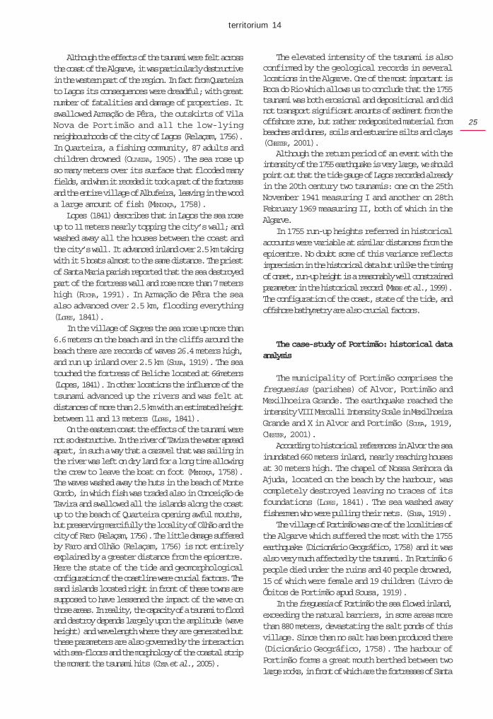
In Portugal the Algarve is one of the regions mostsusceptible to the occurrence of earthquakes. The firstknown earthquake to have been felt in the Algarve datesback from 63 B.C. (OLIVEIRA, 1986), but over the centuriesother events more or less intense have occurred in thatarea (Table 1).
In the 18th century three earthquakes hit the Algarvecausing great destruction. The 1719 earthquake hadits epicentre off the coast of Portimão and reached anestimated magnitude of 7. The 1722 earthquake, witha probable epicentre off the city of Tavira caused greatdamage in the villages of Portimão, Albufeira, Louléand in the cities of Faro and Tavira causing manydeaths and the ruin of churches, convents, wall towers,and uncountable houses, which were left completelydestroyed and uninhabitable (Anno Histórico, TomoIII. fl.546, apud Sousa, 1915).
The 1755 earthquake was even more destructivethan the previous ones, being considered the greatestearthquake of the entire Christian era to have occurredin the Algarve (COSTA et al. 2005). This earthquake
1The questions formulated are the following: 5th Did you notice what happenedto the sea, to fountains and to rivers ?; 6th Did the sea rise or fall first, and howmany “meters”.
2The formulation of question 26 of part I is: If the parish suffered damages causedby the 1755 earthquake, what where they and if they have been repaired? Thequestion 27 of part I of the survey suggests that it should be mentioned everythingimportant not contemplated in this questionnaire (27th And everything elseworthy of memory, not contemplated in this questionnaire.). This question wasused by some priests to refer the tsunami as the priest of Budens (Vila do Bispo) did.
RISCOS - Associação Portuguesa de Riscos, Prevenção e Segurança
24
caused a high death toll. The probable number of morethan 1,000 deceased in all of the Algarve to anestimated population of 80,000 inhabitants clearlyreveals the violence of the earthquake and subsequenttsunami which occurred in this region (COSTA et al,2005). Nevertheless, in some local communities theproportion of deceased was much higher, for instancein Albufeira and Boliqueime, affecting, respectively,10% and 7% of the inhabitants (SOUSA, 1919).
In the latter the majority of the deaths resulted fromthe earthquake, unlike Albufeira where the majority ofthe population died as a consequence of the tsunami.Here, few were the houses that were left standing andthose which resisted were uninhabitable; the seaflooded the land by the outskirts of the village andwashed out the Bairro de Santa Ana, which had sevenstreets, and many other houses without sign of the waterflux and reflux or of the houses location (DicionárioGeográfico, 1758).
In other areas the death toll was not as high but thedestruction was nonetheless enormous. For examplein Vila do Bispo, although only 13 people died(Relaçam, 1755) the village was devastated by the1755 earthquake, since all houses, except for one, werein ruins. The homeless population had to live outdoorsin cold weather deprived of the supplies they had stored,lost under the ruins of the same earthquake (DicionárioGeográfico, 1758). Also all the houses of the village
of Aljezur were in ruins, the taller ones completelydestroyed, as were the castle and the main church(LOPES, 1841).
The city of Lagos was another of the most affected.In the parish of São Sebastião all the houses of the citywere in ruins and in the entire parish only a few one-storey houses were left standing. In this parish 95people perished, some under the ruins, others taken bythe sea. Furthermore in the parish of Santa Maria morethan 100 people died, not to mention the people whowere spending the day away from the city, which weremany, given that this was a holiday (DicionárioGeográfico, 1758).
After 1755 other earthquakes have been felt in thisregion, but luckily with much lower magnitude. A recentearthquake that hit the Algarve in the morning of 12thof February 2007 measuring 5.8 on the Richter scalealerted to the risk that the occurrence of earthquakesrepresents to this region and reminded the importanceof disaster preparedness.
The 1755 tsunami in the Algarve
Some minutes after the earthquake3, the coast ofthe Algarve was swallowed by a tsunami, which causeda great number of deaths and vast destruction. Alongthe coast several fishermen were fishing, despite theholiness of the day; but those unfortunate fishermenwere all killed by the powerful waves (CASTRO, 1786).
The 1755 tsunami was not an unprecedented event.In fact, there are references to tsunamis caused by otherearthquakes which hit the Algarve. A few years earlier,in December 27th, 1722, there was also a tsunamialthough its effects were only felt locally (SOUSA,1915).The historical documents testify to someperplexity and lack of knowledge in people’s reactionto the 1755 tsunami which contributed to a greaternumber of deaths in the coastal communities, as ithappened for instance with the great majority of theinhabitants of the village of Albufeira, located on thetop of a rock, who went down to the beach to findshelter believing the area to be safe. The water hit thebeach and swallowed them all (CASTRO, 1786).
But the intensity of 1755 tsunami was enormous.The sea receded in parts more than 36 meters, exposingthe beaches; and hitting land with such impetus, ran upinland over 5km, topping the highest rocks; it thenreceded again and hitting land for three times in amatter of minutes, dragging in the flux and refluxenormous masses of cliffs and buildings; and devastatingalmost all the coastal populations (LOPES, 1841).
Table 1 – The greatest earthquakes in Algarve.
Source: MARTINS & MENDES VÍCTOR, 2001.a We should point out that the estimated magnitude and epicentre localisationrecorded in the catalogues should be considered as merely indicative (Oliveira,1986, p.133).b The earthquake epicentre is known to have been offshore but the exact locationremains a controversial and debated issue. The plate tectonics of the region arecomplex, and there are several proposals of tectonic sources for the 1755earthquake (Johnston, 1996; Zitelline et al., 2001; Costa et al., 2005; Mirandaet al., 2005; Gutscher, 2004, 2005).
3According to Lopes (1841) the tsunami occurred 6 to 7 minutes after theearthquake. Baptista et al (1998) presents an estimated time of 7 to 16 minutesfor the Cabo de São Vicente.
territorium 14
25
Although the effects of the tsunami were felt acrossthe coast of the Algarve, it was particularly destructivein the western part of the region. In fact from Quarteirato Lagos its consequences were dreadful; with greatnumber of fatalities and damage of properties. Itswallowed Armação de Pêra, the outskirts of VilaNova de Portimão and all the low-lyingneighbourhoods of the city of Lagos (Relaçam, 1756).In Quarteira, a fishing community, 87 adults andchildren drowned (OLIVEIRA, 1905). The sea rose upso many meters over its surface that flooded manyfields, and when it receded it took a part of the fortressand the entire village of Albufeira, leaving in the wooda large amount of fish (MENDONÇA, 1758).
Lopes (1841) describes that in Lagos the sea roseup to 11 meters nearly topping the city’s wall; andwashed away all the houses between the coast andthe city’s wall. It advanced inland over 2.5 km takingwith it 5 boats almost to the same distance. The priestof Santa Maria parish reported that the sea destroyedpart of the fortress wall and rose more than 7 metershigh (ROCHA, 1991). In Armação de Pêra the seaalso advanced over 2.5 km, flooding everything(LOPES, 1841).
In the village of Sagres the sea rose up more than6.6 meters on the beach and in the cliffs around thebeach there are records of waves 26.4 meters high,and run up inland over 2.5 km (SOUSA, 1919). The seatouched the fortress of Beliche located at 66meters(Lopes, 1841). In other locations the influence of thetsunami advanced up the rivers and was felt atdistances of more than 2.5 km with an estimated heightbetween 11 and 13 meters (LOPES, 1841).
On the eastern coast the effects of the tsunami werenot so destructive. In the river of Tavira the water spreadapart, in such a way that a caravel that was sailing inthe river was left on dry land for a long time allowingthe crew to leave the boat on foot (MENDONÇA, 1758).The waves washed away the huts in the beach of MonteGordo, in which fish was traded also in Conceição deTavira and swallowed all the islands along the coastup to the beach of Quarteira opening awful mouths,but preserving mercifully the locality of Olhão and thecity of Faro (Relaçam, 1756). The little damage sufferedby Faro and Olhão (Relaçam, 1756) is not entirelyexplained by a greater distance from the epicentre.Here the state of the tide and geomorphologicalconfiguration of the coastline were crucial factors. Thesand islands located right in front of these towns aresupposed to have lessened the impact of the wave onthose areas. In reality, the capacity of a tsunami to floodand destroy depends largely upon the amplitude (waveheight) and wavelength where they are generated butthese parameters are also governed by the interactionwith sea-floors and the morphology of the coastal stripthe moment the tsunami hits (COSTA et al., 2005).
The elevated intensity of the tsunami is alsoconfirmed by the geological records in severallocations in the Algarve. One of the most important isBoca do Rio which allows us to conclude that the 1755tsunami was both erosional and depositional and didnot transport significant amounts of sediment from theoffshore zone, but rather redeposited material frombeaches and dunes, soils and estuarine silts and clays(CHESTER, 2001).
Although the return period of an event with theintensity of the 1755 earthquake is very large, we shouldpoint out that the tide gauge of Lagos recorded alreadyin the 20th century two tsunamis: one on the 25thNovember 1941 measuring I and another on 28thFebruary 1969 measuring II, both of which in theAlgarve.
In 1755 run-up heights referred in historicalaccounts were variable at similar distances from theepicentre. No doubt some of this variance reflectsimprecision in the historical data but unlike the timingof onset, run-up height is a reasonably well constrainedparameter in the historical record (MENDES et al., 1999).The configuration of the coast, state of the tide, andoffshore bathymetry are also crucial factors.
The case-study of Portimão: historical dataanalysis
The municipality of Portimão comprises thefreguesias (parishes) of Alvor, Portimão andMexilhoeira Grande. The earthquake reached theintensity VIII Mercalli Intensity Scale in MexilhoeiraGrande and X in Alvor and Portimão (SOUSA, 1919,CHESTER, 2001).
According to historical references in Alvor the seainundated 660 meters inland, nearly reaching housesat 30 meters high. The chapel of Nossa Senhora daAjuda, located on the beach by the harbour, wascompletely destroyed leaving no traces of itsfoundations (LOPES, 1841). The sea washed awayfishermen who were pulling their nets. (SOUSA, 1919).
The village of Portimão was one of the localities ofthe Algarve which suffered the most with the 1755earthquake (Dicionário Geográfico, 1758) and it wasalso very much affected by the tsunami. In Portimão 6people died under the ruins and 40 people drowned,15 of which were female and 19 children (Livro deÓbitos de Portimão apud Sousa, 1919).
In the freguesia of Portimão the sea flowed inland,exceeding the natural barriers, in some areas morethan 880 meters, devastating the salt ponds of thisvillage. Since then no salt has been produced there(Dicionário Geográfico, 1758). The harbour ofPortimão forms a great mouth berthed between twolarge rocks, in front of which are the fortresses of Santa
RISCOS - Associação Portuguesa de Riscos, Prevenção e Segurança
26
Catarina and São João. The first of the two was severelydamaged (Dicionário Geográfico, 1758) and the latestwas completely washed out (LOPES, 1841).
Through the village of Portimão flowedsuccessively amazing waves, which advanced over5km up the river. As the waves advanced everythingwas destroyed. Several boats were carried inlandto such great distance that it was not possible tobring them back. Flooding occurred on the outskirtsof the village, destroying all the houses and drowningmany people, which had sought refuge in the riverbanks (CASTRO, 1786).
In the parish of Mexilhoeira the damages werenot as important because the parish has no directcontact with the sea. The damages caused by thetsunami resulted from the advance of the waves upthe River Alvor and other smaller water courses, but
nothing worse mentioning happened (DicionárioGeográfico, 1758).
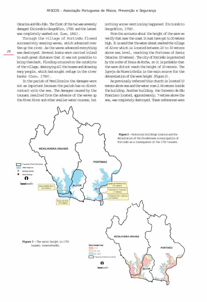
From the accounts about the height of the wave weverify that near the coast it must have got to 20 metershigh. It is said that the water almost reached the villageof Alvor which is located between 20 to 30 metersabove sea level, reaching the Fortress of SantaCatarina (20 meters). The city of Portimão is protectedby the rocks of Praia da Rocha, so it is probable thatthe wave did not reach the height of 20 meters. TheIgreja da Misericórdia is the main source for thedetermination of the wave height (Figure 2).
As previously referred this church is located 10meters above sea and the water rose 2.64 meters insidethe building. Another building, the Convento de SãoFrancisco located, approximately, 7 metres above thesea, was completely destroyed. These references were
Figure 3 – The water height in 1755tsunami: inverted model.
Figure 2 - Historical buildings location and thedelimitation of the flooded area in municipality ofPortimão as a consequence of the 1755 tsunami.
territorium 14
27
integrated in the map over the Digital Terrain Model(DTM). According to historical sources the height of12 meters was considered a reliable height for most ofthe wave but it is possible that in small areas the wavecould have reached higher heights as it happened inFortress of Santa Catarina located on a cliff edge.
Based in the DTM, the lands with altitude below12 meters and near the coast had been identified,eliminating isolated areas surrounded by landshigher than 12 meters, producing a new DTM of thewave height (inverted) and in a polygon the floodedarea (Figure 3).
The impacts of the 1755 tsunami nowadays
The flooded area should have amounted to 23.75Km2, 13% of the total surface of the municipality. Anextension explained by the fact that this is a sandycoast with a reduced number of cliffs and by theexistence of two rivers, natural boundaries of themunicipality, serving as hallways allowing the advanceof the waves.
Since 1755, two key factors have increased thevulnerability in Portimão municipality. Seasidesettlement is no longer solely based on livelihood buton urbanization and tourism associated with theattraction of enjoying living and holidaying literally infront of the sea.
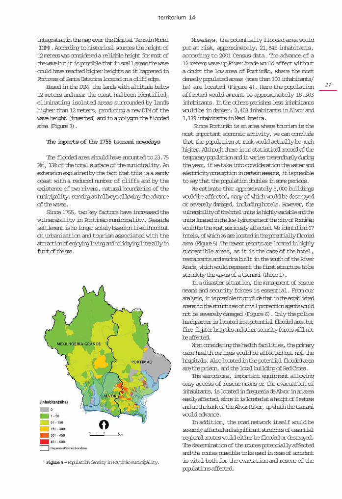
Nowadays, the potentially flooded area wouldput at risk, approximately, 21,845 inhabitants,according to 2001 Census data. The advance of a12 meters wave up River Arade would affect withouta doubt the low area of Portimão, where the mostdensely populated areas (more than 300 inhabitants/ha) are located (Figure 4). Here the populationaffected would amount to approximately 18,303inhabitants. In the others parishes less inhabitantswould be in danger: 2,403 inhabitants in Alvor and1,139 inhabitants in Mexilhoeira.
Since Portimão is an area where tourism is themost important economic activity, we can concludethat the population at risk would actually be muchhigher. Although there is no statistical record of thetemporary population and it varies tremendously duringthe year, if we take into consideration the water andelectricity consumption in certain seasons, it is possibleto say that the population doubles in some periods.
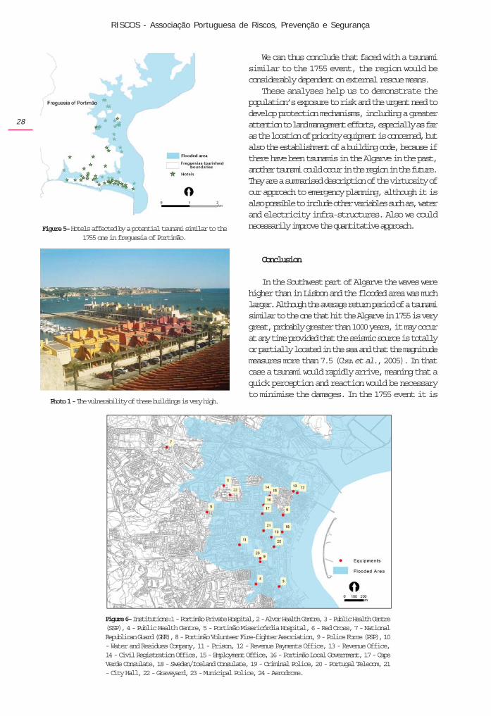
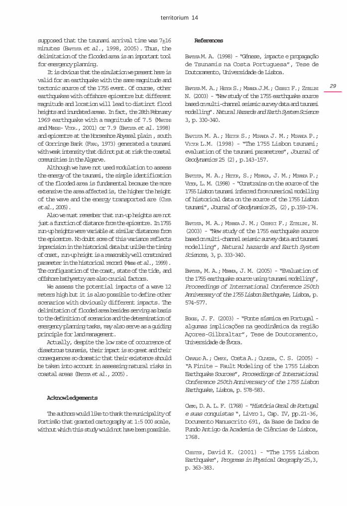
We estimate that approximately 5,000 buildingswould be affected, many of which would be destroyedor severely damaged, including hotels. However, thevulnerability of the hotel units is highly variable and theunits located in the low-lying parts of the city of Portimãowould be the most seriously affected. We identified 67hotels, of which 26 are located in the potentially floodedarea (Figure 5).The newest resorts are located in highlysusceptible areas, as it is the case of the hotel,restaurants and marina built in the mouth of the RiverArade, which would represent the first structure to bestruck by the waves of a tsunami (Photo 1).
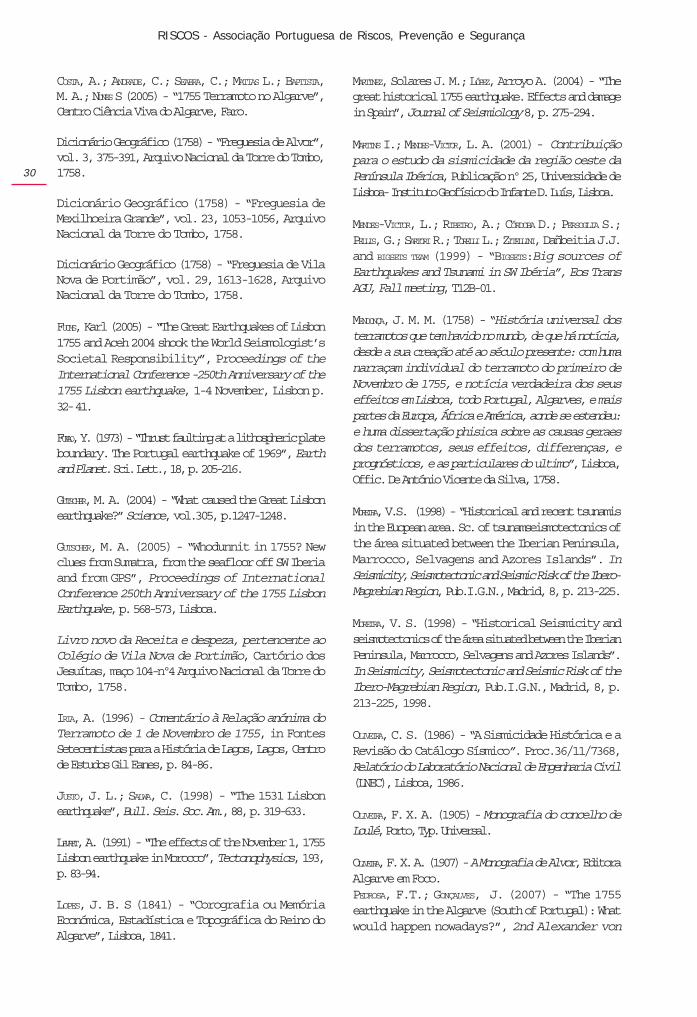
In a disaster situation, the management of rescuemeans and security forces is essential. From ouranalysis, it is possible to conclude that in the establishedscenario the structures of civil protection agents wouldnot be severely damaged (Figure 6). Only the policeheadquarter is located in a potential flooded area butfire-fighter brigades and other security forces will notbe affected.
When considering the health facilities, the primarycare health centres would be affected but not thehospitals. Also located in the potential flooded areaare the prison, and the local building of Red Cross.
The aerodrome, important equipment allowingeasy access of rescue means or the evacuation ofinhabitants, is located in freguesia de Alvor in an areaeasily affected, since it is located at a height of 5 metresand on the bank of the Alvor River, up which the tsunamiwould advance.
In addition, the road network itself would beseverely affected and significant stretches of essentialregional routes would either be flooded or destroyed.The determination of the routes potencially affectedand the routes possible to be used in case of accidentis vital both for the evacuation and rescue of thepopulations affected.
Figure 4 – Population density in Portimão municipality.
RISCOS - Associação Portuguesa de Riscos, Prevenção e Segurança
28
We can thus conclude that faced with a tsunamisimilar to the 1755 event, the region would beconsiderably dependent on external rescue means.
These analyses help us to demonstrate thepopulation’s exposure to risk and the urgent need todevelop protection mechanisms, including a greaterattention to land management efforts, especially as faras the location of priority equipment is concerned, butalso the establishment of a building code, because ifthere have been tsunamis in the Algarve in the past,another tsunami could occur in the region in the future.They are a summarised description of the virtuosity ofour approach to emergency planning, although it isalso possible to include other variables such as, waterand electricity infra-structures. Also we couldnecessarily improve the quantitative approach.
Conclusion
In the Southwest part of Algarve the waves werehigher than in Lisbon and the flooded area was muchlarger. Although the average return period of a tsunamisimilar to the one that hit the Algarve in 1755 is verygreat, probably greater than 1000 years, it may occurat any time provided that the seismic source is totallyor partially located in the sea and that the magnitudemeasures more than 7.5 (COSTA et al., 2005). In thatcase a tsunami would rapidly arrive, meaning that aquick perception and reaction would be necessaryto minimise the damages. In the 1755 event it is
Figure 6– Institutions:1 - Portimão Private Hospital, 2 - Alvor Health Centre, 3 - Public Health Centre(SSP), 4 - Public Health Centre, 5 - Portimão Misericórdia Hospital, 6 - Red Cross, 7 - NationalRepublican Guard (GNR), 8 - Portimão Volunteer Fire-fighter Association, 9 - Police Force (PSP), 10- Water and Residues Company, 11 - Prison, 12 - Revenue Payments Office, 13 - Revenue Office,14 - Civil Registration Office, 15 - Employment Office, 16 - Portimão Local Government, 17 - CapeVerde Consulate, 18 - Sweden/Iceland Consulate, 19 - Criminal Police, 20 - Portugal Telecom, 21- City Hall, 22 - Graveyard, 23 - Municipal Police, 24 - Aerodrome.
Figure 5– Hotels affected by a potential tsunami similar to the1755 one in freguesia of Portimão.
Photo 1 - The vulnerability of these buildings is very high.
territorium 14
29
supposed that the tsunami arrival time was 7±16minutes (BAPTISTA et al., 1998, 2005). Thus, thedelimitation of the flooded area is an important toolfor emergency planning.
It is obvious that the simulation we present here isvalid for an earthquake with the same magnitude andtectonic source of the 1755 event. Of course, otherearthquakes with offshore epicentre but differentmagnitude and location will lead to distinct floodheights and inundated areas. In fact, the 28th February1969 earthquake with a magnitude of 7.5 (MARTINSand MENDES- VITOR., 2001) or 7.9 (BAPTISTA et al. 1998)and epicentre at the Horseshoe Abyssal plain , southof Gorringe Bank (FUKAO, 1973) generated a tsunamiwith weak intensity that did not put at risk the coastalcommunities in the Algarve.
Although we have not used modulation to assessthe energy of the tsunami, the simple identificationof the flooded area is fundamental because the moreextensive the area affected is, the higher the heightof the wave and the energy transported are (COSTAet al., 2005).
Also we must remember that run-up heights are notjust a function of distance from the epicentre. In 1755run-up heights were variable at similar distances fromthe epicentre. No doubt some of this variance reflectsimprecision in the historical data but unlike the timingof onset, run-up height is a reasonably well constrainedparameter in the historical record (MENDES et al., 1999).The configuration of the coast, state of the tide, andoffshore bathymetry are also crucial factors.
We assess the potential impacts of a wave 12meters high but it is also possible to define otherscenarios with obviously different impacts. Thedelimitation of flooded area besides serving as basisto the definition of scenarios and the determination ofemergency planning tasks, may also serve as a guidingprinciple for land management.
Actually, despite the low rate of occurrence ofdisastrous tsunamis, their impact is so great and theirconsequences so dramatic that their existence shouldbe taken into account in assessing natural risks incoastal areas (BAPTISTA et al., 2005).
Acknowledgements
The authors would like to thank the municipality ofPortimão that granted cartography at 1:5 000 scale,without which this study would not have been possible.
References
BAPTISTA M. A. (1998) - “Génese, impacte e propagaçãode Tsunamis na Costa Portuguesa”, Tese deDoutoramento, Universidade de Lisboa.
BAPTISTA M. A.; HEITOR S.; MIRANDA J.M.; CHIERICI F.; ZITELLININ. (2003) - “New study of the 1755 earthquake sourcebased on multi-channel seismic survey data and tsunamimodelling”. Natural Hazards and Earth System Science3, p. 330-340.
BAPTISTA M. A.; HEITOR S.; MIRANDA J. M.; MIRANDA P.;VICTOR L.M. (1998) - “The 1755 Lisbon tsunami;evaluation of the tsunami parametres”, Journal ofGeodynamics 25 (2), p.143-157.
BAPTISTA, M. A.; HEITOR, S.; MIRANDA, J. M.; MIRANDA P.;VICTOR, L. M. (1998) - “Constrains on the source of the1755 Lisbon tsunami inferred from numerical modellingof historical data on the source of the 1755 Lisbontsunami”, Journal of Geodynamics 25, (2), p.159-174.
BAPTISTA, M. A.; MIRANDA J. M.; CHIERICI F.; ZITELLINI, N.(2003) - “New study of the 1755 earthquake sourcebased on multi-channel seismic survey data and tsunamimodelling”, Natural hazards and Earth SystemSciences, 3, p. 333-340.
BAPTISTA, M. A.; MIRANDA, J. M. (2005) - “Evaluation ofthe 1755 earthquake source using tsunami modelling”,Proceedings of International Conference 250thAnniversary of the 1755 Lisbon Earthquake, Lisboa, p.574-577.
BORGES, J. F. (2003) - “Fonte sísmica em Portugal -algumas implicações na geodinâmica da regiãoAçores-Gilbraltar”, Tese de Doutoramento,Universidade de Évora.
CARVALHO A.; CAMPOS, Costa A.; OLIVEIRA, C. S. (2005) -“A Finite – Fault Modeling of the 1755 LisbonEarthquake Sources”, Proceedings of InternationalConference 250th Anniversary of the 1755 LisbonEarthquake, Lisboa, p. 578-583.
CASTRO, D. A. L. F. (1768) - “História Geral de Portugale suas conquistas “, Livro 1, Cap. IV, pp.21-36,Documento Manuscrito 691, da Base de Dados deFundo Antigo da Academia de Ciências de Lisboa,1768.
CHESTER, David K. (2001) - “The 1755 LisbonEarthquake”, Progress in Physical Geography 25,3,p. 363-383.
RISCOS - Associação Portuguesa de Riscos, Prevenção e Segurança
30
COSTA, A.; ANDRADE, C.; SEABRA, C.; MATIAS L.; BAPTISTA,M. A.; NUNES S (2005) - “1755 Terramoto no Algarve”,Centro Ciência Viva do Algarve, Faro.
Dicionário Geográfico (1758) - “Freguesia de Alvor”,vol. 3, 375-391, Arquivo Nacional da Torre do Tombo,1758.
Dicionário Geográfico (1758) - “Freguesia deMexilhoeira Grande”, vol. 23, 1053-1056, ArquivoNacional da Torre do Tombo, 1758.
Dicionário Geográfico (1758) - “Freguesia de VilaNova de Portimão”, vol. 29, 1613-1628, ArquivoNacional da Torre do Tombo, 1758.
FUCHS, Karl (2005) - “The Great Earthquakes of Lisbon1755 and Aceh 2004 shook the World Seismologist’sSocietal Responsibility”, Proceedings of theInternational Conference -250th Anniversary of the1755 Lisbon earthquake, 1-4 November, Lisbon p.32- 41.
FUKAO, Y. (1973) - “Thrust faulting at a lithospheric plateboundary. The Portugal earthquake of 1969”, Earthand Planet. Sci. Lett., 18, p. 205-216.
GUTSCHER, M. A. (2004) - “What caused the Great Lisbonearthquake?” Science, vol.305, p.1247-1248.
GUTSCHER, M. A. (2005) - “Whodunnit in 1755? Newclues from Sumatra, from the seafloor off SW Iberiaand from GPS”, Proceedings of InternationalConference 250th Anniversary of the 1755 LisbonEarthquake, p. 568-573, Lisboa.
Livro novo da Receita e despeza, pertencente aoColégio de Vila Nova de Portimão, Cartório dosJesuítas, maço 104-nº4 Arquivo Nacional da Torre doTombo, 1758.
IRIA, A. (1996) - Comentário à Relação anónima doTerramoto de 1 de Novembro de 1755, in FontesSetecentistas para a História de Lagos, Lagos, Centrode Estudos Gil Eanes, p. 84-86.
JUSTO, J. L.; SALWA, C. (1998) - “The 1531 Lisbonearthquake”, Bull. Seis. Soc. Am., 88, p. 319-633.
LEVRET, A. (1991) - “The effects of the November 1, 1755Lisbon earthquake in Morocco”, Tectonophysics, 193,p. 83-94.
LOPES, J. B. S (1841) - “Corografia ou MemóriaEconómica, Estadística e Topográfica do Reino doAlgarve”, Lisboa, 1841.
MARTINEZ, Solares J. M.; LÓPEZ, Arroyo A. (2004) - “Thegreat historical 1755 earthquake. Effects and damagein Spain”, Journal of Seismiology 8, p. 275-294.
MARTINS I.; MENDES-VICTOR, L. A. (2001) - Contribuiçãopara o estudo da sismicidade da região oeste daPenínsula Ibérica, Publicação nº 25, Universidade deLisboa- Instituto Geofísico do Infante D. Luís, Lisboa.
MENDES-VICTOR, L.; RIBEIRO, A.; CÓRDOBA D.; PERSOGLIA S.;PELLIS, G.; SARTORI R.; TORELLI L.; ZITELLINI, Dañbeitia J.J.and BIGSETS TEAM (1999) - “BIGSETS:Big sources ofEarthquakes and Tsunami in SW Ibéria”, Eos TransAGU, Fall meeting, T12B-01.
MENDONÇA, J. M. M. (1758) - “História universal dosterramotos que tem havido no mundo, de que há notícia,desde a sua creação até ao século presente: com humanarraçam individual do terramoto do primeiro deNovembro de 1755, e notícia verdadeira dos seuseffeitos em Lisboa, todo Portugal, Algarves, e maispartes da Europa, África e América, aonde se estendeu:e huma dissertação phisica sobre as causas geraesdos terramotos, seus effeitos, differenças, eprognósticos, e as particulares do ultimo”, Lisboa,Offic. De António Vicente da Silva, 1758.
MOREIRA, V.S. (1998) - “Historical and recent tsunamisin the Euopean area. Sc. of tsunamseismotectonics ofthe área situated between the Iberian Peninsula,Marrocco, Selvagens and Azores Islands”. InSeismicity, Seismotectonic and Seismic Risk of the Ibero-Magrebian Region, Pub.I.G.N., Madrid, 8, p. 213-225.
MOREIRA, V. S. (1998) - “Historical Seismicity andseismotectonics of the área situated between the IberianPeninsula, Marrocco, Selvagens and Azores Islands”.In Seismicity, Seismotectonic and Seismic Risk of theIbero-Magrebian Region, Pub.I.G.N., Madrid, 8, p.213-225, 1998.
OLIVEIRA, C. S. (1986) - “A Sismicidade Histórica e aRevisão do Catálogo Sísmico”. Proc.36/11/7368,Relatório do Laboratório Nacional de Engenharia Civil(LNEC), Lisboa, 1986.
OLIVEIRA, F. X. A. (1905) - Monografia do concelho deLoulé, Porto, Typ. Universal.
OLIVEIRA, F. X. A. (1907) - A Monografia de Alvor, EditoraAlgarve em Foco.PEDROSA, F.T.; GONÇALVES, J. (2007) - “The 1755earthquake in the Algarve (South of Portugal): Whatwould happen nowadays?”, 2nd Alexander von
territorium 14
31
Humboldt International Conference on The Role ofGeophysics in Natural Disaster Prevention, Lima, Peru.
ROCHA, M. J. P. (1991) - Monografia de Lagos, reediçãode um original de 1909, Alvor, Editora Algarve emFoco.
Relaçãm do terramoto do primeiro de Novembro doanno de 1755 com os efeitos, que particularmentecauzou neste Reino do Algarve, Faro, Biblioteca daUniversidade de Coimbra, Manuscrito do Códice 537,fls159-163, 1756.
SANCHES, A.N.R. (1996) - Tratado da Conservação daSaúde dos Povos: Obra útil, e igualmente necessáriaa os Magistrados; Capitaens Generais, Capitaens Mar,e Guerra, Prelados, Abbadessas, Médicos, e Pays deFamílias:Comu hum appendix, Consideraçoins sobreos Terremotos, com a noticia dos mais consideráveis,de que faz mençaô a História, e dos últimos que sesintiraô na Europa desde o 1 de Novembro 1755,Paris, publicado in SANCHES, A. N. R. (1966) Obras,Vol. II, Apontamentos para estabelecer-se um tribunale colégio de medicina- Carta a Joaquim Pedro de Abreu– Tratado da Conservação da Saúde, Coimbra,Universidade de Coimbra, p.149-391, 1761.
SOUSA, F. L. P. (1915) - “O megasismo do 1º deNovembro de 1755 3m Portugal- Distrito de Faro,Acompanhado de um estudo demográfico e sobrerochas de construção”, extracto da Revista de ObrasPúblicas e Minas, Lisboa, Tipografia do Comércio.
SOUSA, F. L. P. (1919) - O terramoto do 1º de Novembrode 1755 em Portugal e Um Estudo Demográfico,Serviços Geológicos, Lisboa.
VIEIRA, J. G. 81911) - Memória Monographica de VillaNova de Portimão, Typographia Universal.
ZITELLINI, N. et al. (2001) - “Source of 1755 Lisbonearthquake, tsunami investigated”, EOS, nº26, p.285-291.

RISCOS - Associação Portuguesa de Riscos, Prevenção e Segurança
32
territorium 14
33
QUATERNARY EVOLUTION OF THE SERRA DO MARÃO AND ITS CONSEQUENCESIN THE PRESENT DYNAMICS
António de Sousa Pedrosa, Bernardo Serpa Marques,Bruno Martins, José Henrique Sousa
Faculdade de Letras, Universidade do [email protected]
RESUMO
Situada no Norte de Portugal, a Serra do Marão faz parte de um conjunto orográfico que separa a áreamontanhosa de Entre Douro e Minho da área planáltica de Trás-os-Montes. As características do tempo nasépocas mais frias do Quaternário foram muito importantes no que respeita aos processos morfogenéticos, queactuaram sobre as suas vertentes, criando depósitos que então as regularizaram e que hoje condicionam adinâmica actual.
Palavras chave: Quaternário, depósitos periglaciares, dinâmica de vertentes, ravinas, deslizamentos.
ABSTRACT
Localised in the north of Portugal, Serra do Marão is part of a mountainous range that separates the mountainsof Entre Douro e Minho from the plateaux of Trás-os-Montes. Weather characteristics of Quaternary coldest timeswere very important in terms of morphogenetic processes, which acted on its slopes, creating deposits that,nowadays, are conditioning the present dynamics.
Key words: Quaternary, periglacial deposits, slope dynamics, gullies, landslides.
RÉSUMÉ
Située dans le nord du Portugal, la Serra do Marão fait partie de l'ensemble orographique qui sépare leshauteurs de l'Entre Douro et Minho des plateaux du Trás-os-Montes. Les caractéristiques des temps froids duQuaternaire ont été très importantes en ce qui concerne les processus morphogénétiques existants sur les versants,aujourd'hui conditionnant la dynamique actuelle.
Mots clé: Quaternaire, dépôts périglaciaires, dynamique de versants, ravins, glissements.
pp. 33-43
RISCOS - Associação Portuguesa de Riscos, Prevenção e Segurança
34
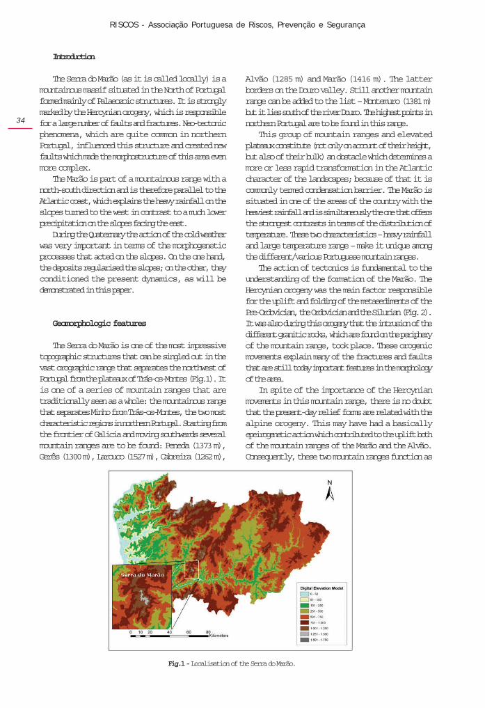
Introduction
The Serra do Marão (as it is called locally) is amountainous massif situated in the North of Portugalformed mainly of Palaeozoic structures. It is stronglymarked by the Hercynian orogeny, which is responsiblefor a large number of faults and fractures. Neo-tectonicphenomena, which are quite common in northernPortugal, influenced this structure and created newfaults which made the morphostructure of this area evenmore complex.
The Marão is part of a mountainous range with anorth-south direction and is therefore parallel to theAtlantic coast, which explains the heavy rainfall on theslopes turned to the west in contrast to a much lowerprecipitation on the slopes facing the east.
During the Quaternary the action of the cold weatherwas very important in terms of the morphogeneticprocesses that acted on the slopes. On the one hand,the deposits regularised the slopes; on the other, theyconditioned the present dynamics, as will bedemonstrated in this paper.
Geomorphologic features
The Serra do Marão is one of the most impressivetopographic structures that can be singled out in thevast orographic range that separates the northwest ofPortugal from the plateaux of Trás-os-Montes (Fig.1). Itis one of a series of mountain ranges that aretraditionally seen as a whole: the mountainous rangethat separates Minho from Trás-os-Montes, the two mostcharacteristic regions in northern Portugal. Starting fromthe frontier of Galicia and moving southwards severalmountain ranges are to be found: Peneda (1373 m),Gerês (1300 m), Larouco (1527 m), Cabreira (1262 m),
Alvão (1285 m) and Marão (1416 m). The latterborders on the Douro valley. Still another mountainrange can be added to the list – Montemuro (1381 m)but it lies south of the river Douro. The highest points innorthern Portugal are to be found in this range.
This group of mountain ranges and elevatedplateaux constitute (not only on account of their height,but also of their bulk) an obstacle which determines amore or less rapid transformation in the Atlanticcharacter of the landscapes; because of that it iscommonly termed condensation barrier. The Marão issituated in one of the areas of the country with theheaviest rainfall and is simultaneously the one that offersthe strongest contrasts in terms of the distribution oftemperature. These two characteristics – heavy rainfalland large temperature range – make it unique amongthe different/various Portuguese mountain ranges.
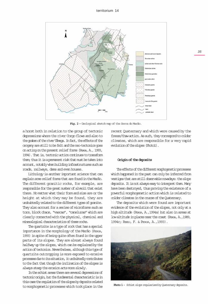
The action of tectonics is fundamental to theunderstanding of the formation of the Marão. TheHercynian orogeny was the main factor responsiblefor the uplift and folding of the metasediments of thePre-Ordovician, the Ordovician and the Silurian (Fig. 2).It was also during this orogeny that the intrusion of thedifferent granitic rocks, which are found on the peripheryof the mountain range, took place. These orogenicmovements explain many of the fractures and faultsthat are still today important features in the morphologyof the area.
In spite of the importance of the Hercynianmovements in this mountain range, there is no doubtthat the present-day relief forms are related with thealpine orogeny. This may have had a basicallyepeirogenetic action which contributed to the uplift bothof the mountain ranges of the Marão and the Alvão.Consequently, these two mountain ranges function as
Fig.1 - Localisation of the Serra do Marão.
territorium 14
35
a horst both in relation to the group of tectonicdepressions where the river Corgo flows and also tothe graben of the river Tâmega. In fact, the effects of theorogeny are still to be felt and the neo-tectonics goeson acting on the present relief forms (PEDROSA, A., 1993,1994). That is, tectonic action continues to transformthem; thus it is a permanent risk that must be taken intoaccount, notably when building infrastructures such asroads, railways, dams and even houses.
Lithology is another important science that canexplain some relief forms that are found in the Marão.The different granitic rocks, for example, areresponsible for the great number of alveoli that existthere. No matter what their form and size are or theheight at which they may be found, they areundoubtedly related to the different types of granite.They also account for a series of microforms such astors, block chaos, “vascas”, “caneluras” which areclearly connected with the physical, chemical andmineralogical characteristics of these rocks.
The quartzite is a type of rock that has a specialimportance in the morphology of the Marão (PEDROSA,1993) in spite of being quite often found in the upperparts of its slopes. They are almost always foundhalfway up the slopes, which can be explained by theaction of tectonics. Nevertheless, although this type ofquartzite outcropping is more exposed to erosiveprocesses due to its situation, it undoubtedly contributesto the fact that though the inclination of the slopes isalways steep the erosion acts more slowly.
In the schist areas there are several depressions oftectonic origin, but the fundamental characteristic is inthis case the regulation of the slopes by deposits relatedto morphogenetic processes which took place in the
recent Quaternary and which were caused by thefreeze/thaw action. As such, they correspond to colderclimates, which are responsible for a very rapidevolution of the slopes (Photo1).
Origin of the deposits
The effects of the different morphogenetic processeswhich happened in the past can only be inferred fromvestiges that are still observable nowadays: the slopedeposits. It is not always easy to interpret them. Manyhave been destroyed, thus proving the existence of apowerful morphogenetic action which is related tocolder climates in the course of the Quaternary.
The deposits which were found are importantevidence of the evolution of the slopes, not only at ahigh altitude (PEDROSA, A.,1994a) but also in areas atlow altitude in places near the coast (PEDROSA, A.,1989,1994c; REBELO, F. & PEDROSA, A.,1993).
Fig. 2 – Geological sketch map of the Serra do Marão.
Photo 1 - Schist slope regularised by Quaternary deposits.
RISCOS - Associação Portuguesa de Riscos, Prevenção e Segurança
36
The climate must then have been much moreunstable than it is now with temperatures that madegelifraction in situ possible, above all in higher placeswhere vegetation was scarce or non-existent.
The material must have been made transportedalong the slopes by gelifluction associated with a cold,dry climate (DAVEAU, S., 1973; REBELO, F. 1986; CORDEIRO,A. R., 1986a; PEDROSA, A., 1993, 1994a); it is possibleto observe the existence of coiffes (VALADAS, B., 1984).Nevertheless, the above mentioned movement must nothave been carried out only by the action of ice but alsoby means of more or less generalised solifluctions oreven by debris flows and sheet floods. The existence ofpalaeogullies may lead to the conclusion that therewere larger quantities of water, at least during part ofthe year; this would make possible the formation ofgullies in the materials accumulated at the foot of theslopes by other morphogenetic processes.
Thus, the accumulation of materials along theslopes would have been necessary for the formation ofsuch palaeogullies but the morphogenetic processescould have been different. Absolutely necessary fortheir formation was, however, the alternation of drier,colder periods with others which were damper andhypothetically less cold (PEDROSA, A.,1993).
The palaeosols found seem to indicate climaticfluctuations during which the existence of colderclimates, hypothetically drier, contrasted with periodsof higher biostasis which might mean that there werehigher quantities of rainfall and/or milder temperatures.
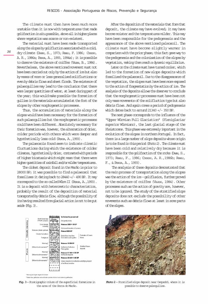
The oldest deposit found in the Marão is prior to28000 BP; it was possible to find a palaeosol thatfossilises it dating back to 28440 +/- 490 BP. It maycorrespond to the so called Würm II (PEDROSA, A.,1993).It is a deposit with heterometric characteristics,probably the result of the deposition of materialtransported by debris flow, although the possibility ofits having resulted from glacial action is not to be putaside (Fig. 3).
After the deposition of the materials that form thatdeposit, the climate may have evolved; it may havebecome moister and the temperatures milder. This mayhave been responsible for the pedogenesis and theappearance of the above mentioned paleosoil. Theclimate must have become slightly warmer incomparison with the prior phase; this fact gave way tothe pedogenesis and the colonisation of the slopes byvegetation, making them reach a dynamic equilibrium.
Later on the climate must have turned cooler, whichled to the formation of new slope deposits whichfossilised the palaeosoil. Due to the disappearance ofthe vegetation, the slopes must have been more exposedto the action of fragmentation by the action of ice. Theanalysis of the deposits allows the observer to concludethat the morphogenetic processes must have been notonly mass movements of the solifluction type but alsodebris flows. And again comes a period of pedogenesiswhich dates back to around 21340 +/- 350 BP.
The next phase corresponds to the influence of the“Upper Würmian Full Glaciation” (Pleniglaciarsuperior Würmiano), the last glacial stage of thePleistocene. This phase was extremely important in theevolution of the slopes in northern Portugal. In fact,there is a large number of slope deposits whose originis to be found in this period (Photo 2). The climate musthave been cold and relatively dry because it isresponsible for the gelifraction of the rocks (DAVEAU, S.,1973; REBELO, F., 1986; CORDEIRO, A. R.,1986b; REBELO,F., & PEDROSA, A., 1993).
The analysis of these deposits demonstrated thatthe main process of transportation along the slopeswas the action of the ice – gelifluxion, further provedby the existence of coiffes (VALADAS, 1984). Otherprocesses such as the action of gravity are, however,not to be ignored. The study of the stratified slopedeposits does not exclude the possibility of othermovements such as debris flows at least in some partsof the slopes.
Fig. 3 – Stratigraphic column of the superficial formations inthe area of the Serra do Marão.
Photo 2 – Stratified slope deposit near Campanhó, where it ispossible to observe paleogullies.
territorium 14
37
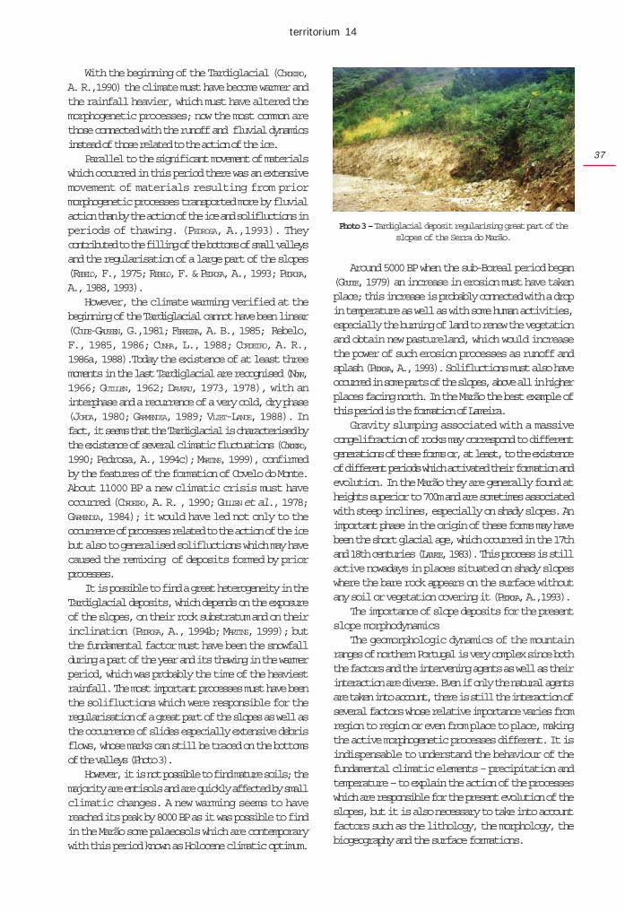
With the beginning of the Tardiglacial (CORDEIRO,A. R.,1990) the climate must have become warmer andthe rainfall heavier, which must have altered themorphogenetic processes; now the most common arethose connected with the runoff and fluvial dynamicsinstead of those related to the action of the ice.
Parallel to the significant movement of materialswhich occurred in this period there was an extensivemovement of materials resulting from priormorphogenetic processes transported more by fluvialaction than by the action of the ice and solifluctions inperiods of thawing. (PEDROSA, A.,1993). Theycontributed to the filling of the bottoms of small valleysand the regularisation of a large part of the slopes(REBELO, F., 1975; REBELO, F. & PEDROSA, A., 1993; PEDROSA,A., 1988, 1993).
However, the climate warming verified at thebeginning of the Tardiglacial cannot have been linear(COUDE-GAUSSEN, G.,1981; FERREIRA, A. B., 1985; Rebelo,F., 1985, 1986; CUNHA, L., 1988; CORDEIRO, A. R.,1986a, 1988).Today the existence of at least threemoments in the last Tardiglacial are recognised (NONN,1966; GUILLEN, 1962; DAVEAU, 1973, 1978), with aninterphase and a recurrence of a very cold, dry phase(JORDA, 1980; GARMENDIA, 1989; VLIET-LANOE, 1988). Infact, it seems that the Tardiglacial is characterised bythe existence of several climatic fluctuations (CORDEIRO,1990; Pedrosa, A., 1994c); MARTINS, 1999), confirmedby the features of the formation of Covelo do Monte.About 11000 BP a new climatic crisis must haveoccurred (CORDEIRO, A. R. , 1990; GULLIEN et al., 1978;GARMENDIA, 1984); it would have led not only to theoccurrence of processes related to the action of the icebut also to generalised solifluctions which may havecaused the remixing of deposits formed by priorprocesses.
It is possible to find a great heterogeneity in theTardiglacial deposits, which depends on the exposureof the slopes, on their rock substratum and on theirinclination (PEDROSA, A., 1994b; MARTINS, 1999); butthe fundamental factor must have been the snowfallduring a part of the year and its thawing in the warmerperiod, which was probably the time of the heaviestrainfall. The most important processes must have beenthe solifluctions which were responsible for theregularisation of a great part of the slopes as well asthe occurrence of slides especially extensive debrisflows, whose marks can still be traced on the bottomsof the valleys (Photo 3).
However, it is not possible to find mature soils; themajority are entisols and are quickly affected by smallclimatic changes. A new warming seems to havereached its peak by 8000 BP as it was possible to findin the Marão some palaeosols which are contemporarywith this period known as Holocene climatic optimum.
Around 5000 BP when the sub-Boreal period began(GOUDIE, 1979) an increase in erosion must have takenplace; this increase is probably connected with a dropin temperature as well as with some human activities,especially the burning of land to renew the vegetationand obtain new pastureland, which would increasethe power of such erosion processes as runoff andsplash (PEDROSA, A., 1993). Solifluctions must also haveoccurred in some parts of the slopes, above all in higherplaces facing north. In the Marão the best example ofthis period is the formation of Lameira.
Gravity slumping associated with a massivecongelifraction of rocks may correspond to differentgenerations of these forms or, at least, to the existenceof different periods which activated their formation andevolution. In the Marão they are generally found atheights superior to 700m and are sometimes associatedwith steep inclines, especially on shady slopes. Animportant phase in the origin of these forms may havebeen the short glacial age, which occurred in the 17thand 18th centuries (LADURIE, 1983). This process is stillactive nowadays in places situated on shady slopeswhere the bare rock appears on the surface withoutany soil or vegetation covering it (PEDROSA, A.,1993).
The importance of slope deposits for the presentslope morphodynamics
The geomorphologic dynamics of the mountainranges of northern Portugal is very complex since boththe factors and the intervening agents as well as theirinteraction are diverse. Even if only the natural agentsare taken into account, there is still the interaction ofseveral factors whose relative importance varies fromregion to region or even from place to place, makingthe active morphogenetic processes different. It isindispensable to understand the behaviour of thefundamental climatic elements – precipitation andtemperature – to explain the action of the processeswhich are responsible for the present evolution of theslopes, but it is also necessary to take into accountfactors such as the lithology, the morphology, thebiogeography and the surface formations.
Photo 3 – Tardiglacial deposit regularising great part of theslopes of the Serra do Marão.
RISCOS - Associação Portuguesa de Riscos, Prevenção e Segurança
38
The importance of the formation of gullies
In these areas the formation of gullies is clearlyconditioned by the existence of a slope deposit, whichworks as a regulator because there are no trees orquite often because man has acted on this terrain.
The examples that will now be given show clearlywhat has just been said.
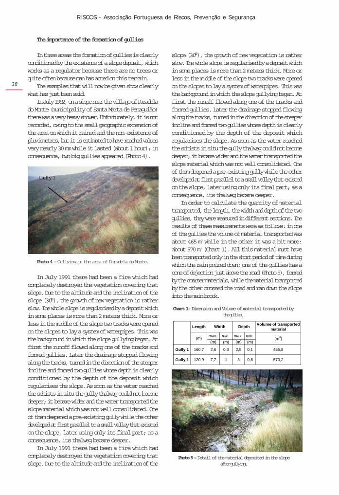
In July 1992, on a slope near the village of Paradelado Monte (municipality of Santa Marta de Penaguião)there was a very heavy shower. Unfortunately, it is notrecorded, owing to the small geographic extension ofthe area on which it rained and the non-existence ofpluviometres, but it is estimated to have reached valuesvery nearly 30 mm while it lasted (about 1 hour); inconsequence, two big gullies appeared (Photo 4).
slope (30º), the growth of new vegetation is ratherslow. The whole slope is regularised by a deposit whichin some places is more than 2 meters thick. More orless in the middle of the slope two tracks were openedon the slopes to lay a system of waterpipes. This wasthe background in which the slope gullying began. Atfirst the runoff flowed along one of the tracks andformed gullies. Later the drainage stopped flowingalong the tracks, turned in the direction of the steeperincline and formed two gullies whose depth is clearlyconditioned by the depth of the deposit whichregularises the slope. As soon as the water reachedthe schists in situ the gully thalweg could not becomedeeper; it became wider and the water transported theslope material which was not well consolidated. Oneof them deepened a pre-existing gully while the otherdeveloped at first parallel to a small valley that existedon the slope, later using only its final part; as aconsequence, its thalweg became deeper.
In order to calculate the quantity of materialtransported, the length, the width and depth of the twogullies, they were measured in different sections. Theresults of these measurements were as follows: in oneof the gullies the volume of material transported wasabout 465 m3 while in the other it was a bit more:about 570 m3 (Chart 1). All this material must havebeen transported only in the short period of time duringwhich the rain poured down; one of the gullies has acone of dejection just above the road (Photo 5), formedby the coarser materials, while the material transportedby the other crossed the road and ran down the slopeinto the main brook.
Photo 4 – Gullying in the area of Paradela do Monte.
In July 1991 there had been a fire which hadcompletely destroyed the vegetation covering thatslope. Due to the altitude and the inclination of theslope (30º), the growth of new vegetation is ratherslow. The whole slope is regularised by a deposit whichin some places is more than 2 meters thick. More orless in the middle of the slope two tracks were openedon the slopes to lay a system of waterpipes. This wasthe background in which the slope gullying began. Atfirst the runoff flowed along one of the tracks andformed gullies. Later the drainage stopped flowingalong the tracks, turned in the direction of the steeperincline and formed two gullies whose depth is clearlyconditioned by the depth of the deposit whichregularises the slope. As soon as the water reachedthe schists in situ the gully thalweg could not becomedeeper; it became wider and the water transported theslope material which was not well consolidated. Oneof them deepened a pre-existing gully while the otherdeveloped at first parallel to a small valley that existedon the slope, later using only its final part; as aconsequence, its thalweg became deeper.
In July 1991 there had been a fire which hadcompletely destroyed the vegetation covering thatslope. Due to the altitude and the inclination of the
Chart 1- Dimension and Volume of material transported bythe gullies.
Photo 5 – Detail of the material deposited in the slopeafter gullying.
LengthVolume of transported
material
max. min. max. min.
(m) (m) (m) (m)
Gully 1 160,7 2,6 0,3 2,5 0,1 465,8
Gully 1 120,9 7,7 1 3 0,8 570,2
(m) (m3)
Width Depth
territorium 14
39
The importance of mass movements
Mass movements can have a greater or smallercomplexity because they can be the result of differentprocesses which can only be identified by an analysisof each individual case. Roughly speaking, they cango from the moving of small individual particles to thefall of big stones and slow or fast flows.
However, these movements cannot be explainedonly by adverse meteorological conditions, as neitherheavy rainfalls nor all the long periods of precipitationalways give rise to soil movements. Therefore, it isnecessary to look for other factors which acting togethermake it possible to explain the onset of the initialmovement which causes the earth-flow .
In several recent studies different authors (REBELO,2001; PEDROSA, 1993, 1994a, 1994b, 2001; PEDROSA,LOURENÇO, FELGUEIRAS, 2001; PEDROSA, MARTINS, 2001;PEDROSA, BATEIRA, SOARES,1995; PEDROSA, MARQUES,1994) have tried to systematise the factors that are ofgreater importance for the onset of these processes innorthern Portugal. Natural factors that can influencethe occurrence of debris flows and mass movementshave been considered up to this moment. Nevertheless,factors related to human interference are more andmore frequent. Some are connected with the subdividingof estates into plots for the building of houses, otherswith the building of roads and railways which implyextensive back filling (aterro) and excavation(desaterro) of land; these alter the conditions ofequilibrium on the slope and are responsible for theoccurrence or, at least, for starting the initial process.
Humankind has been a geomorphological agentfor a long time and in this role is becoming more andmore important. Human influence creates “humanisedlandscapes” which do not always safeguard theoperation of the natural processes and thus contributeto situations which, left to nature, might eventuallyhappen but much, much later.
It is unquestionable that many of these movements(not only the individualised ones such as landslides,earth falls, mudflows, and so on, but also those that acttogether) almost always happen after periods of heavyrainfall which leave the soil, the alteration mantles(mantos de alteração) and the slope deposits saturatedor near saturation, so creating conditions to initiate theearth flow.
Besides, the infiltration resulting from the rainwateractivates the underground circulation which sometimesrespects former palaeotopographies, i. e., former smallriver valleys fossilised by slope deposits. The watermanages to trickle between the rock, little or not altered,and the overlying deposits. When these undergroundflows are strong and are associated with the waterinfiltrated directly from the rainfall, they can contributeto the fluidity of the overlying deposits and, in doing
so, to create conditions for their starting a movementwhich often extends downstream through flowscontaining a higher or smaller quantity of mud.
Besides the hydroclimatic conditions, structuralaspects both lithological and tectonic are sometimesfundamental factors, often playing an important partin that they condition the type of movement, its size andthe evolution of the area affected.
Quite often it is the net of faults and fractures thatcontributes to facilitate the alteration of the rocks andallows a more efficient infiltration of water whichreaches progressively deeper levels and ends up bymaking the surface mass movements easier.
The geomorphological factors are the most variedand those that have more significant repercussionswhen connected with other factors – natural and human.
The steepness of the slope is another morphologicalfactor of great importance for the onset of massmovements. The above mentioned authors speak of steepinclines almost always superior to 30% as being oneof the morphological factors decisive for the fastevolution of the slopes and it is one of the criteria thatmay provide important elements for the definition ofareas of potential risk.
Breaks in the slope, above all when they contributeto the increase of the incline downstream, are a localfactor responsible for the worsening of the conditionsof the occurrence of movements; because of that, theydeserve a special reference.
Besides the incline, the form of the slope also playsan important part in the creation of conditions favourableto the development of processes of slope evolution.
Slope regulation by surface formations isundoubtedly one of the factors that may contribute in amore decisive way to the development of these massmovements, which according to their characteristicscan lead to movements sometimes slow sometimes fast.Thus, when the surface formation corresponds to deepalteration mantles, capable of absorbing largequantities of water, it can lead to extensive massmovements. In fact, the great thickness of the alterationmantle or of the deposit favours the water infiltration;the saturation point can then be reached and the soilmay begin to collapse. The great absorption powermay slow down the beginning of the movement andbring about its development in stages over the courseof several days.
Another frequent situation has to do with the thinslope deposits of the Quaternary, rich in argillaceousmaterial with a great capacity to absorb water, lyingon rocks which are little altered and which quite oftenact as an efficient sliding surface. In the schist andquartzite areas of the mountain ranges in northernPortugal, this is one of the most efficient natural
RISCOS - Associação Portuguesa de Riscos, Prevenção e Segurança
40
processes of slope evolution. In fact, when heavy rainfalls for long periods of time on steep slopes regularisedby slope deposits, mass movements such as debrisflows happen frequently.
Debris flows in the Serra do Marão
Debris flows are a frequent occurrence on theslopes of the Marão. They are related to the quantity ofrainfall, the steep inclination of the slopes and aboveall to the regularisation of the schist slopes by thedeposits of the Quaternary which have already beenmentioned in the first part of this paper. In fact, it is onthe discontinuity surface which coincides with thecontact between the slope deposits and the bedrockthat the failure occurs and the debris flow begins.
In fact, surface formations constituted by the slopedeposits of the Quaternary allow the infiltration of therainwater that then flows through the deposit materialsbut above all in the surface of contact between themand the metasedimentary rocks, which owing to theirimpermeability, lead to the accumulation and flow ofthe infiltrated water. Thus, when the period of rainfall islong, the fluidity of the overlying deposits may increase,causing the rupture.
In 1992 several debris flows occurred inconsequence of a long period of precipitation (A.Pedrosa, 1993); they happened near the villages ofMontes e Póvoa da Serra, whose slopes are steepand covered with trees; but the fundamental reasonwas the fact that they were regularised by deposits(Photos 6 and 7).
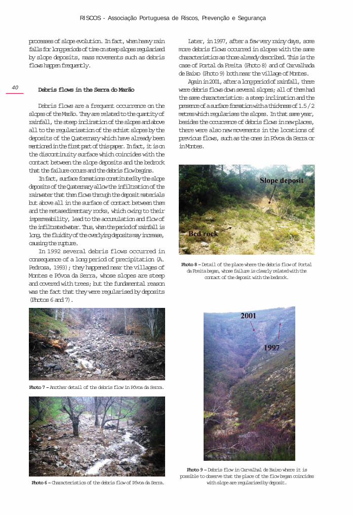
Later, in 1997, after a few very rainy days, somemore debris flows occurred in slopes with the samecharacteristics as those already described. This is thecase of Portal da Freita (Photo 8) and of Carvalhadade Baixo (Photo 9) both near the village of Montes.
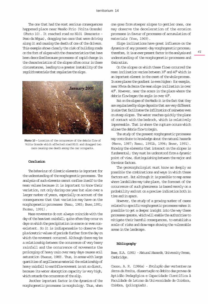
Again in 2001, after a long period of rainfall, therewere debris flows down several slopes; all of them hadthe same characteristics: a steep inclination and thepresence of a surface formation with a thickness of 1.5 / 2metres which regularises the slopes. In that same year,besides the occurrence of debris flows in new places,there were also new movements in the locations ofprevious flows, such as the ones in Póvoa da Serra orin Montes.
Photo 6 – Characteristics of the debris flow of Póvoa da Serra.
Photo 7 – Another detail of the debris flow in Póvoa da Serra.
Photo 9 – Debris flow in Carvalhal de Baixo where it ispossible to observe that the place of the flow began coincides
with slope are regularised by deposit.
Photo 8 – Detail of the place where the debris flow of Portalda Freita began, whose failure is clearly related with the
contact of the deposit with the bedrock.
territorium 14
41
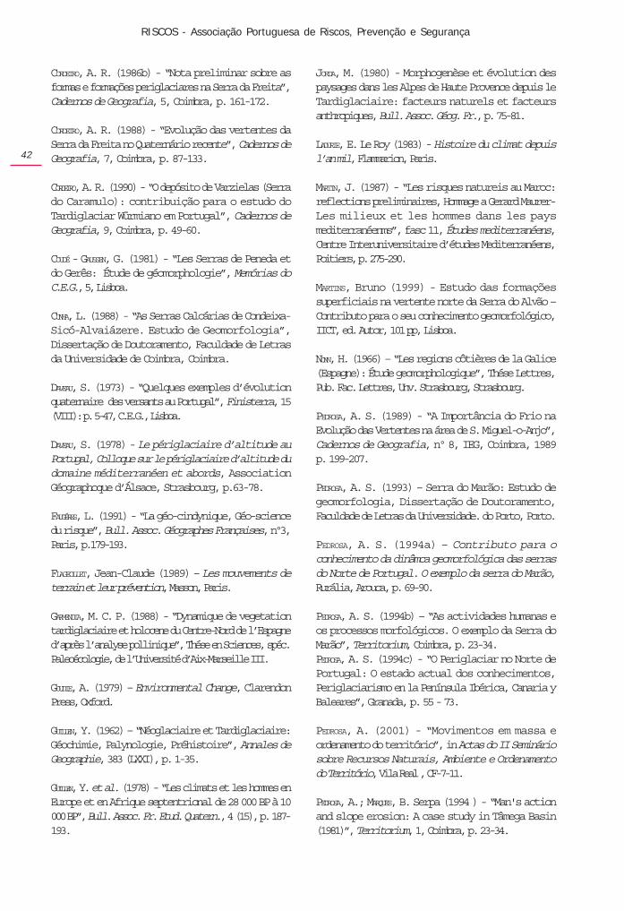
The one that had the most serious consequenceshappened place near Mesão Frio (Volta Grande)(Photo 10). It reached road no N101 (Amarante –Peso da Régua), dragging two cars that were drivingalong it and causing the death of one of the drivers.This example shows clearly the risk of building roadson the foot of slopes with the characteristics that havebeen described because processes of rapid change inthe characteristics of the slopes often occur in thesecircumstances, leading to a greater instability of theregolith materials that regularise the slope.
one goes from steeper slopes to gentler ones, onemay observe the deceleration of the erosionprocesses in favour of processes of accumulation ofmaterials (YOUNG, 1969).
Slope inclinations have great influence on thedynamics of any present-day morphogenetic process;therefore, it is an ever present factor in the analysis andunderstanding of the morphogenetic processes andtheir action.
On the slopes on which these flows occurred themean inclination varies between 30º and 40º which isan important element in the onset of the whole process.In some places the gradient is even higher: for example,near Póvoa da Serra the mean slope inclination is over40º. However, near the scars in the place where thedebris flow began the angle is over 60º.
But on the slopes of the Marão it is the fact that theyare regularised by slope deposits that are very differentin size that facilitates the infiltration of rainwater evenon steep slopes. The water reaches quickly the planeof contact with the bedrock, which is relativelyimpermeable. That is where the rupture occurs whichallows the debris flow to begin.
The study of the present morphogenetic processesmay contribute to knowledge about the natural hazards(MARTIN, 1987; REBELO, 1991b, 1994; BRYANT, 1991).Knowing the elements that interact on the slopes isfundamental; they must be understood from a dynamicpoint of view, distinguishing between the major andthe minor factors.
The geomorphologist must know as deeply aspossible the combinations and ways in which thesefactors act. But although it is possible to map areaswhere landslides may take place, the forecast of theoccurrence of such phenomena is based merely on aprobability and not on a precise indication both intime and in space.
However, the study of a growing number of casesrelated to specific morphogenetic processes makes itpossible to get a deeper insight into the way theseprocesses operate, which will enable the authorities tomitigate their harmful consequences, to establish ascale of risks and draw maps showing the vulnerableareas in the landscape.
Bibliography
BRYANT, E.A. (1991) - Natural Hazards, University Press,Cambridge.
CORDEIRO, A. R. (1986a) - Evolução das vertentes naSerra da Freita, dissertação no âmbito das provas deAptidão Pedagógica e Capacidade Científica àFaculdade de Letras da Universidade de Coimbra,Coimbra, (policopiado).
Photo 10 – Location of the occurrence of the debris flow of Volta Grande which affected road N101 and dragged two
cars causing one death among the car occupants.
Conclusion
The behaviour of climatic elements is important forthe understanding of the morphogenetic processes. Theanalysis of such elements cannot confine itself to themean values because it is important to know theirvariation, not only during one year but also over alarger number of years, especially on account of theconsequences that that variation may have on themorphogenetic processes (REBELO, 1983; BRYANT,1991;FAUGÈRES, 1991).
Mass movements do not always coincide with theday of the heaviest rainfall; quite often they occur ondays on which the precipitation is scarce or even non-existent. So it is indispensable to observe thepluviometric values of periods further from the day onwhich the movement occurred. Although there may bea relationship between the occurrence of very heavyrainfall and the occurrence of movements theprolonging of heavy rain over many days causes soilsaturation (FLAGEOLLET, 1989). Thus, in areas with largequantities of argillaceous material the relationship ofheavy rainfall to earthflow movement is not so direct,because its water absorption capacity is very high,which retards the occurrence of the slip.
Another important factor in the dynamics of themorphogenetic processes is morphology. Thus, when
RISCOS - Associação Portuguesa de Riscos, Prevenção e Segurança
42
CORDEIRO, A. R. (1986b) - “Nota preliminar sobre asformas e formações periglaciares na Serra da Freita”,Cadernos de Geografia, 5, Coimbra, p. 161-172.
CORDEIRO, A. R. (1988) - “Evolução das vertentes daSerra da Freita no Quaternário recente”, Cadernos deGeografia, 7, Coimbra, p. 87-133.
CORDEIRO, A. R. (1990) - “O depósito de Varzielas (Serrado Caramulo): contribuição para o estudo doTardiglaciar Würmiano em Portugal”, Cadernos deGeografia, 9, Coimbra, p. 49-60.
COUDÉ - GAUSSEN, G. (1981) - “Les Serras de Peneda etdo Gerês: Étude de géomorphologie”, Memórias doC.E.G., 5, Lisboa.
CUNHA, L. (1988) - “As Serras Calcárias de Condeixa-Sicó-Alvaiázere. Estudo de Geomorfologia”,Dissertação de Doutoramento, Faculdade de Letrasda Universidade de Coimbra, Coimbra.
DAVEAU, S. (1973) - “Quelques exemples d’évolutionquaternaire des versants au Portugal”, Finisterra, 15(VIII): p. 5-47, C.E.G., Lisboa.
DAVEAU, S. (1978) - Le périglaciaire d’altitude auPortugal, Colloque sur le périglaciaire d’altitude dudomaine méditerranéen et abords, AssociationGéographoque d’Álsace, Strasbourg, p.63-78.
FAUGÉRES, L. (1991) - “La géo-cindynique, Géo-sciencedu risque”, Bull. Assoc. Géographes Françaises, nº3,Paris, p.179-193.
FLAGEOLLET, Jean-Claude (1989) – Les mouvements deterrain et leur prévention, Masson, Paris.
GARMENDIA, M. C. P. (1988) - “Dynamique de vegetationtardiglaciaire et holocene du Centre-Nord de l’Espagned’après l’analyse pollinique”, Thése en Sciences, spéc.Paleoécologie, de l’Université d’Aix-Marseille III.
GOUDIE, A. (1979) – Environmental Change, ClarendonPress, Oxford.
GUILLEN, Y. (1962) – “Néoglaciaire et Tardiglaciaire:Géochimie, Palynologie, Préhistoire”, Annales deGeographie, 383 (LXXI), p. 1-35.
GUILLEN, Y. et al. (1978) - “Les climats et les hommes enEurope et en Afrique septentrional de 28 000 BP à 10000 BP”, Bull. Assoc. Fr. Etud. Quatern., 4 (15), p. 187-193.
JORDA, M. (1980) - Morphogenèse et évolution despaysages dans les Alpes de Haute Provence depuis leTardiglaciaire: facteurs naturels et facteursanthropiques, Bull. Assoc. Géog. Fr., p. 75-81.
LADURIE, E. Le Roy (1983) - Histoire du climat depuisl’an mil, Flammarion, Paris.
MARTIN, J. (1987) - “Les risques natureis au Maroc:reflections preliminaires, Hommage a Gerard Maurer-Les milieux et les hommes dans les paysmediterranéenms”, fasc 11, Études mediterranéens,Centre Interuniversitaire d’études Mediterranéens,Poitiers, p. 275-290.
MARTINS, Bruno (1999) - Estudo das formaçõessuperficiais na vertente norte da Serra do Alvão –Contributo para o seu conhecimento geomorfológico,IICT, ed. Autor, 101 pp, Lisboa.
NONN, H. (1966) – “Les regions côtières de la Galice(Espagne): Étude geomorphologique”, Thése Lettres,Pub. Fac. Lettres, Unv. Strasbourg, Strasbourg.
PEDROSA, A. S. (1989) - “A Importância do Frio naEvolução das Vertentes na área de S. Miguel-o-Anjo”,Cadernos de Geografia, nº 8, IEG, Coimbra, 1989p. 199-207.
PEDROSA, A. S. (1993) – Serra do Marão: Estudo degeomorfologia, Dissertação de Doutoramento,Faculdade de Letras da Universidade. do Porto, Porto.
PEDROSA, A. S. (1994a) – Contributo para oconhecimento da dinâmca geomorfológica das serrasdo Norte de Portugal. O exemplo da serra do Marão,Rurália, Arouca, p. 69-90.
PEDROSA, A. S. (1994b) – “As actividades humanas eos processos morfológicos. O exemplo da Serra doMarão”, Territorium, Coimbra, p. 23-34.PEDROSA, A. S. (1994c) - “O Periglaciar no Norte dePortugal: O estado actual dos conhecimentos,Periglaciarismo en la Península Ibérica, Canaria yBaleares”, Granada, p. 55 - 73.
PEDROSA, A. (2001) - “Movimentos em massa eordenamento do território”, in Actas do II Semináriosobre Recursos Naturais, Ambiente e Ordenamentodo Território, Vila Real , CF-7-11.
PEDROSA, A.; MARQUES, B. Serpa (1994 ) - “Man's actionand slope erosion: A case study in Tâmega Basin(1981)”, Territorium, 1, Coimbra, p. 23-34.
territorium 14
43
PEDROSA, A. S. et. al. (1995) – “Covelo do Gerês:Contribuição para o estudo dos movimentos de massano Norte de Portugal”, Territorium, 2, Coimbra, p.21-32.
PEDROSA, A. S. et. al. (2001) – Metodologia para oestudo dos ravinamentos, Metodologias de Estudo deProcessos de Erosão, FLUP, Porto, p. 85-98.
PEDROSA, A. S.; LOURENÇO, L.; FELGUEIRAS, J. (2001) -“Movimentos em massa: exemplos ocorridos no Nortede Portugal”, Revista Técnica e Formativa da EscolaNacional de Bombeiros, Ano 5, nº 17, p. 25-39.
PEDROSA, A; MARTINS, Bruno (2001) - “Os movimentosem massa e os depósitos de vertente em áreasmetassedimentares: alguns exemplos no Norte dePortugal”, in Actas do II Seminário sobre RecursosNaturais, Ambiente e Ordenamento do Território, VilaReal, CO-161-169.
REBELO, F. (1975) - “Serras de Valongo: estudo deGeomorfologia”, Suplementos de Biblos, 9, Coimbra.
REBELO, Fernando (1985) - "História e Geografia Física- Reflexões em torno de um caso de interdisciplinaridadedesenvolvido por Jaime Cortesão". Cidadania eHistória, Revista de História Económica e Social, 6-7,Lisboa, Sá da Costa, p. 103-110.
REBELO, F. (1986) - “Modelado periglaciar de baixaaltitude em Portugal”, Cadernos de Geografia, 5,Coimbra, p. 127-137.
REBELO, F. (1991) – “Geografia Física e Riscos naturais:alguns exemplos de riscos geomorfologicos emvertentes e arribas no domínio mediterrânico”, Biblos,LXVII, Coimbra, p. 353-371.
REBELO, F. (1994) – “Do ordenamento do território àgestão dos riscos naturais. A importância da GeografiaFísica salientada através de casos seleccionados emPortugal”, Territorium, Coimbra, p. 7-15.
REBELO, F. (2001) – Riscos naturais e acção antrópica,Imprensa da Universidade, Coimbra.
REBELO, F; PEDROSA, A. (1993) - “Novas observaçõessobre depósitos relacionados com o frio na área deValongo - S. Miguel-o-Anjo”, El Cuaternario en Espanay Portugal, volume II, Madrid, p. 501-504.
VLIET-LANOE, B. (1988) - Le role de la glace de ségrégationdans les formations superficielles de l’Europe de l’Ouest.Processus et héritages. Thèses de Doctorat d’Etat Mens.Géographie, Univ. Paris I, tome 1 et 2, Caen, 854 pp.
VALADAS, Bernard (1984) - Les hautes terres du massifCentral Fançais. Contribution à l’étude desmorphodynamiques récentes sur versants cristallins etvolcaniques, Vol. I, II, Université de Paris I, Paris.