COASTAL SATELLITE ALTIMETRY DATA AND THE...
4
II Simpósio Brasileiro de Geomática Presidente Prudente - SP, 24-27 de julho de 2007 V Colóquio Brasileiro de Ciências Geodésicas ISSN 1981-6251, p. 1071-1074 R. T. Luz; W. Bosch; S. R. C. Freitas; R. Dalazoana; B. Heck COASTAL SATELLITE ALTIMETRY DATA AND THE EVALUATION OF BRAZILIAN VERTICAL REFERENCE SYSTEM AND FRAME ROBERTO TEIXEIRA LUZ (1,2) WOLFGANG BOSCH (3) SÍLVIO ROGÉRIO CORREIA DE FREITAS (1) , REGIANE DALAZOANA (1) BERNHARD HECK (4) (1) Paraná Federal University, Geodetic Sciences Program (UFPR/CPGCG), Curitiba, PR, Brazil { robtluz , sfreitas , regiane } @ ufpr.br (2) Brazilian Geography and Statistics Institute, Geodesy Coordination (IBGE/CGED), Rio de Janeiro, RJ, Brazil roberto.luz @ ibge.gov.br (3) German Geodetic Research Institute (Deutsches Geodätisches Forschungsinstitut, DGFI), München, Germany bosch @ dgfi.badw.de (4) Karlsruhe University, Geodetic Institute (Universität Karlsruhe, Geodätisches Institut, GIK), Karlsruhe, Germany heck @ gik.uni-karlsruhe.de RESUMO - A Altimetria por Satélites (Sat-Alt) é um importante meio para a conexão entre referenciais geodésicos verticais e destes com os futuros sistemas globais de altitudes. O próprio conceito de geóide global colhe subsídios essenciais da Sat-Alt para sua adequada realização. No entanto, os resultados da Sat-Alt em áreas costeiras e de águas rasas ainda carecem de aprimoramento. Esforços anteriores para tal aprimoramento na costa brasileira foram desenvolvidos na região do Datum de Imbituba, a fim de permitir a integração dos dados de Sat-Alt às séries temporais de observações maregráficas. O presente trabalho mostra a continuação daqueles estudos, abordando aspectos da conexão dos níveis de referência das observações maregráficas e de Sat-Alt em algumas estações da Rede Maregráfica Permanente para Geodésia (RMPG). Espera-se, com isso, possibilitar uma avaliação independente dos estudos que visam o refinamento da componente vertical do Sistema Geodésico Brasileiro, em desenvolvimento pelo mesmo grupo de pesquisa e também apresentados neste evento. EXTENDED ABSTRACT The benchmarks (BMs) of the Brazilian Fundamental Vertical Network (BFVN) have heights which are referred to the Brazilian Vertical Datum at Imbituba (BVD-I), defined by the mean sea level (MSL) established with tide gauge data collected from 1949 to 1957 at Imbituba Harbour, southern Brazil (Alencar, 1990). Several tide gauges were tied to BFVN since the beginning of its establishment in 1945, but the comparison of each local MSL to BVD-I is very problematic, mainly because of two distinguished sources of errors. On one hand, BFVN's heights are computed without gravity measurements – only normal-orthometric corrections are applied (Ribeiro, 1989). On the other hand, the sea surface topography (SSTop) has very distinctive behaviour at each location along the coast, depending on local water temperature, prevailing winds, geostrophic effects, types of equipments etc (Luz, 1996). Figure 1 shows the differences between heights referred to BVD-I and local MSL along Brazilian coast – presently there are no reliable information on the contributions from BFVN's internal errors and from local SSTop at each tide gauge to these differences. It must be also emphasized that both quantities are time-dependent, so the MSL and SSTop values used for this kind of comparison must refer to the same period. Procedures for the improvement of Brazilian heights are the main subject of a research under development by the same group (Freitas et al., 2002; Ferreira et al., 2007, this Colloquium). The first activities regarding the integration of BFVN conventional data (levelling and gravity surveys, i.e., the "land part" of that research) toward its link to a future world height system must be the computation of high precision physical heights in more than 65000 benchmarks (Luz et al., 2006; Drewes et al., 2002). In the past, the evaluation of BFVN's internal errors was very difficult due to the absence of an independent, suitable tool for this purpose (Luz and Guimaräes, 2001; id., 2003).
-
Upload
vuongkhanh -
Category
Documents
-
view
214 -
download
0
Transcript of COASTAL SATELLITE ALTIMETRY DATA AND THE...
II Simpósio Brasileiro de Geomática Presidente Prudente - SP, 24-27 de julho de 2007
V Colóquio Brasileiro de Ciências Geodésicas ISSN 1981-6251, p. 1071-1074
R. T. Luz; W. Bosch; S. R. C. Freitas; R. Dalazoana; B. Heck
COASTAL SATELLITE ALTIMETRY DATA AND THE EVALUATION OF BRAZILIAN VERTICAL REFERENCE SYSTEM AND FRAME
ROBERTO TEIXEIRA LUZ
(1,2)
WOLFGANG BOSCH (3)
SÍLVIO ROGÉRIO CORREIA DE FREITAS (1)
, REGIANE DALAZOANA (1)
BERNHARD HECK (4)
(1) Paraná Federal University, Geodetic Sciences Program (UFPR/CPGCG), Curitiba, PR, Brazil
{ robtluz , sfreitas , regiane } @ ufpr.br
(2) Brazilian Geography and Statistics Institute, Geodesy Coordination (IBGE/CGED), Rio de Janeiro, RJ, Brazil roberto.luz @ ibge.gov.br
(3) German Geodetic Research Institute (Deutsches Geodätisches Forschungsinstitut, DGFI), München, Germany
bosch @ dgfi.badw.de
(4) Karlsruhe University, Geodetic Institute (Universität Karlsruhe, Geodätisches Institut, GIK), Karlsruhe, Germany heck @ gik.uni-karlsruhe.de
RESUMO - A Altimetria por Satélites (Sat-Alt) é um importante meio para a conexão entre referenciais geodésicos verticais e destes com os futuros sistemas globais de altitudes. O próprio conceito de geóide global colhe subsídios essenciais da Sat-Alt para sua adequada realização. No entanto, os resultados da Sat-Alt em áreas costeiras e de águas rasas ainda carecem de aprimoramento. Esforços anteriores para tal aprimoramento na costa brasileira foram desenvolvidos na região do Datum de Imbituba, a fim de permitir a integração dos dados de Sat-Alt às séries temporais de observações maregráficas. O presente trabalho mostra a continuação daqueles estudos, abordando aspectos da conexão dos níveis de referência das observações maregráficas e de Sat-Alt em algumas estações da Rede Maregráfica Permanente para Geodésia (RMPG). Espera-se, com isso, possibilitar uma avaliação independente dos estudos que visam o refinamento da componente vertical do Sistema Geodésico Brasileiro, em desenvolvimento pelo mesmo grupo de pesquisa e também apresentados neste evento.
EXTENDED ABSTRACT
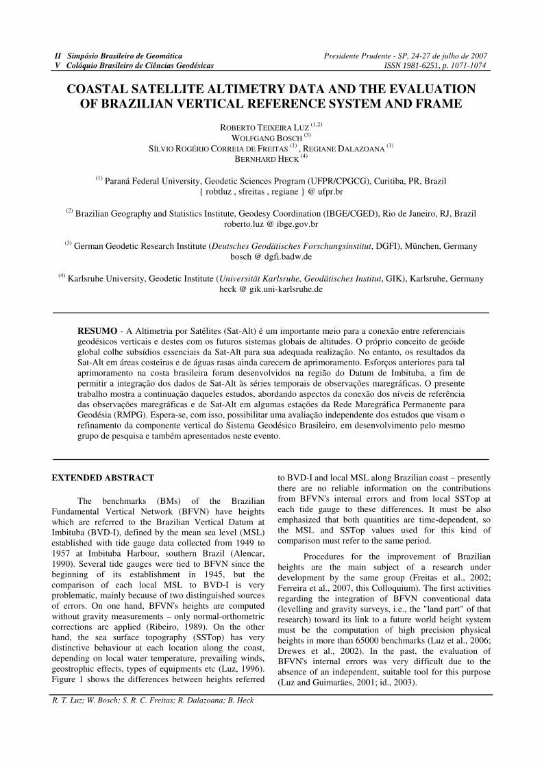
The benchmarks (BMs) of the Brazilian Fundamental Vertical Network (BFVN) have heights which are referred to the Brazilian Vertical Datum at Imbituba (BVD-I), defined by the mean sea level (MSL) established with tide gauge data collected from 1949 to 1957 at Imbituba Harbour, southern Brazil (Alencar, 1990). Several tide gauges were tied to BFVN since the beginning of its establishment in 1945, but the comparison of each local MSL to BVD-I is very problematic, mainly because of two distinguished sources of errors. On one hand, BFVN's heights are computed without gravity measurements – only normal-orthometric corrections are applied (Ribeiro, 1989). On the other hand, the sea surface topography (SSTop) has very distinctive behaviour at each location along the coast, depending on local water temperature, prevailing winds, geostrophic effects, types of equipments etc (Luz, 1996). Figure 1 shows the differences between heights referred
to BVD-I and local MSL along Brazilian coast – presently there are no reliable information on the contributions from BFVN's internal errors and from local SSTop at each tide gauge to these differences. It must be also emphasized that both quantities are time-dependent, so the MSL and SSTop values used for this kind of comparison must refer to the same period.
Procedures for the improvement of Brazilian heights are the main subject of a research under development by the same group (Freitas et al., 2002; Ferreira et al., 2007, this Colloquium). The first activities regarding the integration of BFVN conventional data (levelling and gravity surveys, i.e., the "land part" of that research) toward its link to a future world height system must be the computation of high precision physical heights in more than 65000 benchmarks (Luz et al., 2006; Drewes et al., 2002). In the past, the evaluation of BFVN's internal errors was very difficult due to the absence of an independent, suitable tool for this purpose (Luz and Guimaräes, 2001; id., 2003).
II Simpósio Brasileiro de Geomática Presidente Prudente - SP, 24-27 de julho de 2007
V Colóquio Brasileiro de Ciências Geodésicas
R. T. Luz; W. Bosch; S. R. C. Freitas; R. Dalazoana; B. Heck
Figure 1 – Discrepancies between several local MSL along Brazilian coast and the corresponding heights referred to BVD-I, from three different adjustments (Source: Luz et al., 2007a, this Colloquium)
The integration with satellite altimetry data for the homogenization of the tide gauge reference levels is one of the ways for such an independent validation of those procedures. Satellite altimetry gives highly precise information on SSTop over a great part of the oceans, thus contributing for a reliable realization of the concept of "Global Geoid" (Heck and Rummel, 1990; Heck, 2004). However, SSTop is characterized by strong differences of data quality at deep, open sea and at coastal or shallow waters (Bosch, 2002; Bosch et al., 2007).
Besides the natural phenomenon by itself, the processing strategies also show degraded performance at coastal areas – e.g. the standard waveform used for selecting or discarding the returning radar pulses, or the global tide models used for reduction of altimeter observations. Thus, SSTop derived from satellite altimetry missions, at open, deep sea, must be suitably “propagated”, or extrapolated, along the satellite tracks towards the coastal tide gauges. First attempts to such kind of improvement at the Brazilian coast were performed at the own BVD-I (Dalazoana, 2006). These studies allowed the comparison of spectral characteristics of altimetric open sea data and coastal tide gauge observations, as well as their use for the extrapolation of Sat-Alt data.
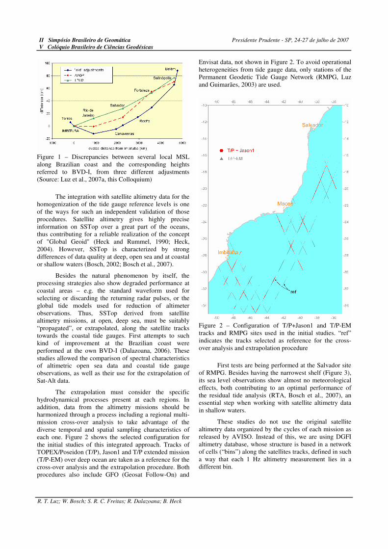
The extrapolation must consider the specific hydrodynamical processes present at each regions. In addition, data from the altimetry missions should be harmonized through a process including a regional multi-mission cross-over analysis to take advantage of the diverse temporal and spatial sampling characteristics of each one. Figure 2 shows the selected configuration for the initial studies of this integrated approach. Tracks of TOPEX/Poseidon (T/P), Jason1 and T/P extended mission (T/P-EM) over deep ocean are taken as a reference for the cross-over analysis and the extrapolation procedure. Both procedures also include GFO (Geosat Follow-On) and
Envisat data, not shown in Figure 2. To avoid operational heterogeneities from tide gauge data, only stations of the Permanent Geodetic Tide Gauge Network (RMPG, Luz and Guimarães, 2003) are used.
Figure 2 – Configuration of T/P+Jason1 and T/P-EM tracks and RMPG sites used in the initial studies. “ref” indicates the tracks selected as reference for the cross-over analysis and extrapolation procedure
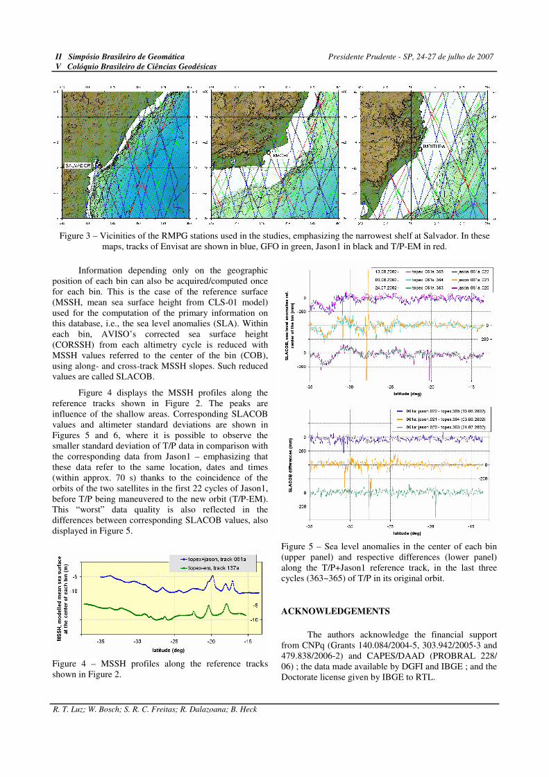
First tests are being performed at the Salvador site of RMPG. Besides having the narrowest shelf (Figure 3), its sea level observations show almost no meteorological effects, both contributing to an optimal performance of the residual tide analysis (RTA, Bosch et al., 2007), an essential step when working with satellite altimetry data in shallow waters.
These studies do not use the original satellite altimetry data organized by the cycles of each mission as released by AVISO. Instead of this, we are using DGFI altimetry database, whose structure is based in a network of cells (“bins”) along the satellites tracks, defined in such a way that each 1 Hz altimetry measurement lies in a different bin.
II Simpósio Brasileiro de Geomática Presidente Prudente - SP, 24-27 de julho de 2007
V Colóquio Brasileiro de Ciências Geodésicas
R. T. Luz; W. Bosch; S. R. C. Freitas; R. Dalazoana; B. Heck
Figure 3 – Vicinities of the RMPG stations used in the studies, emphasizing the narrowest shelf at Salvador. In these maps, tracks of Envisat are shown in blue, GFO in green, Jason1 in black and T/P-EM in red.
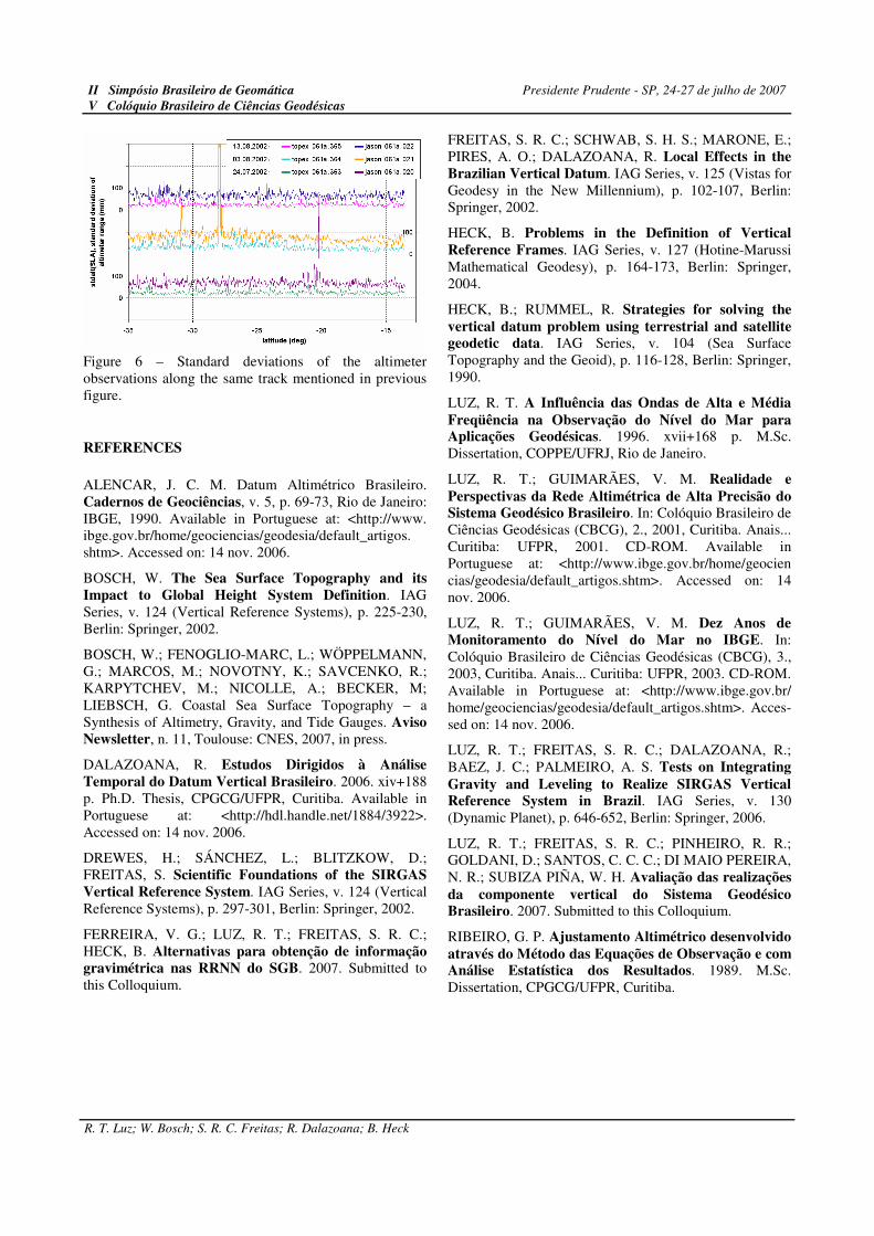
Information depending only on the geographic position of each bin can also be acquired/computed once for each bin. This is the case of the reference surface (MSSH, mean sea surface height from CLS-01 model) used for the computation of the primary information on this database, i.e., the sea level anomalies (SLA). Within each bin, AVISO’s corrected sea surface height (CORSSH) from each altimetry cycle is reduced with MSSH values referred to the center of the bin (COB), using along- and cross-track MSSH slopes. Such reduced values are called SLACOB.
Figure 4 displays the MSSH profiles along the reference tracks shown in Figure 2. The peaks are influence of the shallow areas. Corresponding SLACOB values and altimeter standard deviations are shown in Figures 5 and 6, where it is possible to observe the smaller standard deviation of T/P data in comparison with the corresponding data from Jason1 – emphasizing that these data refer to the same location, dates and times (within approx. 70 s) thanks to the coincidence of the orbits of the two satellites in the first 22 cycles of Jason1, before T/P being maneuvered to the new orbit (T/P-EM). This “worst” data quality is also reflected in the differences between corresponding SLACOB values, also displayed in Figure 5.
Figure 4 – MSSH profiles along the reference tracks shown in Figure 2.
Figure 5 – Sea level anomalies in the center of each bin (upper panel) and respective differences (lower panel) along the T/P+Jason1 reference track, in the last three cycles (363~365) of T/P in its original orbit.
ACKNOWLEDGEMENTS
The authors acknowledge the financial support from CNPq (Grants 140.084/2004-5, 303.942/2005-3 and 479.838/2006-2) and CAPES/DAAD (PROBRAL 228/ 06) ; the data made available by DGFI and IBGE ; and the Doctorate license given by IBGE to RTL.
II Simpósio Brasileiro de Geomática Presidente Prudente - SP, 24-27 de julho de 2007
V Colóquio Brasileiro de Ciências Geodésicas
R. T. Luz; W. Bosch; S. R. C. Freitas; R. Dalazoana; B. Heck
Figure 6 – Standard deviations of the altimeter observations along the same track mentioned in previous figure.
REFERENCES
ALENCAR, J. C. M. Datum Altimétrico Brasileiro. Cadernos de Geociências, v. 5, p. 69-73, Rio de Janeiro: IBGE, 1990. Available in Portuguese at: <http://www. ibge.gov.br/home/geociencias/geodesia/default_artigos. shtm>. Accessed on: 14 nov. 2006.
BOSCH, W. The Sea Surface Topography and its Impact to Global Height System Definition. IAG Series, v. 124 (Vertical Reference Systems), p. 225-230, Berlin: Springer, 2002.
BOSCH, W.; FENOGLIO-MARC, L.; WÖPPELMANN, G.; MARCOS, M.; NOVOTNY, K.; SAVCENKO, R.; KARPYTCHEV, M.; NICOLLE, A.; BECKER, M; LIEBSCH, G. Coastal Sea Surface Topography – a Synthesis of Altimetry, Gravity, and Tide Gauges. Aviso Newsletter, n. 11, Toulouse: CNES, 2007, in press.
DALAZOANA, R. Estudos Dirigidos à Análise Temporal do Datum Vertical Brasileiro. 2006. xiv+188 p. Ph.D. Thesis, CPGCG/UFPR, Curitiba. Available in Portuguese at: <http://hdl.handle.net/1884/3922>. Accessed on: 14 nov. 2006.
DREWES, H.; SÁNCHEZ, L.; BLITZKOW, D.; FREITAS, S. Scientific Foundations of the SIRGAS Vertical Reference System. IAG Series, v. 124 (Vertical Reference Systems), p. 297-301, Berlin: Springer, 2002.
FERREIRA, V. G.; LUZ, R. T.; FREITAS, S. R. C.; HECK, B. Alternativas para obtenção de informação gravimétrica nas RRNN do SGB. 2007. Submitted to this Colloquium.
FREITAS, S. R. C.; SCHWAB, S. H. S.; MARONE, E.; PIRES, A. O.; DALAZOANA, R. Local Effects in the Brazilian Vertical Datum. IAG Series, v. 125 (Vistas for Geodesy in the New Millennium), p. 102-107, Berlin: Springer, 2002.
HECK, B. Problems in the Definition of Vertical Reference Frames. IAG Series, v. 127 (Hotine-Marussi Mathematical Geodesy), p. 164-173, Berlin: Springer, 2004.
HECK, B.; RUMMEL, R. Strategies for solving the
vertical datum problem using terrestrial and satellite geodetic data. IAG Series, v. 104 (Sea Surface Topography and the Geoid), p. 116-128, Berlin: Springer, 1990.
LUZ, R. T. A Influência das Ondas de Alta e Média
Freqüência na Observação do Nível do Mar para Aplicações Geodésicas. 1996. xvii+168 p. M.Sc. Dissertation, COPPE/UFRJ, Rio de Janeiro.
LUZ, R. T.; GUIMARÃES, V. M. Realidade e
Perspectivas da Rede Altimétrica de Alta Precisão do Sistema Geodésico Brasileiro. In: Colóquio Brasileiro de Ciências Geodésicas (CBCG), 2., 2001, Curitiba. Anais... Curitiba: UFPR, 2001. CD-ROM. Available in Portuguese at: <http://www.ibge.gov.br/home/geocien cias/geodesia/default_artigos.shtm>. Accessed on: 14 nov. 2006.
LUZ, R. T.; GUIMARÃES, V. M. Dez Anos de Monitoramento do Nível do Mar no IBGE. In: Colóquio Brasileiro de Ciências Geodésicas (CBCG), 3., 2003, Curitiba. Anais... Curitiba: UFPR, 2003. CD-ROM. Available in Portuguese at: <http://www.ibge.gov.br/ home/geociencias/geodesia/default_artigos.shtm>. Acces-sed on: 14 nov. 2006.
LUZ, R. T.; FREITAS, S. R. C.; DALAZOANA, R.; BAEZ, J. C.; PALMEIRO, A. S. Tests on Integrating
Gravity and Leveling to Realize SIRGAS Vertical Reference System in Brazil. IAG Series, v. 130 (Dynamic Planet), p. 646-652, Berlin: Springer, 2006.
LUZ, R. T.; FREITAS, S. R. C.; PINHEIRO, R. R.; GOLDANI, D.; SANTOS, C. C. C.; DI MAIO PEREIRA, N. R.; SUBIZA PIÑA, W. H. Avaliação das realizações
da componente vertical do Sistema Geodésico Brasileiro. 2007. Submitted to this Colloquium.
RIBEIRO, G. P. Ajustamento Altimétrico desenvolvido
através do Método das Equações de Observação e com Análise Estatística dos Resultados. 1989. M.Sc. Dissertation, CPGCG/UFPR, Curitiba.